
Dryandra Woodland facts for kids
Quick facts for kids Dryandra Woodland |
|
|---|---|
| Noongar: Wilgadjny | |

Entrance to Dryandra Woodland on the Narrogin-Wandering road
|
|
| Location | Wheatbelt (Western Australia), Western Australia, Australia |
| Area | 280.66 km2 (108.36 sq mi) |
| Established | 1976 |
| Named for | Banksia ser. Dryandra |
| Website | WA Parks and Wildlife Service |
| Official name | Dryandra Woodland |
| Type | Natural |
| Designated | 21 March 1978 |
| Reference no. | 9928 |
| Place File Number | 5/06/094/0001 |
The Dryandra Woodland is a special nature area in Western Australia. It's about 164 kilometres (102 miles) south-east of Perth. This woodland is made up of 17 separate sections. They are managed by the Western Australian Department of Parks and Wildlife.
Dryandra is one of the state's most important conservation areas. Even though it was once used for logging, many threatened animals are now recovering here. This is thanks to efforts to remove animals like foxes and feral cats. The total area of the woodland is about 28,066 hectares (108.36 square miles). It is also listed on the Register of the National Estate. This means it's recognized as an important natural place.
Besides being a home for wildlife, Dryandra is very important to the local Noongar people. They have strong cultural connections to this land.
Contents
What is Dryandra Woodland?

Dryandra Woodland is located on an ancient, gently rolling landscape. This land is mostly made of granite rock. The woodland sits between two different plant regions. It's a rare piece of the original open eucalypt forests. These forests once covered much of the wheatbelt region. Most of them were cleared for farming starting in the 1890s.
The plants here are a mix of those found in the wetter jarrah forests and the drier wheatbelt areas. Dryandra is famous for its large groups of wandoo (Eucalyptus wandoo), powderbark wandoo (E. accedens), and salmon white gum (E. lane-poolei). These trees provide a safe place for native plants and animals. This is especially important because much of the surrounding land is affected by saltiness.
Other trees like jarrah (E. marginata) and marri (Corymbia calophylla) also grow here. The lower plants include rock sheoak (Allocasuarina huegeliana) and many Banksia ser. Dryandra shrubs. The woodland is named after these Dryandra shrubs. An arboretum (a tree garden) on Tomingley Road has many different Australian native plants.

The 17 parts of Dryandra Woodland are surrounded by farmland. Some roads and other strips of natural plants connect these woodland "islands." Some nearby landowners have even replanted areas to create more connections. These connections are vital for animals. They allow them to move between different blocks to find food, shelter, breeding spots, and partners.
Amazing Animals of Dryandra
Threatened animals get extra protection at the 'Barna Mia' animal sanctuary. Visitors can even take night tours by booking ahead. Many native marsupials live here. These include the woylie (Bettongia penicillata), bilby (Macrotis lagotis), mala (Lagorchestes hirsutus), boodie (Bettongia lesueur), and marl (or western barred bandicoot: Perameles bougainville).
.jpg)
The woodland is home to at least 98 types of birds. One special bird is the almost flightless malleefowl (Leipoa ocellata). Several types of frogs also live here. This is because Dryandra is a meeting point for different environments.
Climate and Weather
Dryandra has a semi-dry climate, similar to a warm, dry Mediterranean climate. It has about seven to eight dry months each year. The average rainfall is around 500 millimetres (20 in) per year. The weather changes more here than in coastal areas. Most of the rain falls between May and September. In January, the average daily high temperature is 30.9 °C (87.6 °F). In August, the average daily low temperature is 5.6 °C (42.1 °F).
Protecting Animals and Plants

Many animals living in Dryandra Woodland are considered 'threatened'. This means they are at risk of disappearing. Here are some of them:
| Common name | Scientific name | Category |
|---|---|---|
| Brush-tailed bettong (also known as woylie) |
Bettongia penicillata | Critically endangered |
| Red-tailed phascogale | Phascogale calura | Near threatened |
| Short-billed black-cockatoo (also known as Carnaby's black cockatoo) |
Calyptorhynchus latirostris | Endangered |
| Numbat | Myrmecobius fasciatus | Vulnerable |
| Chuditch (also known as western quoll) |
Dasyurus geoffroii | Near threatened |
| Malleefowl | Leipoa ocellata | Vulnerable |
Dryandra Woodland is very important for three nationally endangered species: the woylie, the red-tailed phascogale, and the numbat. More than half of all known numbats live here! Thanks to efforts to control feral cats, the numbat population in Dryandra Woodland grew to 35 by November 2020. This is a big improvement from just 5 in 2018.
Over 800 native plant types have been found in Dryandra Woodland. Fifteen of these are special 'priority species'. This means they are rare but have some populations in safe areas.
| Scientific name | Conservation priority code |
|---|---|
| Grevillea crowleyae | P2 |
| Amanita carneiphylla | P2 |
| Andersonia bifida | P2 |
| Marianthus dryandra | P2 |
| Chamelaucium croxfordiae ms | P2 |
| Banksia acanthopoda | P2 |
| Persoonia hakeiformis | P2 |
| Schoenus aff. clandestinus | P2 |
| Triglochin stowardii | P3 |
| Acacia brachyphylla var. recurvata | P3 |
| Acacia deflexa | P3 |
| Acacia semitrullata | P3 |
| Thysanotus tenuis | P3 |
| Banksia cynaroides | P4 |
| Gastrolobium tomentosum (woolly poison) | P4 |
The Mallet Industry

In the early 1900s, a big industry started in Dryandra. Workers harvested bark from brown mallet trees (Eucalyptus astringens). This bark was used to make leather. It had a high amount of a substance called tannin.
By the 1920s, most natural mallet trees were gone. So, from 1925 to 1962, new mallet tree farms were planted. This work provided jobs for many people during the Great Depression. About 4,000 hectares (9,900 acres) of mallet trees were planted. Seven steam trains and a sawmill helped the industry. Two dams, 'Lol Gray' and 'Old Mill Dam', provided water for the trains and nearby towns.
The mallet bark was ground up and sent to other countries. However, by the early 1960s, the industry ended. This was because there was too much tannin in the world, and new man-made tannins were available.
Today, about 30% of Dryandra is covered by these replanted forests. Trees are still harvested from these areas for timber. This is done carefully to make sure it doesn't harm the animals or plants. Local farmers also make tool handles from fallen wandoo and mallet wood. This small business makes over 100,000 tool handles each year.
Noongar People and Dryandra
Indigenous people have lived in this part of Australia for at least 40,000 years. The Noongar people are the traditional owners of the Dryandra area. They call it Wilgadjny.
So far, five important historical sites have been found in Dryandra. These include a special ochre pit. Ochre is a natural pigment used for body decoration and rock art. One Noongar person born in 1910 said the ochre pit was "a very spirity place" and to be avoided at night. Other sites include stone tools and a scarred tree. More surveys are planned to find other important Aboriginal sites.
The Department of Environment and Conservation is looking into allowing some cultural activities in the woodland. This could include hunting and camping. This would help older Noongar people teach traditional skills to younger generations. Any activities would be managed carefully to protect the woodland's nature.
How Dryandra Became a Protected Area

Most of the land in Dryandra Woodland was made a state forest in 1903. This was to protect water sources and grow wandoo and mallet trees.
In 1976, it was decided that Dryandra should be managed mainly as a nature reserve. This means protecting its plants and animals is the main goal. However, some limited timber harvesting from the planted areas is still allowed.
In 1995, a new plan was made for Dryandra. It suggested calling the whole area 'Dryandra Woodland'. This name shows that it's different from the taller, denser forests found elsewhere. The main goals of this plan were:
- To protect nature, allow recreation, and produce some timber.
- To "maintain and restore the natural environment." This includes helping people learn about the native plants and animals. It also means preserving any important historical or scientific features.
Visiting Dryandra Woodland

About 30,000 people visit Dryandra Woodland each year. Around 5,000 visitors stay overnight. You can camp at the Congelin and Gnaala Mia campgrounds. There's also the Lions Dryandra Village. This village uses old cottages from the 1920s forestry settlement. Next to the cottages is the Currawong Complex. It has several Nissen huts that can host up to 60 people in groups. The Lions Village was started in 1972 by Lions service clubs. They wanted to provide a holiday camp for children who needed it.
You can take two self-drive tours in Dryandra. They are 20 km (12 mi) and 25 km (16 mi) long. You follow a marked trail in your own car. At certain stops, you can tune your car radio to FM 100 MHz. You'll hear a recorded story about the area. Some stories are conversations between old forestry workers. Others explain interesting facts about the plants or animals nearby. For example, one stop talks about the natural poison pea plant (genus: Gastrolobium spp). This plant contains a poison called 1080. Native animals are not harmed by it, but it's deadly to introduced animals like foxes. This poison is used in programs like the Western Shield project to help control foxes.
You can also go on bushwalks along marked trails. These walks range from 1 to 12.5 kilometres (0.62 to 7.77 mi) long.
Images for kids
-
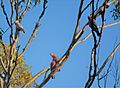
Galahs, Dryandra Woodland

