
Dryden, New York facts for kids
Quick facts for kids
Dryden, New York
|
|
|---|---|

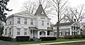
Homes in Dryden's historic district (2010)
|
|

Dryden, New York
Location in New York
|
|
| Country | United States |
| State | New York |
| County | Tompkins |
| Area | |
| • Total | 94.33 sq mi (244.31 km2) |
| • Land | 93.64 sq mi (242.53 km2) |
| • Water | 0.69 sq mi (1.79 km2) 0.31% |
| Population
(2020)
|
|
| • Total | 14,029 |
| • Estimate
(2021)
|
13,841 |
| • Density | 159.34/sq mi (61.52/km2) |
| Time zone | UTC-5 (Eastern (EST)) |
| • Summer (DST) | UTC-4 (EDT) |
| FIPS code | 36-109-20962 |
Dryden is a town in Tompkins County, New York, United States. It is home to about 14,000 people. The town includes two villages: one also called Dryden and another called Freeville. You'll find Dryden on the eastern side of Tompkins County, near Ithaca, in the beautiful Finger Lakes region.
Contents
History of Dryden
How Dryden Got Its Name
The land where Dryden is now was once part of the Central New York Military Tract. This was land given to soldiers who fought in the American Revolution. In 1790, a man named Robert Harpur named many towns in New York. He loved classical studies (ancient Greek and Roman writings). He named Dryden after John Dryden (1631–1700), a famous English poet. John Dryden translated many classic works, including those by Virgil. The nearby town of Virgil is also named after this connection!
Early Settlers and Changes
The first people settled in the Dryden area around 1797. The town of Dryden was officially created in 1803. It was formed from a larger town called Ulysses. Later, in 1856, a small part of Dryden was given to the growing village of Caroline, New York.
A Famous Document Sale
In 2009, something very exciting happened in Dryden. The Southworth Library sold an original speech written by Abraham Lincoln. He gave this speech at the White House after he was re-elected president. The library had owned this important document since 1926. It sold for $3.44 million, which was a record price for an American historical document at an auction!
Historic Places in Dryden
Two buildings in Dryden are listed on the National Register of Historic Places. This means they are important historical sites.
- The Dryden District School No. 5 was added to the list in 1984.
- The Ellis Methodist Episcopal Church was added in 1993.
Geography of Dryden
Land and Water
Dryden covers about 94.2 square miles (243.9 square kilometers). Most of this area is land, with a small part being water.
Neighboring Towns
Dryden shares its eastern border with Cortland County. The towns bordering Dryden are:
- Virgil, New York
- Harford, New York
- Caroline, New York
- Danby, New York
- Ithaca (town), New York
- Lansing (town), New York
- Groton (town), New York
Main Roads
Several important roads cross through Dryden:
- New York State Route 13 and New York State Route 38 meet in Dryden village.
- New York State Route 79 goes through the southwest part of town.
- New York State Route 366 crosses the middle part and meets NY-38 in Freeville.
- A small part of New York State Route 34B is in the northwest corner.
Rivers and Creeks
Several creeks flow through Dryden:
- Cascadilla Creek flows out of the west side.
- Fall Creek also flows out of the west side.
- Six Mile Creek is in the far southwest corner.
- Virgil Creek is a major stream that flows into Fall Creek in Freeville. It passes through the village of Dryden.
People of Dryden
| Historical population | |||
|---|---|---|---|
| Census | Pop. | %± | |
| 1820 | 3,951 | — | |
| 1830 | 5,206 | 31.8% | |
| 1840 | 5,446 | 4.6% | |
| 1850 | 5,122 | −5.9% | |
| 1860 | 4,962 | −3.1% | |
| 1870 | 4,818 | −2.9% | |
| 1880 | 4,805 | −0.3% | |
| 1890 | 4,043 | −15.9% | |
| 1900 | 3,785 | −6.4% | |
| 1910 | 3,590 | −5.2% | |
| 1920 | 3,186 | −11.3% | |
| 1930 | 3,534 | 10.9% | |
| 1940 | 3,947 | 11.7% | |
| 1950 | 5,006 | 26.8% | |
| 1960 | 7,353 | 46.9% | |
| 1970 | 9,770 | 32.9% | |
| 1980 | 12,156 | 24.4% | |
| 1990 | 13,251 | 9.0% | |
| 2000 | 13,532 | 2.1% | |
| 2010 | 14,435 | 6.7% | |
| 2020 | 14,029 | −2.8% | |
| 2021 (est.) | 13,841 | −4.1% | |
| U.S. Decennial Census | |||
Population Overview
In 2010, there were 14,435 people living in Dryden. There were over 6,000 households. The population density was about 153.9 people per square mile.
Diversity in Dryden
Most of the people in Dryden are White (93.7%). Other groups include Black or African American (4.2%), Native American (1.2%), and Asian (2.7%). About 3.1% of the population is Hispanic or Latino.
Age Groups
The population of Dryden includes people of all ages. About 28.3% are under 21 years old. About 11.3% are 65 years or older. The average age in Dryden is 37.6 years.
Education Levels
Many adults in Dryden have a good education. About 23.5% have a graduate or professional degree. Another 20.2% have a bachelor's degree. Many others have attended college or have a high-school diploma.
Communities and Locations in Dryden
The town of Dryden includes several smaller communities and interesting spots:
- Bethel Grove – A small community on NY-79 in the southwest.
- Dryden – The main village, located on NY-13.
- Dryden Lake – A small lake near the eastern border of the town.
- Dryden Lake Wildlife Management Area – A special area to protect wildlife near the eastern border.
- Ellis (or "Ellis Hollow") – A community in the southwest. The Ellis Methodist Episcopal Church here is a historic place.
- Etna – A community close to Ithaca.
- Freeville – A village located on NY-38.
- Hibbards Corners – A spot in the western part of the town.
- Howland Corners – A location on the western town line, on NY-34B.
- Lacy Corners – A community north of Dryden village.
- Malloryville – A location in the northeast part of Dryden.
- Peruton – A location near the northern town line.
- Red Mills – A community northeast of Freeville.
- Smith Corners – A location on the western town line, south of Howland Corners.
- Varna – A community near the western town line, on NY-366.
- West Dryden – A community in the northwest part of Dryden. The West Dryden Methodist Episcopal Church here is also a historic place.
- Willow Glen – A location west of Dryden village on NY-13.
Education in Dryden
Most students in Dryden attend schools in the Dryden Central School District. The main high school for this district is Dryden High School.
Other parts of Dryden are served by different school districts, including:
- Groton Central School District
- Lansing Central School District
- Ithaca City School District (whose high school is Ithaca High School)
Notable People from Dryden
- Cueball Carmichael, a professional wrestler, trainer, and promoter.
Images for kids
-
Homes in Dryden's historic district (2010)
See also
 In Spanish: Dryden (Nueva York) para niños
