
Elmore, Vermont facts for kids
Quick facts for kids
Elmore, Vermont
|
|
|---|---|

Along Lake Elmore in the town of Elmore
|
|

Elmore, Vermont
|
|

Elmore, Vermont
Location in the United States
|
|
| Country | United States |
| State | Vermont |
| County | Lamoille |
| Communities | East Elmore Lake Elmore |
| Area | |
| • Total | 39.7 sq mi (102.7 km2) |
| • Land | 39.1 sq mi (101.3 km2) |
| • Water | 0.5 sq mi (1.4 km2) |
| Elevation | 1,634 ft (498 m) |
| Population
(2020)
|
|
| • Total | 886 |
| • Density | 23/sq mi (8.7/km2) |
| Time zone | UTC-5 (Eastern (EST)) |
| • Summer (DST) | UTC-4 (EDT) |
| ZIP Codes | |
| Area code(s) | 802 |
| FIPS code | 50-23725 |
| GNIS feature ID | 1462089 |
Elmore is a small and friendly town located in Lamoille County, Vermont, in the United States. It was officially created by the Vermont Republic in 1780. The town got its name from Colonel Samuel Elmore (1720–1805), who was one of the first people to be given land there.
According to the 2020 census, about 886 people live in Elmore. The town includes the small communities of East Elmore and Lake Elmore. It is also home to Elmore State Park, a large area of 700-acre (2.8 km2) for outdoor fun. This park is found around the beautiful 219-acre (0.9 km2) Lake Elmore and on Elmore Mountain.
Contents
Exploring Elmore's Geography
Elmore is located in the southeastern part of Lamoille County. It shares its southern and eastern borders with Washington County. A small part of its eastern border also touches Caledonia County.
Land and Water Features
The town covers a total area of about 39.7 square miles (102.7 km2). Most of this area, about 39.1 square miles (101.3 km2), is land. The remaining 0.54 square miles (1.4 km2), which is about 1.38%, is water.
Lake Elmore is a key feature in the northwest part of the town. Water from Lake Elmore flows north through Elmore Pond Brook, eventually reaching the Lamoille River. The main village of Elmore is located at the northern end of the lake.
Mountains and Roads
The Worcester Mountains are found on the western side of Elmore. Mt. Elmore, which is at the northern end of this mountain range, rises to a height of 2,608 feet (795 m). It is located to the west of Lake Elmore.
Vermont Route 12 is an important road that goes through the town. It passes through Elmore village and runs along the eastern side of Lake Elmore. This highway connects Elmore to other towns. It leads northwest about 5 miles (8 km) to Morrisville and south about 21 miles (34 km) to Montpelier, which is the capital city of Vermont.
Elmore's Population Over Time
| Historical population | |||
|---|---|---|---|
| Census | Pop. | %± | |
| 1790 | 12 | — | |
| 1800 | 45 | 275.0% | |
| 1810 | 157 | 248.9% | |
| 1820 | 157 | 0.0% | |
| 1830 | 442 | 181.5% | |
| 1840 | 476 | 7.7% | |
| 1850 | 504 | 5.9% | |
| 1860 | 602 | 19.4% | |
| 1870 | 637 | 5.8% | |
| 1880 | 682 | 7.1% | |
| 1890 | 593 | −13.0% | |
| 1900 | 550 | −7.3% | |
| 1910 | 553 | 0.5% | |
| 1920 | 468 | −15.4% | |
| 1930 | 382 | −18.4% | |
| 1940 | 300 | −21.5% | |
| 1950 | 312 | 4.0% | |
| 1960 | 237 | −24.0% | |
| 1970 | 292 | 23.2% | |
| 1980 | 421 | 44.2% | |
| 1990 | 573 | 36.1% | |
| 2000 | 849 | 48.2% | |
| 2010 | 855 | 0.7% | |
| 2020 | 886 | 3.6% | |
| U.S. Decennial Census | |||
The population of Elmore has changed quite a bit over the years. When the first census was taken in 1790, only 12 people lived here! The number of residents grew steadily for many years.
By the year 2000, there were 849 people living in Elmore. The town had 306 households, and 223 of these were families. About 42.8% of the households had children under the age of 18 living with them.
The average age of people in Elmore in 2000 was 37 years old. About 29.8% of the population was under 18 years old. This shows that Elmore is a place where many families with children live.
Notable People from Elmore
Some interesting people have connections to Elmore. One well-known person is George W. Bailey Jr.. He was born in Elmore and later became the Secretary of State of Vermont. This is an important job in the state government.
Images for kids
-
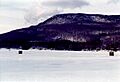
Ice fishing shanties on Lake Elmore, with Elmore Mountain rising behind

See also
 In Spanish: Elmore (Vermont) para niños
