
Emerald Peak (Washington) facts for kids
Quick facts for kids Emerald Peak |
|
|---|---|

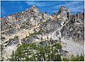
Emerald Peak, south aspect
|
|
| Highest point | |
| Elevation | 8,422 ft (2,567 m) |
| Prominence | 742 ft (226 m) |
| Isolation | 1.13 mi (1.82 km) |
| Parent peak | Cardinal Peak 8,595 ft |
| Geography | |

Emerald Peak
Location in Washington (state)

Emerald Peak
Location in the United States
|
|
| Location | Chelan County Washington, U.S. |
| Parent range | Chelan Mountains North Cascades Cascade Range |
| Topo map | USGS Saska Peak |
| Type of rock | hornblende quartz diorite, granodiorite |
| Climbing | |
| First ascent | 1937, William A. Long |
| Easiest route | class 2-3 scrambling |
Emerald Peak is a tall mountain in Washington state, standing at 8,422 ft (2,570 m) high. It's located in the Chelan Mountains within Chelan County. This amazing peak is part of the Glacier Peak Wilderness in the North Cascades, and it's cared for by the Wenatchee National Forest.
Emerald Peak is close to other important mountains. Its nearest higher peak is Cardinal Peak, which is about 1.1 mi (1.8 km) to the southeast. Another peak, Saska Peak, is about 0.66 mi (1.06 km) to the west-southwest. These three peaks are the highest in the Chelan Mountains. They surround the top part of the North Fork Entiat River valley.
Water from Emerald Peak flows into the Chelan River and Entiat River. The first time someone climbed to the very top of Emerald Peak was in 1937. This climb was made by William A. Long. Emerald Peak is the second-highest mountain in the Chelan Mountains. It is also the 70th-highest peak in all of Washington state.
Weather and Climate Around Emerald Peak
The weather near Emerald Peak is mostly affected by the Pacific Ocean. Most weather fronts, which are like big air masses that bring different weather, start over the Pacific. They then travel northeast towards the Cascade Mountains.
When these weather fronts reach the North Cascades, the tall peaks force the air upwards. As the air rises, it cools down and drops its moisture. This process is called Orographic lift. It causes a lot of rain or snow to fall on the Cascades. Because of this, the North Cascades get a lot of precipitation, especially heavy snowfall during winter.
In winter, the sky is usually cloudy. However, during summer, high-pressure systems over the Pacific Ocean become stronger. This often leads to clear skies with little or no cloud cover.
How Emerald Peak Was Formed
Emerald Peak is mainly made of two types of rock: granodiorite and hornblende quartz diorite. These rocks are part of a larger rock body called the Cardinal Peak pluton. The North Cascades area has very rugged land. You can see jagged peaks, tall spires, long ridges, and deep valleys carved by glaciers.
The different shapes of the land and the big changes in height across the Cascade Range happened over millions of years. These geological events also led to the different climates you find there. The Cascade Mountains started forming millions of years ago, during the late Eocene Epoch.
The North American Plate is a huge piece of Earth's crust that slowly moves. It has been sliding over the Pacific Plate. This movement caused many volcanic eruptions over time. For example, Glacier Peak, a large stratovolcano, began forming about 22.5 mi (36.2 km) west of Emerald Peak.
About 50 million years ago, small pieces of Earth's crust, called terranes, came together to create the North Cascades. Later, during the Pleistocene period (which started over two million years ago), huge sheets of ice called glaciers moved across the land. These glaciers advanced and then melted back many times. As they moved, they scraped the landscape, leaving behind piles of rock and debris.
The valleys in the area often have a "U" shape. This shape was created by the recent glaciers. The main forces that made the tall peaks and deep valleys in the North Cascades are the land being pushed upwards (uplift) and faulting (where rocks break and slide past each other), combined with the powerful action of glaciers.
Images for kids
-
A close-up view of the summit of Emerald Peak.

