Englewood, Ohio facts for kids
Quick facts for kids
Englewood, Ohio
|
|||
|---|---|---|---|

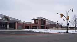
City Hall
|
|||
|
|||

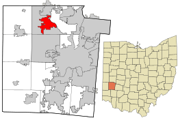
Location in Montgomery County and the state of Ohio.
|
|||
| Country | United States | ||
| State | Ohio | ||
| County | Montgomery | ||
| Founded | May 6, 1841 (as Harrisburg) | ||
| Named | "Iamton" February 8, 1870 "Englewood" July 11, 1899 |
||
| Incorporated | May 15, 1914 | ||
| Government | |||
| • Type | Council-Mayor | ||
| Area | |||
| • Total | 6.60 sq mi (17.10 km2) | ||
| • Land | 6.56 sq mi (16.99 km2) | ||
| • Water | 0.04 sq mi (0.11 km2) | ||
| Elevation | 958 ft (292 m) | ||
| Population
(2020)
|
|||
| • Total | 13,463 | ||
| • Estimate
(2023)
|
13,249 | ||
| • Density | 2,052.29/sq mi (792.36/km2) | ||
| Time zone | UTC-5 (EST) | ||
| • Summer (DST) | UTC-4 (EDT) | ||
| ZIP codes |
45315, 45322
|
||
| Area code(s) | 937, 326 | ||
| FIPS code | 39-25396 | ||
| GNIS feature ID | 2394692 | ||
| Website | www.englewood.oh.us | ||
Englewood is a city located in Montgomery County, Ohio, in the United States. In 2020, about 13,463 people lived there. It is a northern suburb of Dayton and is part of the larger Dayton metropolitan area.
Contents
History of Englewood
Early Settlers and Life
Even though Englewood was officially founded in 1841, people started settling in the area, then known as Randolph Township, around 1800. Some of the very first families to arrive included the Hoovers, Masts, Ewings, and McClintocks. Other early families were the Ellers, Foutses, and Brumbaughs.
These early settlers mostly made their living through agriculture, which means farming. They grew crops like grain and raised animals for bacon. They would ship these goods down the Stillwater River on flat boats. These boats traveled all the way to Dayton and even as far south as New Orleans.
Besides farming, there were also many small businesses. People built saw mills to cut wood. Some were gun smiths who made and fixed guns. Others made wine or created pottery.
In the early days, many Native Americans lived in the area. They often traded with the new settlers. The land also had lots of wildlife, which provided good hunting for the settlers' food.
Founding and Name Changes
A group of settlers followed the path of the Stillwater River and officially founded the community on May 6, 1841. These pioneers included Mathias Gish, Daniel Rasor, and Samuel Herr. Some of them came from near Harrisburg, Pennsylvania. Because of this, they named their new community Harrisburg. Other residents came from Randolph County, North Carolina, which is why the larger area was called Randolph Township.
Harrisburg got its first post office on February 8, 1870. It closed for a short time but reopened on May 8, 1874. Harvey Iams was the first postmaster. The town was then renamed Iamton after him. However, back then, the letters "I" and "J" looked very similar. So, the town became commonly known as Jamton.
In 1898, local business owners held a contest to pick a new name for the town. The name Englewood was chosen as the winner. So, Jamton officially became Englewood. The Village of Englewood was officially made a village on May 15, 1914. Jacob Hoover became its first mayor.
The population of Englewood grew steadily. By 1930, about 415 people lived there. By 1940, it had grown to over 600 people. Englewood officially became a city in 1971.
Modern Services
Over the years, Englewood gained important services. Natural gas became available to homes and businesses in 1934. The first water works (a system for providing water) was built in 1936. The original sewer system was finished in 1940.
Geography and Location
Englewood is located along the Stillwater River. It shares borders with other cities like Clayton and Union. It also borders Butler Township.
Major roads cross through Englewood. Interstate 70 and the historic National Road (U.S. Route 40) meet Ohio State Route 48 within the city's boundaries.
According to the United States Census Bureau, Englewood covers a total area of about 6.59 square miles (17.10 square kilometers). Most of this area, about 6.55 square miles (16.99 square kilometers), is land. A small part, about 0.04 square miles (0.11 square kilometers), is water.
Population and People
| Historical population | |||
|---|---|---|---|
| Census | Pop. | %± | |
| 1920 | 351 | — | |
| 1930 | 415 | 18.2% | |
| 1940 | 531 | 28.0% | |
| 1950 | 678 | 27.7% | |
| 1960 | 1,515 | 123.5% | |
| 1970 | 7,885 | 420.5% | |
| 1980 | 11,329 | 43.7% | |
| 1990 | 11,432 | 0.9% | |
| 2000 | 12,235 | 7.0% | |
| 2010 | 13,465 | 10.1% | |
| 2020 | 13,463 | 0.0% | |
| 2023 (est.) | 13,249 | −1.6% | |
| Sources: | |||
Population in 2010
The census from 2010 showed that 13,465 people lived in Englewood. There were 5,555 households, which are like homes or families living together. Out of these, 3,687 were families.
The population density was about 2,055.7 people per square mile (793.7 people per square kilometer). This means how many people live in a certain area. There were also 5,898 housing units, which are places where people can live.
Most of the people in Englewood were White (82.3%). About 12.9% were African American. Smaller groups included Asian (1.6%), Native American (0.2%), and Pacific Islander (0.1%). About 2.3% of people were from two or more races. People who identified as Hispanic or Latino made up 1.1% of the population.
Households and Age
About 31% of the households had children under 18 living with them. More than half (50.6%) were married couples living together. About 12% had a female head of the house with no husband present. A small number (3.8%) had a male head of the house with no wife present. The rest (33.6%) were non-family households.
About 29.4% of all households were made up of just one person. And 12.6% had someone living alone who was 65 years old or older. The average household had 2.37 people, and the average family had 2.93 people.
The average age of people in Englewood was 42.1 years old. About 23% of residents were under 18. About 6.9% were between 18 and 24. People aged 25 to 44 made up 23.7% of the population. Those aged 45 to 64 were 27.1%. And 19.2% of residents were 65 years old or older. The city had slightly more females (53.4%) than males (46.6%).
Education in Englewood
Englewood is part of the Northmont City School District. This district serves students in Montgomery County, Ohio.
The schools in the district include:
- Northmont High School
- Northmont Middle School
- Englewood Hills Elementary
- Northmoor Elementary
- Northwood Elementary
- Union Elementary
- Kleptz Early Learning Center
Englewood also has a public library. It is a branch of the Dayton Metro Library.
See also
 In Spanish: Englewood (Ohio) para niños
 | Valerie Thomas |
 | Frederick McKinley Jones |
 | George Edward Alcorn Jr. |
 | Thomas Mensah |


