Yellowhead County facts for kids
Quick facts for kids
Yellowhead County
|
|
|---|---|

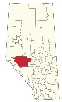
Location within Alberta
|
|
| Country | Canada |
| Province | Alberta |
| Region | Central Alberta |
| Census division | 14 |
| Established | 1994 |
| Incorporated | 1994 |
| Area
(2021)
|
|
| • Land | 22,238.56 km2 (8,586.36 sq mi) |
| Population
(2021)
|
|
| • Total | 10,426 |
| • Density | 0.5/km2 (1/sq mi) |
| Time zone | UTC−7 (MST) |
| • Summer (DST) | UTC−6 (MDT) |
Yellowhead County is a special type of local government area called a municipal district. It's located in the west-central part of Alberta, Canada. It is the only municipal district in its area, known as Census Division No. 14.
Contents
A Look at Its History
Yellowhead County has an interesting past. It was first created on January 1, 1994. Back then, it was known as the Municipal District of Yellowhead No. 94.
Just a few years later, on July 8, 1998, its name officially changed to Yellowhead County. In the same year, a small village called Evansburg joined the municipal district. This happened on June 30, 1998.
Where is Yellowhead County?
Yellowhead County is a large area in Alberta. It includes many different communities. Some of these are towns, while others are smaller places called hamlets or localities.
Towns and Hamlets
The following urban municipalities are surrounded by Yellowhead County:
The following hamlets are located within Yellowhead County:
- Hamlets
Localities in Yellowhead County
|
Yellowhead County is also home to many smaller places called localities. These include: |
|
|
The former Village of Tollerton is also located in Yellowhead County.
Who Lives Here?
We can learn about the population of Yellowhead County from official counts called a census. In 2021, Statistics Canada counted 10,426 people living in Yellowhead County. These people lived in 4,160 homes.
This number is a little lower than the population in 2016, which was 10,995 people. The county covers a very large land area of about 22,238.56 square kilometers. This means there are not many people living in each square kilometer. This is called the population density.


