Farringdon, London facts for kids
Quick facts for kids Farringdon |
|
|---|---|
| OS grid reference | TQ315818 |
| London borough | |
| Ceremonial county | Greater London |
| Region | |
| Country | England |
| Sovereign state | United Kingdom |
| Post town | LONDON |
| Postcode district | EC1 |
| Dialling code | 020 |
| Police | Metropolitan |
| Fire | London |
| Ambulance | London |
| EU Parliament | London |
| UK Parliament |
|
| London Assembly |
|
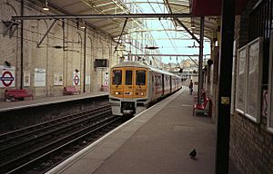
Farringdon is a small area in Central London. It is located in the southern part of the London Borough of Islington. When people talk about Farringdon, they usually mean the area around Farringdon station.
Historically, this area was part of southern Clerkenwell. It also included a small parish called St Sepulchre Middlesex.
The name "Farringdon" actually comes from the station. The station was named after Farringdon Street. To the south of this area are two City of London wards called Farringdon Within and Farringdon Without. These City wards were once one big area. They are not directly connected to the Farringdon district to their north, but they share a similar name origin.
Contents
What Does Farringdon Mean?
There are many places in England named Farringdon. The name usually means fern covered hill.
Two important citizens and Aldermen in the early 1200s were William and Nicholas de Faringdon. Their name likely came from one of these "fern covered hill" places. Nicholas bought the land that became the Farringdon ward in the City of London in 1279. He became its Alderman in 1281. In 1394, this ward was split into two parts: Farringdon Within and Farringdon Without. These two parts still exist today.

Farringdon Station's History
Farringdon Station was built near Farringdon Road. This road is a northern extension of Farringdon Street, which is outside the City of London. When the station first opened in 1863, it was called Farringdon Street Station.
Farringdon Street itself was built over the River Fleet in 1737. It was named either after the Farringdon Wards in the City or in honor of Nicholas de Faringdon. The road was made wider in 1829.
Before the street was built, this area was home to Farringdon Market. This market sold fruit and vegetables. It opened on November 20, 1826, after the older Fleet Market was cleared away. The station was renamed Farringdon & High Holborn in 1922. Finally, it became simply Farringdon in 1936.
City of London Wards
In the City of London, there are two wards named Farringdon: Farringdon Within and Farringdon Without. This happened because the original Farringdon Ward was split in 1394.
"Without" means outside the London Wall, and "Within" means inside the wall. This was also true for other wards like Bridge Within and Bridge Without. These Farringdon wards cover a large part of the City.
Before 2004, these wards were even bigger. Farringdon Without stretched from Chancery Lane to Smithfield. It included areas like Middle Temple and Inner Temple. Farringdon Within covered the area inside the walls, including Blackfriars and St Bartholomew's Hospital.
In 2003, the City's wards were reviewed. Some parts of Farringdon Without were moved to Castle Baynard Ward. This included areas north and south of Fleet Street. A small "corridor" still connects the western part along Holborn to Smithfield. Also, parts of Farringdon Within were moved to Bassishaw Ward and Castle Baynard.
A map from around 1600 shows the Fagswell Brook south of Cowcross Street. This brook was the northern border of the City.
Until 1993, a small piece of land south of Cowcross Street was part of the City of London. It belonged to the Farringdon Without ward. In 1993, the border between the City of London and the London Borough of Islington was changed. The border in this area moved slightly south to line up with Charterhouse Street.
Farringdon Today
The exact size of the area called Farringdon today is not strictly defined. People often use the name to refer to the area around Farringdon station. This is similar to how people use the name "Victoria" for the area around Victoria Station.
Farringdon Station and its nearby surroundings are at the very southern tip of Clerkenwell. This is in the London Borough of Islington. It is also very close to the northern border of the City of London and the eastern border of the London Borough of Camden. The station and its area used to be in the Metropolitan Borough of Finsbury. Now, they are part of the London Borough of Islington.
Transport and Future Plans
Farringdon Station is a very important transport hub. It is currently served by the Thameslink north-south train route. This route connects places from north to south across London.
There are big plans to improve and expand Farringdon Station. A new east-west train service called the Elizabeth Line will also stop here. This new line will need more station entrances to be built. The Elizabeth Line was planned to open in December 2018, but it opened in 2022.
An upgrade to the Thameslink route is also planned. This will also affect the local area. It includes building more station entrances. Cowcross Street might become a pedestrian-only street, meaning no cars. Some buildings might also be taken down to make way for these changes.
The Farringdon area is part of the City Fringe Partnership. This is a project between the City of London and other local councils. Their goal is to improve parts of Inner London that are right next to the City. In 2008, a plan to greatly redevelop the area was rejected. This plan included taking down part of Smithfield Market.
 | Tommie Smith |
 | Simone Manuel |
 | Shani Davis |
 | Simone Biles |
 | Alice Coachman |


