
Fichtel Mountains facts for kids
Quick facts for kids Fichtel Mountains |
|
|---|---|
| Fichtelgebirge / Smrčiny | |

The Schneeberg (left) and the Ochsenkopf (right), seen from Heinersreuth
|
|
| Highest point | |
| Peak | Schneeberg |
| Elevation | 1,051 m above NN |
| Geography | |

The Fichtel Mountains in northeast Bavaria
|
|
| State | Bavaria & Czech Republic |
| Range coordinates | 50°03′N 11°51′E / 50.05°N 11.85°E |
| Parent range | Thuringian-Franconian Highlands |
The Fichtel Mountains (called Fichtelgebirge in German and Smrčiny in Czech) are a small mountain range in northeastern Bavaria, Germany. They look a bit like a horseshoe! These mountains stretch from the Red Main River valley all the way to the border with the Czech Republic, with some parts even crossing into the Czech Republic. To the northeast, they connect with the Elster Mountains, and to the southeast, with the Upper Palatine Forest. A big part of the Fichtel Mountains is a special protected area called the Fichtel Mountain Nature Park, which covers about 1,020 square kilometers (390 sq mi).
Contents
- What's in a Name? The Fichtel Mountains' Story
- Where are the Fichtel Mountains?
- How the Fichtel Mountains Look: Shapes and Rivers
- How the Mountains Were Formed: A Geological Story
- Mining in the Fichtel Mountains
- Fun Traditions
- Economy and Tourism: What People Do Here
- Towns and Villages in the Fichtel Mountains
- How to Get There
- See also
What's in a Name? The Fichtel Mountains' Story

The name "Fichtel Mountains" has an interesting history. The first person to write about them was Matthias of Kemnath in 1476. He mentioned "a mountain, high, wide and well-known, in Bavaria, called the Fichtelberg."
Later, in 1499 and 1536, the mountain we now call the Ochsenkopf was known as Vichtelberg. Over time, this name grew to include the entire mountain region. Old documents from around 1317 also talk about the "walt zu dem Vythenberge," which means "forest at the Vyth mountain." It seems the name might come from "St. Veith," a pit where iron ore was mined on the mountain's southern side in the 14th century. So, Vyth became Veit, and then Fichtel.
Some people think the name Fichtelgebirge comes from the German word Fichte, which means "spruce tree." However, this is probably not true. When the name became popular, the forests in the area didn't have many spruce trees.
Where are the Fichtel Mountains?

The Fichtel Mountains are located between the towns of Hof and Weiden. If you're coming from the west, it's easy to reach them from the city of Bayreuth.
The main town in the heart of the Fichtel Mountains is Wunsiedel. It's famous for its amazing Luisenburg Rock Labyrinth. Other important towns nearby include Marktredwitz, Marktleuthen, Arzberg, Weißenstadt, and Kirchenlamitz. The biggest town on the Czech side of the Fichtel Mountains is Aš.
The Fichtel Mountains are also home to a mix of different German dialects. The border between the East Franconian dialect and the North Bavarian dialect runs right through the mountains. This means you might hear different ways of speaking even in towns that are close to each other! After World War II, many people from other parts of Europe, like Bohemia and Silesia, moved to the Fichtel Mountains, adding to the region's unique culture.
How the Fichtel Mountains Look: Shapes and Rivers


The Fichtel Mountains are shaped like a horseshoe, made up of several connected ridges. This is why people sometimes call them the "Fichtel Mountain Horseshoe." The most important parts are:
- The High Fichtel with mountains like the Schneeberg, Ochsenkopf, and Kösseine.
- The Northern ridge, which includes the Waldstein, Epprechtstein, and Kornberg mountains.
- The Southern section with its Steinwald and Reichsforst forests, and the Kohlberg mountain.
- The Inner Fichtel Plateau, which is a flatter area inside the horseshoe.
The Fichtel Mountains are sometimes called the "navel of Germany" or the "wellspring of Europe." This is because four important rivers start here and flow in different directions:
- The Saxon Saale flows north.
- The Ohře (also called Eger) flows east.
- Two parts of the Naab river, the Fichtelnaab and the Haidenaab, flow south.
- The White Main flows west.
Many protected marshy areas in the mountains collect water, which is very important. The European watershed, which separates rivers flowing to the North Sea from those flowing to the Black Sea, runs right over these mountains.
Highest Peaks and Famous Mountains
The highest mountain in the Fichtel Mountains is the Schneeberg, standing at 1,051 meters (3,448 ft) tall.
The Ochsenkopf ("Ox Head") is the second highest mountain, at 1,024 meters (3,360 ft). You can take a chair-lift to the top from either Bischofsgrün or Fleckl. At the summit, there's an observation tower called the "Asenturm" and a restaurant.
Here are some of the highest and most famous mountains in the Fichtel Mountains:
| Mountain | Height (m) | What's Special About It |
|---|---|---|
| Schneeberg | 1,051 | Was a listening post during the Cold War |
| Ochsenkopf | 1,024 | Has two chair-lifts to the top |
| Nußhardt | 972 | |
| Platte (Steinwald) | 946 | |
| Kösseine | 939 | |
| Großer Waldstein | 877 | |
| Hohberg (Königsheide) | 863 | |
| Großer Kornberg | 827 | |
| Hohe Matze | 813 | |
| Epprechtstein | 798 | |
| Háj | 758 | The highest mountain on the Czech side |
| Fürstenstein | 675 | |
| Kohlberg | 632 |
How the Mountains Were Formed: A Geological Story


The Fichtel Mountains are mostly made of a type of rock called granite. The story of how they were formed began a very long time ago, about 750-800 million years ago! Back then, there were huge mountains, but over millions of years, they wore down.
Later, the area was covered by the sea. Rivers carried sand, clay, and other materials into the sea, which settled in layers. Around 570 million years ago, these layers were squeezed and pushed up to form new mountains. This process, called mountain folding, lasted for a very long time. During this time, the heat and pressure turned some rocks into new types, like phyllite and schist from clay, and quartzite from sandstone. Even limestone became Wunsiedel marble. These mountains were also worn down by nature over time.
The Variscan Orogeny: Mountains from Deep Below
The next big event happened about 285 million years ago. This was a huge mountain-building period called the Variscan orogeny. During this time, the Fichtel Mountains, along with other areas, were pushed up high. At the same time, hot, melted rock (magma) pushed its way up into the folds of the mountains. This magma cooled and hardened underground, forming the granite we see today.
This process also created valuable minerals and ores, which were important for mining in the Middle Ages.
New Pressures from the Alps
Much later, about 26 million years ago, the Earth's crust became active again. This was linked to the formation of the huge Alps mountain range. During this time, some parts of the Fichtel Mountains were pushed up again. About 10 million years ago, melted rock called basalt broke through the surface, forming features like the Rauher Kulm.
The landscape we see today was mostly shaped about 5 million years ago. An old fault line (a crack in the Earth's crust) became active again, lifting the Fichtel Mountains even higher. Rivers then cut deep valleys into the mountains, creating the unique landscape we know today. This long and exciting geological history makes the Fichtel Mountains a fascinating place for geologists!
Types of Rock You'll Find
Granite is the most common rock in the Fichtel Mountains, making up about 40% of the area. It's a very hard rock that forms the highest peaks. Its strong appearance and the early industries that used it have shaped both the landscape and the people living here.
There are many different types of granite in the Fichtel Mountains, each with its own look and feel. For example:
- Porphyritic Granite has large crystals of feldspar (a mineral) that can be up to 8 cm long!
- Reut Granite is finer and has a bluish-grey color.
- Redwitzite can be light grey, dark grey, or even dark green-grey, depending on its minerals.
- Kern Granite forms many of the interesting rock formations you can see.
- Zinn Granite is very even and lighter in color.
These different types of granite, along with other rocks like phyllite and marble, tell the story of the Fichtel Mountains' long geological journey.
Mining in the Fichtel Mountains
People started mining in the Fichtel Mountains way back in the Early Middle Ages. They dug for important things like gold, tin, iron, and various minerals and rocks. The forests provided wood to make charcoal, which was needed for processing the metals.
During the Thirty Years' War, mining slowed down, and many of the ore deposits were used up. In the 18th century, a famous scientist named Alexander von Humboldt tried to bring mining back to life. Many towns and villages in the area, like Wunsiedel and Goldkronach, grew because of the mining industry.
If you want to learn more about the history of mining here, you can visit:
- The visitor mine of Gleissinger Fels near Fichtelberg-Neubau.
- The gold mining museum in Goldkronach.
- The mining exhibition in the Fichtelgebirge Museum at Wunsiedel.
Fun Traditions
The Huguenots, who were French Protestants, brought a lovely tradition to the Fichtel Mountains: decorating wells for Easter! These "Osterbrunnen" (Easter wells) are decorated with colorful eggs and ribbons, often including the lily, which was a symbol of French kings. It's a beautiful sight to see in the spring!
-
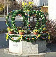
Easter well in Marktleuthen
-
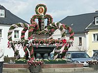
Easter well in Weißenstadt


Economy and Tourism: What People Do Here
The Fichtel Mountains are known for making beautiful things. Many places still produce glassware, and the porcelain industry, especially around the town of Selb, is famous worldwide. Companies like Rosenthal and Hutschenreuther are well-known for their high-quality porcelain.
Today, tourism is a very important part of the economy. Many towns, like Bischofsgrün, have been popular holiday spots since the 1920s. After World War II, even more people came to visit, both in summer for hiking and in winter for sports. The Fichtel Mountains became a favorite place for people from West Berlin to vacation.
The Fichtel Mountains are a great place for winter sports. There are several lifts, including two chair lifts on the Ochsenkopf, and many trails for cross-country skiing. In the warmer months, people enjoy mountain biking, hiking, and exploring the many large rock formations.
Towns and Villages in the Fichtel Mountains

- Arzberg
- Aš
- Bad Berneck
- Bindlach
- Bischofsgrün
- Brand (Oberpfalz)
- Ebnath
- Erbendorf
- Fichtelberg
- Gefrees
- Goldkronach
- Hazlov
- Höchstädt im Fichtelgebirge
- Hranice
- Kemnath
- Krásná
- Kirchenlamitz
- Luby
- Marktleugast
- Marktleuthen
- Marktredwitz
- Marktschorgast
- Mehlmeisel
- Münchberg
- Nagel
- Neusorg
- Plesná
- Podhradí
- Rehau
- Röslau
- Schirnding
- Schönbrunn
- Schönwald
- Selb
- Skalná
- Sparneck
- Speichersdorf
- Thiersheim
- Thierstein
- Tröstau
- Waldershof
- Warmensteinach
- Weidenberg
- Weißdorf
- Weißenstadt
- Wunsiedel
- Zell im Fichtelgebirge
How to Get There
- By Train: You can reach Marktredwitz station by train from places like Eger, Regensburg, Nuremberg, Munich, Hof, Bayreuth, Dresden, and Leipzig.
- By Road: Major roads like the B 303 and B 15 lead to the Fichtel Mountains. You can also use motorways like the A 93 and A 9.
- By Air: The closest airport is Hof-Plauen Airport.
See also
 In Spanish: Fichtelgebirge para niños
