Fire Island (Anchorage, Alaska) facts for kids

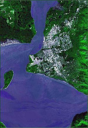
Fire Island is a long island in Alaska, located near the top of Cook Inlet. It's about 5.5 miles (9 km) long. This island is the only one in the Municipality of Anchorage. It sits about three miles (5 km) from Point Campbell in the city, and nine miles (14.5 km) from downtown Anchorage. The island is quite large, covering about 6.7 square miles (17.5 km²). No one lived there permanently during the 2000 census.
Contents
Island Features and Nature
Fire Island is made of layers of rock, covered by deep sand and gravel from the nearby tidal waters. The island has steep cliffs, usually about 60 meters (200 feet) high. The land itself is between 25 and 90 meters (82 and 295 feet) above sea level. When the tide is low, you can sometimes walk across the muddy areas of the Cook Inlet to reach Fire Island. However, this can be very dangerous because the tide comes in quickly, and people have drowned trying to cross.
The island has many forests, similar to those found in Interior Alaska. You can also find bogs, which are wet, spongy areas, in low-lying spots where water doesn't drain well. Small areas of tidal marshes and salt grasses grow on the west and northeast sides. There isn't much fresh water on Fire Island. It only has a few small lakes, and the underground water can easily mix with saltwater from the ocean.
A Look Back: Fire Island's History
The native Dena’ina people called the island Nutuł’iy, which means "object that stands in the water." Europeans first saw the island when Captain Cook explored the area now known as Cook Inlet. Cook's crew landed on the island and named it "Currant Island." Later, in 1794, George Vancouver called it "Turnagain Island" because it faces the Turnagain Arm. By 1895, the name "Fire Island" became official.
An elder from the Dena’ina people once said that a village used to be on Fire Island. But a sickness forced the people who survived to move to Point Possession on the Kenai Peninsula before 1934. Even so, Dena’ina families used Fire Island for fishing camps from 1918 until the 1970s. For many years, from 1909 to 1955, the island was set aside as a special place for Alaska moose to breed. During World War II, the U.S. Army used Fire Island as a lookout point to watch for Japanese submarines.
Fire Island Air Force Station
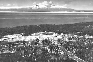
In September 1951, the U.S. Air Force built a base on the southern end of the island. It was called Fire Island Air Force Station. About 200 people worked there. The base was a radar center for air defense and a site for Nike surface-to-air missiles. It also helped the Federal Aviation Administration (FAA) with air traffic control and communications.
Since Fire Island isn't connected to the mainland, all supplies came by helicopter from Elmendorf Air Force Base. In the summer, supplies also arrived by barge from Anchorage. A runway was built for planes in the early years of the base. However, during the huge 1964 Alaska earthquake, the airfield sank into the ocean. After that, helicopters were the only way to reach the island by air.
Fire Island Air Force Station closed in 1969. The FAA was the only group left using the island. In the 1990s, the old base site was cleaned up, and its buildings were torn down. The FAA site stayed open until 1980, when new radar in Kenai became active. In 1982, the land where the air station used to be was given to Cook Inlet Region, Inc. (CIRI), a native corporation.
Today, CIRI owns most of Fire Island (90% of its 4,000 acres). The rest belongs to the FAA and the U.S. Coast Guard. The FAA still has a small airfield on the east side of the island. It has two runways and sees about 25 plane landings and takeoffs each month. You need special permission to visit the island.
Fire Island's Wind Farm
Today, Fire Island is home to a wind farm! It has 11 wind turbines that can produce 17.6 megawatts of power. This wind farm is owned and run by Fire Island Wind LLC, which is part of CIRI, the island's owners. The top part of each turbine, called the nacelle, is about 262 feet (80 meters) above the ground. That's as tall as the Robert B. Atwood Building in Anchorage, which is the city's second-tallest building. An underwater power line connects the wind farm to Anchorage's electricity grid.
This wind farm is the first large-scale wind project in Southcentral Alaska. The company says it provides enough electricity to power 5,600 homes in Anchorage. The FAA currently allows only 11 turbines, but the farm could become three times bigger, with up to 33 turbines in the future.
How the Wind Farm Project Started
After the air force station closed, people suggested different uses for Fire Island. Some thought about expanding the Port of Anchorage or building factories. Even though there wasn't enough drinking water for big businesses, in the early 1990s, Chugach Electric, a power company, realized Fire Island would be a great spot for a wind farm. They chose it because of its strong, steady winds, its closeness to Anchorage, and because there weren't other big plans for the land.
In 2000, Chugach Electric asked CIRI, the island's owners, if they would build a wind farm and sell the electricity to Anchorage. Over the next few years, measurements confirmed that the island was perfect for making wind power. The FAA, which runs the nearby Anchorage International Airport, carefully approved the project in 2008. They decided the wind turbines wouldn't cause problems with their radar equipment.
Work on the wind farm began in 2009. The turbines themselves were built during the summer of 2012. On September 24, 2012, all 11 turbines started sending electricity to the Anchorage power grid.
 | James Van Der Zee |
 | Alma Thomas |
 | Ellis Wilson |
 | Margaret Taylor-Burroughs |


