
Forel, Vaud facts for kids
Quick facts for kids
Forel
|
||
|---|---|---|
 |
||
|
||

Forel
Location in Switzerland

Forel
Location in Canton of Vaud
|
||
| Country | Switzerland | |
| Canton | Vaud | |
| District | Lavaux-Oron | |
| Area | ||
| • Total | 18.51 km2 (7.15 sq mi) | |
| Elevation | 723 m (2,372 ft) | |
| Population
(Dec 2020 )
|
||
| • Total | 2,107 | |
| • Density | 113.83/km2 (294.82/sq mi) | |
| Demonym(s) | Les Forellois | |
| Postal code |
1072
|
|
| Surrounded by | Cully, Epesses, Essertes, Grandvaux, Les Cullayes, Les Tavernes, Puidoux, Riex, Savigny, Servion, Villette, Vuibroye | |

Forel is a town in Switzerland. It is located in the Vaud area, specifically in the Lavaux-Oron district. Forel is known as a "municipality," which is like a local government area.
Contents
A Look at Forel's Past
Forel has a long history! The first time the area was written about was in 1140. An old document mentioned that the Bishop of Lausanne owned land near the Lac de Joux Abbey. The forests of Forel were first named "Fores" in 1274. By 1300, it was called "Forel."
In 1298, two people named Pierre and Garnier de Palézieux bought a small part of Forel and its forests. Two years later, the land was sold to the Bishop of Lausanne. It then became part of a bigger area called the Grande Paroisse de Villette.
After 1536, the area came under the control of Bern, another Swiss region. Forel was part of a new district called Place General de Villette. It wasn't until 1601 that a representative from Forel was allowed to join the local council in Cully. People in Forel had to pay many taxes, including old-fashioned taxes called "tithes" on their crops and animals.
From 1798 to 1803, Forel was part of a new government called the Helvetic Republic. Then it became part of the Vaud area. For a long time, until 1824, Forel was part of a larger town called Villette. People in Forel really wanted their own local government.
In 1824, the government agreed to divide Villette into smaller towns, and Forel became its own municipality. The first local council meeting for Forel happened on December 14, 1826.
Where is Forel?
Forel is located about 716 meters (2,349 feet) above sea level. It's about 11 kilometers (7 miles) east of Lausanne, a major city in the canton of Vaud. The town is spread out in a high area called the Jorat plateau.
Forel covers an area of about 18.51 square kilometers (7.15 square miles). A large part of this land, about 64.2%, is used for farming. Forests cover about 27.6% of the area. The rest of the land, about 7.8%, has buildings or roads. There are also small areas of rivers and unproductive land.
The Grenet River flows through the area and helps form the town's natural border. To the north, you'll find the Bois du Grand Jorat forest, which reaches up to 884 meters (2,900 feet) high. To the south, the land goes up to the wooded Mont de Gourze, which is 925 meters (3,035 feet) high. This is the highest point in the area.
Forel is made up of its main center and many smaller villages and settlements. These include Le Pigeon, Le Plan, Le Grenet, Les Chesaudes, and La Tuilière. Many individual farms are also scattered around. Forel is surrounded by several other towns, like Puidoux, Epesses, and Savigny.
Forel's Coat of Arms
The official symbol, or coat of arms, of Forel is red. It shows a white letter "F" (for Forel) between two white deer antlers.
People of Forel
Forel (Lavaux) has a population of about 2,200 people. Around 15% of the people living in Forel are from other countries. Over the last 10 years, the population has grown by about 13%. This growth is due to both new births and people moving into the area.
Most people in Forel (about 92%) speak French. German is the second most common language, spoken by about 3.3% of the population. A small number of people also speak Portuguese or Italian.
In 2000, about 28.6% of the people in Forel were born there. Another 38.4% were born in the same canton (Vaud). About 13.6% were born in other parts of Switzerland, and 16.4% were born outside of Switzerland.
The age groups in Forel are quite balanced. About 12.5% of the population are children under 9 years old. Teenagers (10-19 years old) make up about 11.7%. Adults between 30 and 49 years old make up a larger portion, around 32%. Older adults (60 and above) make up about 20% of the population.
Most households in Forel have an average of 2.5 people. About 26% of households are made up of just one person. Many households are married couples, some with children and some without.
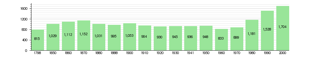
The number of people living in Forel has changed over time. You can see how the population has grown and shrunk in the chart below:
Forel's Economy
For a long time, Forel was mainly a farming village. Farming, dairy production, raising animals, and forestry were very important jobs. Today, these jobs still employ about 33% of the people.
Since the 1970s, a business area has grown in Forel. Companies there work in construction and information technology. There's even a company that makes kitchen appliances! Many new homes have been built, making Forel a place where people live and then travel to work. Many people who live in Forel commute to jobs in Lausanne and the Vevey-Montreux area.
In 2010, the unemployment rate in Forel was 3.3%. This means a small percentage of people who wanted jobs couldn't find them. Many people in Forel work in different types of jobs:
- Primary sector: These are jobs that get raw materials, like farming or forestry.
- Secondary sector: These are jobs that make things, like manufacturing or construction.
- Tertiary sector: These are service jobs, like sales, transportation, hotels, or healthcare.
In 2008, there were 512 full-time jobs in Forel. About 84 jobs were in farming and forestry. About 239 jobs were in making things, like manufacturing (46%) and construction (54%). The rest, 189 jobs, were in services. These included sales, transportation, hotels, and healthcare.
Many people who live in Forel travel outside the town for work. In 2000, about 68.8% of workers used a private car to get to work. About 9.7% used public transportation.
Politics in Forel
In the 2007 federal election, the most popular political party in Forel was the SVP. They received 25.4% of the votes. Other popular parties included the LPS Party, the FDP, and the SP. About 46.6% of the people who could vote did vote in that election.
Religion in Forel
Based on a census in 2000, most people in Forel belong to a Christian church. About 22.1% were Roman Catholic. A larger group, about 54.4%, belonged to the Swiss Reformed Church.
There were also smaller numbers of people who belonged to other Christian churches, like the Eastern Orthodox Church. A very small number of people were Jewish or Islamic. About 14.6% of the population said they didn't belong to any church or were agnostic or atheist.
Education in Forel
Many people in Forel have a good education. About 37.3% of the population have finished high school. About 12.4% have gone on to higher education, like a university or a specialized college.
In the 2009/2010 school year, there were 217 students in the Forel school district. In the Vaud area, children can go to two years of optional pre-school. The canton's primary school program lasts for four years. Forel had 136 students in primary school. The required middle school program lasts for six years, and there were 81 students in those schools.
In 2000, 46 students came to Forel to go to school from other towns. At the same time, 150 students from Forel went to schools outside the town.
Getting Around Forel
Forel has good transportation connections. It is located on the main road that goes from Moudon to Vevey. Another road, connecting Lausanne to Oron-la-Ville, also crosses here. The closest major highway, the A9 road, was built in 1974. It connects Lausanne to Sion. You can also get around Forel using bus line 65.
See also
 In Spanish: Forel (Lavaux) para niños
