
Four Brothers (Cascade Range) facts for kids
Quick facts for kids Four Brothers |
|
|---|---|

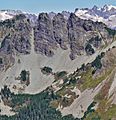
Four Brothers, east aspect
|
|
| Highest point | |
| Elevation | 6,485 ft (1,977 m) |
| Prominence | 205 ft (62 m) |
| Isolation | 0.73 mi (1.17 km) |
| Parent peak | Chikamin Peak (7,000+ ft) |
| Geography | |

Four Brothers
Location in Washington (state)

Four Brothers
Location in the United States
|
|
| Parent range | Cascade Range |
| Topo map | USGS Chikamin Peak |
| Climbing | |
| Easiest route | class 2 Southwest slope |
Four Brothers is a mountain peak in Kittitas County, Washington state. It stands 6,485 feet (1,977 meters) tall. This mountain is part of the beautiful Alpine Lakes Wilderness area. It is managed by the Wenatchee National Forest, which is part of the larger Cascade Range mountains.
Four Brothers is about 4 miles (6.4 km) northeast of Snoqualmie Pass. It sits on Chikamin Ridge, not far from its taller neighbor, Chikamin Peak. The famous Pacific Crest Trail (PCT) goes right past Four Brothers. It crosses the west side of the mountain and then the east side, near Three Queens.
The mountain got its name in the 1890s. It was named after four brothers: John, Tom, Vic, and Lawrie Denny. They were miners who lived in a cabin at the base of these four peaks. Water from the mountain flows into the Yakima River basin. It drains west into Gold Creek or east into Glacier Lake.
Mountain Weather

Four Brothers is located in a "marine west coast" climate zone. This means it gets a lot of moisture from the Pacific Ocean. Most weather fronts move from the Pacific Ocean towards the Cascade Range.
When these weather fronts hit the tall Cascade Mountains, they are forced to rise. As the air rises, it cools down and drops its moisture. This causes a lot of rain or snowfall on the west side of the Cascades. This process is called Orographic lift.
During winter, the weather is often cloudy with lots of snow. But in summer, high-pressure systems over the Pacific Ocean bring clear skies. This means there's usually little or no cloud cover during the warmer months.
Mountain History and Formation
The Alpine Lakes Wilderness area has very rugged land. You can see sharp peaks, long ridges, deep glacial valleys, and huge granite walls. There are also more than 700 mountain lakes in this area.
The amazing landscape of the Cascade Range was formed by geological events over millions of years. These events created huge changes in elevation. This led to different climates and types of plants in various ecoregions. The land here ranges from about 1,000 feet (300 meters) high to over 9,000 feet (2,700 meters) on Mount Stuart.
The Cascade Mountains started forming millions of years ago, during the late Eocene Epoch. At that time, the North American Plate was slowly moving over the Pacific Plate. This movement caused many volcanic eruptions. Also, small pieces of the Earth's crust, called terranes, helped create the North Cascades about 50 million years ago.
About two million years ago, during the Pleistocene period, glaciers repeatedly moved across the land. These huge ice sheets carved out the landscape and left behind rock debris. The last glaciers in the Alpine Lakes area started melting about 14,000 years ago. By 10,000 years ago, they had moved north of the Canada–US border. The "U"-shaped river valleys you see today were formed by these glaciers.
The tall peaks and deep valleys of the Alpine Lakes Wilderness were mainly created by two processes: uplift (when land is pushed up) and faulting (when cracks form in the Earth's crust). These processes, combined with the action of glaciers, shaped the mountains we see today.
Images for kids
-
Four Brothers, southwest view, from Alta Mountain

