Fremont County, Idaho facts for kids
Quick facts for kids
Fremont County
|
||
|---|---|---|

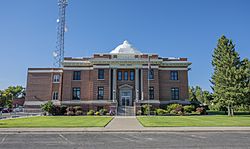
Fremont County Courthouse
|
||
|
||

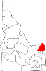
Location within the U.S. state of Idaho
|
||
 Idaho's location within the U.S. |
||
| Country | ||
| State | ||
| Founded | March 4, 1893 | |
| Named for | John C. Frémont | |
| Seat | St. Anthony | |
| Largest city | St. Anthony | |
| Area | ||
| • Total | 1,896 sq mi (4,910 km2) | |
| • Land | 1,864 sq mi (4,830 km2) | |
| • Water | 32 sq mi (80 km2) 1.7% | |
| Population
(2020)
|
||
| • Total | 13,388 |
|
| • Density | 7.1/sq mi (2.7/km2) | |
| Time zone | UTC−7 (Mountain) | |
| • Summer (DST) | UTC−6 (MDT) | |
| Congressional district | 2nd | |
Fremont County is a county in the state of Idaho. In 2020, about 13,388 people lived there. The main city and county seat is St. Anthony.
The county was created in 1893. It was named after a famous explorer, John C. Frémont. Fremont County is also part of the larger Idaho Falls metropolitan area.
Contents
History
Fremont County was formed in 1893. It was made from a part of Bingham County. The county got its name from John C. Frémont.
At first, Fremont County covered a very large area. Over time, other counties were created from its land. These included Jefferson, Madison, Teton, and Clark counties.
The first fur trapping post by a U.S. company was set up here in 1810. Andrew Henry built a fort near Conant Creek. He later moved it to Henry's Fork of the Snake River. The fort was left empty after 1811.
Early settlers started mining, logging, and ranching in the Island Park area before 1870. Yellowstone National Park was created in 1872. This helped Island Park become a popular place for fun.
Farmers began settling in the Egin area around 1879. The towns of Parker and Teton were started in the 1880s. St. Anthony began in 1888, and Marysville (now Ashton) in 1889.
More towns like Warm River, Drummond, and Newdale grew later. The Fremont County Courthouse in St. Anthony is a historic building. It is listed on the National Register of Historic Places.
Geography
Fremont County covers about 1,896 square miles. Most of this area, 1,864 square miles, is land. About 32 square miles is water.
The southern part of the county is in the Snake River Basin. Mountains form the northern border. Montana is to the north, and Wyoming is to the east. A small part of Yellowstone National Park is inside the county.
Adjacent Counties
- Clark County - west
- Jefferson County - southwest
- Madison County - south
- Teton County - south
- Teton County, Wyoming - east
- Gallatin County, Montana - north
- Madison County, Montana - north
- Beaverhead County, Montana - northwest
Fremont County is special because it borders two pairs of counties with the same name. It borders Madison County in Idaho and Madison County in Montana. It also borders Teton County in Idaho and Teton County in Wyoming.
Major highways
National protected areas
- Caribou-Targhee National Forest (part)
- Yellowstone National Park (part)
Demographics
| Historical population | |||
|---|---|---|---|
| Census | Pop. | %± | |
| 1900 | 12,821 | — | |
| 1910 | 24,606 | 91.9% | |
| 1920 | 10,380 | −57.8% | |
| 1930 | 9,924 | −4.4% | |
| 1940 | 10,304 | 3.8% | |
| 1950 | 9,351 | −9.2% | |
| 1960 | 8,679 | −7.2% | |
| 1970 | 8,710 | 0.4% | |
| 1980 | 10,813 | 24.1% | |
| 1990 | 10,937 | 1.1% | |
| 2000 | 11,819 | 8.1% | |
| 2010 | 13,242 | 12.0% | |
| 2020 | 13,388 | 1.1% | |
| 2023 (est.) | 14,196 | 7.2% | |
| U.S. Decennial Census 1790–1960, 1900–1990, 1990–2000, 2010–2020 2020 |
|||
In 2010, there were 13,242 people living in Fremont County. There were 4,436 households. The average household had about 2.88 people. The average family had about 3.32 people.
The median age of people in the county was 33.5 years old. About 38.7% of households had children under 18. Most households (65.9%) were married couples.
Communities
Cities
Unincorporated communities
Education
Fremont County has two main school districts:
- Fremont County Joint School District 215
- Sugar-Salem Joint School District 322
The College of Eastern Idaho serves this county.
Notable people
- Brad Harris, a television and movie actor
- Sherman P. Lloyd, a politician from Utah
See also
 In Spanish: Condado de Fremont (Idaho) para niños
 | James B. Knighten |
 | Azellia White |
 | Willa Brown |


