
Galway, New York facts for kids
Quick facts for kids
Galway
|
|
|---|---|
| Town of Galway | |

Town hall
|
|

Map highlighting Galway's location within Saratoga County.
|
|

Galway
Location in New York
|
|
| Country | United States |
| State | New York |
| County | Saratoga |
| Settled | 1774 |
| Established | 1792 |
| Named for | Galloway, Scotland |
| Area | |
| • Total | 45.00 sq mi (116.56 km2) |
| • Land | 43.82 sq mi (113.50 km2) |
| • Water | 1.18 sq mi (3.06 km2) |
| Population
(2020)
|
|
| • Total | 3,525 |
| • Density | 78.333/sq mi (30.242/km2) |
| Time zone | UTC-5 (EST) |
| • Summer (DST) | UTC-4 (EDT) |
| Area code(s) | 518 |
| FIPS code | 36-091-28112 |
Galway is a town in Saratoga County, New York, United States. In 2020, about 3,525 people lived there. The town also has a small village called Galway. Both the town and the village are in the western part of Saratoga County, just north of Schenectady.
Galway is a quiet, rural area. It has a mix of small businesses, farms, and homes. People live here all year, and some visit for holidays. The town was first called "New Galloway" after a place in Scotland. But when it officially became a town, its name was written down as "Galway" by mistake. Even though it's spelled like Galway, Ireland, it's pronounced differently.
Contents
History of Galway
The first people settled in this area in October 1774. They built their homes in the southern part of what is now Galway town. This was outside the village area.
The town of Galway was officially created in 1792. It was formed from another town called Ballston. At first, it was named "New Galloway." Later, in 1796, the town of Providence was created from the northern part of Galway.
The small community (or hamlet) of Galway became an official village in 1838.
A historic building called the Mead House was added to the National Register of Historic Places in 2004. This means it's an important place to protect because of its history.
Famous People from Galway
Many interesting people have connections to Galway:
- Horace Carpentier was the first mayor and one of the founders of Oakland, California. He was also a successful businessman and gave money to good causes.
- Joseph Henry was an American scientist who lived in Galway for a short time. He made important discoveries about electricity.
- Allen Potter was born in Galway, New York. He became a US congressman and the first mayor of Kalamazoo, Michigan.
- Chauncey Vibbard was from Galway. He helped create the New York Central Railroad. He was also a Congressman and managed railroads for the Union during the American Civil War.
- Mary Evalin Warren (1829–1904) was an author, speaker, and social reformer.
Geography of Galway
Galway covers about 45 square miles (116.6 square kilometers). Most of this area is land, about 44 square miles (114.0 square kilometers). The rest, about 1 square mile (2.6 square kilometers), is water.
The western edge of Galway borders Fulton County.
New York State Route 29 is a main road that runs east to west through the northern part of Galway. It crosses New York State Route 147 at a place called Kimball Corners.
Nearby Areas
The town of Galway is surrounded by other towns:
- To the west: Perth and Broadalbin (in Fulton County)
- To the east: Milton
- To the north: Providence
- To the south: Charlton
Population Information
| Historical population | |||
|---|---|---|---|
| Census | Pop. | %± | |
| 1800 | 2,310 | — | |
| 1810 | 2,705 | 17.1% | |
| 1820 | 2,579 | −4.7% | |
| 1830 | 2,710 | 5.1% | |
| 1840 | 2,412 | −11.0% | |
| 1850 | 2,158 | −10.5% | |
| 1860 | 2,427 | 12.5% | |
| 1870 | 2,174 | −10.4% | |
| 1880 | 1,902 | −12.5% | |
| 1890 | 1,635 | −14.0% | |
| 1900 | 1,350 | −17.4% | |
| 1910 | 1,205 | −10.7% | |
| 1920 | 1,101 | −8.6% | |
| 1930 | 1,137 | 3.3% | |
| 1940 | 1,244 | 9.4% | |
| 1950 | 1,408 | 13.2% | |
| 1960 | 1,746 | 24.0% | |
| 1970 | 2,506 | 43.5% | |
| 1980 | 3,018 | 20.4% | |
| 1990 | 3,266 | 8.2% | |
| 2000 | 3,589 | 9.9% | |
| 2010 | 3,545 | −1.2% | |
| 2020 | 3,525 | −0.6% | |
| U.S. Decennial Census | |||
In 2020, the population of Galway was 3,525 people. The town has grown over the years, as you can see from the census numbers above.
Education in Galway
Galway has its own school district. It includes schools for all ages, from pre-school up to 12th grade.
- The elementary school is called Joseph Henry Elementary.
- The middle school and high school are together known as Galway Junior Senior High School.
- The middle school building was built in 1999.
- A new high school was built in 1952. Before that, Galway had many one-room school houses. Many of these old school houses still exist today.
Communities and Places in Galway
Here are some of the smaller communities and important spots you can find in the town of Galway:
- Birchton: A small community in the southeastern part of town.
- Bunn Corners: A spot near the western border of the town.
- East Galway: A community in the northeastern part of town, located on NY-29. It used to be called "Yorks Corners."
- Fairweather Corners: A community west of Galway village.
- Galway: The main village in the center of the town.
- Galway Lake: A large, privately owned lake. It's about 564 acres (2.28 square kilometers). Only electric-powered or sailboats are allowed here. It's a popular place for summer fun.
- Greens Corners: A community at the northern edge of the town.
- Holsapple Corners: A spot close to Galway village.
- Hooesville: A community on the western border of the town.
- Jeffer's Grove: Located on the eastern side of Galway Lake. It has homes for both year-round and seasonal residents. People here can join an association to use the largest beach on the lake.
- Kimballs Corners: A spot east of North Galway.
- Maywood Grove: A community on the southern and western shores of Galway Lake. It has homes for both seasonal and year-round residents.
- Mosherville: A community in the northeastern part of town, located on NY-29.
- North Galway: A community north of Galway village, located on NY-29.
- O'Brien Corners: A spot near Galway village.
- Parkis Mills: A community northeast of Galway village.
- Ruback's Grove: A private community with camps and summer cottages. It has several beaches, a candy shop, a pavilion, and courts for basketball and volleyball.
- South Galway Corner: A spot near Birchton.
- Shuttleworth Corners: A spot south of Galway village.
- Weissenbaker Grove: A community on the south shore of Galway Lake. It has homes for both seasonal and year-round residents.
- West Galway: A community on the western border of the town.
- Whitesides Corners: A community on the northern edge of the town.
Images for kids
-
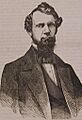
Chauncey Vibbard
-


See also
In Spanish: Galway (Nueva York) para niños
