
Ghaggar-Hakra River facts for kids
Quick facts for kids Ghaggar-Hakra River |
|
|---|---|

Aerial view of Ghaggar river near Chandigarh
|
|

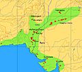
Present-day Gagghar-Hakra river-course, with (pre-)Harappan paleochannel as proposed by Clift et al. (2012).
1 = ancient river |
|
| Country | India, Pakistan |
| Physical characteristics | |
| Main source | Shivalik Hills, Himachal Pradesh, India |
| River mouth | Ottu, Haryana, India 29°17′23″N 74°08′11″E / 29.28972°N 74.13639°E |
| Basin features | |
| Tributaries |
|
| Waterbodies | Kaushalya Dam, Ottu barrage |
The Ghaggar-Hakra River is a special kind of river in India and Pakistan. It's called an intermittent river because it only flows during the monsoon season, which is the rainy part of the year.
The river has two names. It's known as the Ghaggar before it reaches the Ottu barrage (a type of dam). After the barrage, especially as it flows into the Thar Desert, it's called the Hakra.
Long, long ago, before the Indus Valley Civilisation, the Ghaggar was connected to the Sutlej River. It might have also been connected to the Yamuna River. These ancient river paths eventually joined the Nara River, which is now a branch of the Indus River that flows into the sea.
About 8,000 to 10,000 years ago, the Sutlej River changed its path. This left the Ghaggar-Hakra as a river system that only got water from the monsoons. It would then end in the Thar Desert.
The Indus Valley Civilisation grew and became strong when the monsoons became less intense around 5,000 years ago. Many ancient cities from this time (2600-1900 BCE) are found along the middle part of the Hakra in Pakistan. But around 4,000 years ago, the Indus Valley Civilisation started to decline. This happened because the monsoons became even weaker, and the Ghaggar-Hakra river dried up. It became just a small river that flowed only during the rainy season.
Some experts from the 1800s and early 1900s, and even some more recently, have thought that the Ghaggar-Hakra might be the ancient Sarasvati River. This river is mentioned in old Indian texts called the Rig Veda. However, the Ghaggar-Hakra had already dried up by the time those texts were written.
Contents
The River's Journey
The area around the Ghaggar-Hakra river is made of two main parts. One part is called Bangar. These are higher areas that don't get flooded when it rains a lot. The other part is called Khadar. These are lower areas that often get flooded during the rainy season.
The Ghaggar River


The Ghaggar is a river in India that flows only during the monsoon rains. It starts in a village called Dagshai in the Shivalik Hills of Himachal Pradesh. This is about 1,927 meters (6,322 feet) above sea level.
From there, it flows through the states of Punjab and Haryana. Then it goes into Rajasthan. It passes southwest of Sirsa, Haryana and next to Talwara Lake in Rajasthan.
At the Ottu barrage near Sirsa, the Ghaggar is dammed. This dam helps send water into two irrigation canals that reach into Rajasthan.
Rivers Joining the Ghaggar
Several smaller rivers join the Ghaggar. These are called its tributaries. The main ones are the Kaushalya river, Markanda, Sarsuti, Tangri, and Chautang.
The Kaushalya river joins the Ghaggar on its left side. It flows through the Panchkula district in Haryana state. It meets the Ghaggar river near Pinjore, just below the Kaushalya Dam.
The Hakra River
The Hakra is what's left of an old river channel near Fort Abbas City in Pakistan. It's a continuation of the Ghaggar River from India. The Hakra channel is connected to ancient paths of the Sutlej and Yamuna rivers. These paths used to end in the Nara River. The Nara River is a branch of the Indus River that reaches the sea through Sir Creek.
As we learned, the Sutlej River changed its course about 8,000 to 10,000 years ago. This left the Ghaggar-Hakra as a river system that relied on monsoon rains. It would then dry up in the Thar Desert.
This ancient path of the Sutlej and Yamuna flowed through areas of Sindh, like Khairpur and Tharparkar.
Many ancient cities from the Indus Valley Civilisation (2600-1900 BCE) are found along the middle part of the Hakra in Pakistan. No IVC sites have been found further south than the middle of the Bahawalpur district. This suggests that the Hakra river ended there in a series of lakes.
Ancient River Paths
Scientists agree that rivers in the Indus Basin have often changed their paths over time. But figuring out the exact order and dates of these changes can be tricky.
Older studies suggested that the Sutlej and Yamuna rivers flowed into the Hakra until the time of the Mature Harappan period. This would have given the Hakra a lot of water, along with the monsoon rains. These studies thought the Sutlej and Yamuna changed course later, causing the Hakra to dry up in the Thar Desert.
However, newer research shows that the Sutlej and Yamuna rivers changed their paths much earlier. This happened long before the Harappan times. So, the Ghaggar-Hakra was mainly fed by monsoons and dried up during the later Harappan period.
Before the Last Ice Age
The ancient path of the Sutlej River was active until the end of the Ice Age. This was about 10,000 to 8,000 years ago. It used to flow into the Rann of Kutch through the Nara river.
Scientists have studied sand grains from river channels under the dry Ghaggar-Hakra bed. They found that these channels had sand from the Beas River in the west. They also found sand from the Sutlej and Yamuna rivers in the east. This suggests that the Yamuna, or a branch of it, along with a branch of the Sutlej, might have flowed west. This happened between 47,000 BCE and 10,000 BCE. This was long before the Indus Civilisation began.
More recent studies in 2017 confirmed that the Ghaggar-Hakra's ancient path was actually an older course of the Sutlej. The Sutlej moved to its current path before the Harappan Civilisation developed. This change started 15,000 years ago and was complete by 8,000 years ago. This means that the ancient cities were built along a river that flowed with monsoon rains, not a big river fed by melting snow.
Other studies also agree that the major ancient river system in this region stopped flowing long before the Harappan civilisation was established.
The Indus Valley Civilisation

During the Indus Valley Civilisation, the Ghaggar-Hakra river system was not a huge river fed by glaciers from the Himalayas. Instead, it was a river that got its water from the monsoon rains.
The Indus Valley Civilisation grew strong when the monsoons that fed the rivers became less intense around 5,000 years ago. Many important sites from the Mature Indus Valley Civilisation (2600-1900 BCE) are found along the middle part of the Hakra in Pakistan. Around 4,000 years ago, the Indus Valley Civilisation started to decline. This happened because the monsoons became even weaker, and the Ghaggar-Hakra river dried up. It became just a small river that flowed only during the rainy season.
Some archaeologists believe that many sites along the Ghaggar-Hakra might be from local cultures. Some show connections with the Harappan civilisation, but only a few are fully developed Harappan cities. Also, because the Ghaggar-Hakra dried up, many sites remained untouched, which is why so many have been found there.
Why the Hakra Dried Up
Later in the 2nd millennium BCE, the Ghaggar-Hakra river system dried up. It became the small seasonal river it is today. This change greatly affected the Harappan civilisation. Plants from that time show how dry the area became after the river dried up.
The weakening monsoons especially impacted the Ghaggar-Hakra system. The river became very small and often dry, and many people left the area. The Indus Valley Civilisation changed, with people moving to new settlements about 4,000 years ago. During the late Harappan period, fewer sites were found in the middle Ghaggar-Hakra channel and the Indus valley. More sites appeared in the upper Ghaggar-Sutlej channels and in Saurashtra. The people of the IVC moved east towards wetter areas in the Indo-Gangetic Plain.
The same dry conditions around 2500 BCE also caused water shortages in other parts of Asia. This led to changes in plants and made people move around more, becoming nomadic cattle herders. These movements eventually led to the migration of Indo-Aryan people into South Asia.
Most Harappan sites along the Ghaggar-Hakra are now in desert areas. They have remained untouched since the end of the Indus Civilisation. This is different from sites along the Indus and other large rivers, which are often covered by new layers of mud and soil.
Later sites, called Painted Grey Ware sites (around 1000–600 BCE), have been found at former IVC sites along the Ghaggar-Hakra. These sites are sometimes found in the riverbed itself, not just on the banks. This shows that the river was definitely dry by that time. The small number of Painted Grey Ware sites in the Ghaggar valley also suggests the river had already dried up.
The Sarasvati River Connection
Since the 1800s, some people have suggested that the mythical Sarasvati River might be the Ghaggar-Hakra River. The Sarasvati is often mentioned in the Rig Veda, an ancient Indian text. It describes Sarasvati as a powerful river between the Indus and the Ganges. Later texts say it disappeared in the desert. Some thought the Ghaggar-Hakra was once such a mighty river, fed by Himalayan snow. However, newer research shows the Ghaggar-Hakra was monsoon-fed during Harappan times and had already dried up by the time the Vedic texts were written.
In the Rig Veda
The Sarasvati River is mentioned in almost all parts of the Rigveda. It's the only river with whole hymns dedicated to it. It's described as a divine and large river that flows "from the mountains to the samudra" (which some believe means the Indian Ocean). The Rig Veda was written during the later part of the Harappan period. Some experts think the Sarasvati is so important in the Rig Veda because people moved east to Haryana during the late Harappan period (1900–1300 BCE).
The idea that the Ghaggar-Hakra is the Sarasvati River comes from mentions in Vedic texts. For example, in a list of rivers in the Rigveda, the order is Ganga, Yamuna, Sarasvati, Sutudri, Parusni. Later Vedic texts say the river disappeared at a place called Vinasana ("the disappearing"). In even later texts, it's said to join the Yamuna and Ganges as an invisible river at Prayaga (Allahabad). Some believe the holy nature of the modern Ganges is linked to it carrying the sacred waters of the ancient Saraswati River. The Mahabharata also says the Sarasvati River dried up in a desert.
Is it the Sarasvati?
In the 19th and early 20th centuries, scholars like Christian Lassen and Max Müller thought the Ghaggar-Hakra might be the remains of the Sarasvati River. This river is mentioned in the ancient Sanskrit hymns of the Rig Veda, written around 1500 BCE to 1200 BCE.
More recently, some scholars have also identified the old Ghaggar-Hakra River with the Vedic Sarasvati River. They also link the Chautang river to the Drishadvati River. These scholars include Gregory Possehl and Jane McIntosh. Gregory Possehl states that "Linguistic, archaeological, and historical data show that the Sarasvati of the Vedas is the modern Ghaggar or Hakra."
Because most of the Indus Valley sites found so far are actually along the Ghaggar-Hakra river and its branches, not just the Indus river, some Indian archaeologists have suggested a new name. They propose calling it the "Indus Sarasvati Civilization" instead of just the Harappan culture. This is because cultures are often named after where they were first found.
Arguments Against the Idea
Not everyone agrees with this idea. Historian Romila Thapar calls the identification "controversial." She points out that the Rig Veda describes Sarasvati flowing through "high mountains," which doesn't match the Ghaggar's path. She suggests Sarasvati might be the Haraxvati of Afghanistan, also known as the Helmand river. Other experts say the identification is difficult because the Ghaggar-Hakra river was already dry when the Vedas were written.
The idea that the Ghaggar-Hakra was fed by Himalayan snow has also been challenged by recent scientific research. This research shows that the Ghaggar-Hakra system, even though it had more water during Harappan times, was not fed by glaciers and snow from the Himalayas. Instead, it was a system of rivers that flowed all year because of the monsoon rains. Unlike Himalayan rivers that carved out wide valleys as the monsoon decreased, there's no such valley between the Sutlej and the Yamuna. This shows that the Ghaggar-Hakra, or any other river thought to be Sarasvati in that area, did not start in the Himalayas.
Another expert, Rajesh Kocchar, notes that even if the Sutlej and Yamuna had flowed into the Ghaggar during the Vedic period, it still wouldn't match the Rig Vedic descriptions. He says that the snow-fed Sutlej and Yamuna would only make the lower Ghaggar stronger, while the upper Ghaggar would still be small, just like it is today. Rajesh Kocchar believes there are two Sarasvati rivers mentioned in the Rigveda. The older one, which he calls Naditama Sarasvati, flows into a sea. The newer one, called Vinasana Sarasvati, disappears in the sands. The Vinasana Sarasvati is generally accepted to be the Ghaggar-Hakra river. However, the description of the Naditama Sarasvati in the Rigveda matches the Helmand River in Afghanistan. When the Vedic people moved east into Punjab, they named the new rivers they found after the old rivers they knew from Helmand.
Images for kids
-
Outline of the Indus Civilization, with concentration of settlements along the Ghaggar-Hakra.
See also
 In Spanish: Río Ghaggar para niños
