Glascock County, Georgia facts for kids
Quick facts for kids
Glascock County
|
|
|---|---|

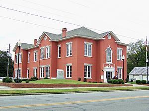
Glascock County Courthouse in Gibson
|
|

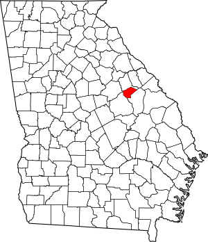
Location within the U.S. state of Georgia
|
|
 Georgia's location within the U.S. |
|
| Country | |
| State | |
| Founded | 1857 |
| Named for | Thomas Glascock |
| Seat | Gibson |
| Largest city | Gibson |
| Area | |
| • Total | 144 sq mi (370 km2) |
| • Land | 144 sq mi (370 km2) |
| • Water | 0.7 sq mi (2 km2) 0.5%% |
| Population
(2020)
|
|
| • Total | 2,884 |
| • Density | 20/sq mi (8/km2) |
| Time zone | UTC−5 (Eastern) |
| • Summer (DST) | UTC−4 (EDT) |
| Congressional district | 12th |
Glascock County is a small county in the state of Georgia, USA. In 2020, about 2,884 people lived there, making it one of the least populated counties in Georgia. The main town, or county seat, is Gibson. Glascock County was officially formed on December 19, 1857.
Contents
History of Glascock County
Glascock County is named after a brave man named Thomas Glascock. He was a soldier who fought in the War of 1812 and was a general in the First Seminole War. He also served as a representative for Georgia in the U.S. government.
Geography of Glascock County
Glascock County covers about 144 square miles. Almost all of this area is land, with only a tiny bit (0.5%) being water. It is the fourth-smallest county in Georgia by land area. Only Clayton, Rockdale County, and Clark County are smaller.
Most of Glascock County is located in the Ogeechee River basin. This means that water from this area flows into the Ogeechee River. A small part of the county, in the northeast, is in the Brier Creek sub-basin, which flows into the Savannah River.
Major Roads in Glascock County
These are the main highways that run through Glascock County:
- State Route 80
- State Route 102
- State Route 123
- State Route 171
Neighboring Counties
Glascock County shares borders with these other counties:
- Warren County - to the north
- Jefferson County - to the southeast
- Hancock County - to the northwest
- Washington County - to the southwest
Communities in Glascock County
Glascock County has several towns and communities where people live.
Cities
- Edge Hill
- Gibson (This is the county seat, meaning it's the main town where the county government is located.)
Town
Unincorporated Communities
These are smaller places that are not officially organized as cities or towns:
- Agricola
- Bastonville
Population of Glascock County
The word "demographics" describes the different groups of people living in an area. Here's how the population of Glascock County has changed over time and what it looked like in 2020.
| Historical population | |||
|---|---|---|---|
| Census | Pop. | %± | |
| 1860 | 2,437 | — | |
| 1870 | 2,736 | 12.3% | |
| 1880 | 3,577 | 30.7% | |
| 1890 | 3,720 | 4.0% | |
| 1900 | 4,516 | 21.4% | |
| 1910 | 4,669 | 3.4% | |
| 1920 | 4,192 | −10.2% | |
| 1930 | 4,388 | 4.7% | |
| 1940 | 4,547 | 3.6% | |
| 1950 | 3,579 | −21.3% | |
| 1960 | 2,672 | −25.3% | |
| 1970 | 2,280 | −14.7% | |
| 1980 | 2,382 | 4.5% | |
| 1990 | 2,357 | −1.0% | |
| 2000 | 2,556 | 8.4% | |
| 2010 | 3,082 | 20.6% | |
| 2020 | 2,884 | −6.4% | |
| 2023 (est.) | 2,954 | −4.2% | |
| U.S. Decennial Census | |||
In 2020, the census counted 2,884 people living in Glascock County. These people lived in 1,108 households, and 726 of those were families.
| Race | Number of People | Percentage |
|---|---|---|
| White | 2,573 | 89.22% |
| Black or African American | 196 | 6.8% |
| Asian | 7 | 0.24% |
| Pacific Islander | 2 | 0.07% |
| Other/Mixed (people of two or more races) | 54 | 1.87% |
| Hispanic or Latino | 52 | 1.8% |
See also
 In Spanish: Condado de Glascock para niños


