Goat Canyon (Tijuana River Valley) facts for kids
Quick facts for kids Goat Canyon |
|
|---|---|
| Cañón de los Laureles | |

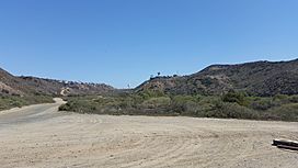
Looking south-southeast within Goat Canyon
|
|
| Area | 4.6 sq mi (12 km2) |
| Geography | |
| Location | Tijuana River Watershed |
| Population centers | Playas de Tijuana Tijuana River Valley, San Diego |
| Borders on | Spooner's Mesa Bunker Hill |
| Traversed by | Mexico–United States barrier Mexican Federal Highway 1D |
Goat Canyon (Spanish: Cañón de los Laureles), also known as Cañón de los Laureles, is a valley that starts in Tijuana, Mexico. It stretches north into the United States, just past the Mexico–U.S. border. The canyon was formed by Goat Canyon Creek. This creek collects water and runoff from areas south of the border. Most of the canyon and its surrounding land are located in Baja California, Mexico.
The canyon was created during the Quaternary period, which is the most recent geological time period. It is surrounded by Bunker Hill to the west and Spooner's Mesa to the east. Part of Goat Canyon has special coastal salt marshland. This area is home to many sensitive and endangered plant and animal species.
People have lived and used the canyon for a very long time, even before Europeans arrived. It was part of a route used by early explorers like the Portolá expedition to reach San Diego Bay. Later, it became part of the Missionary Road, which was no longer used by the late 1800s. Farms once existed in and around Goat Canyon. However, the federal government of the United States later took control of some of this land. In the late 1900s, new buildings and roads were built south of the Tijuana-Ensenada scenic highway. This development caused wastewater to flow northward, a problem that continues today.
Contents
Goat Canyon's Geography
The rocks that make up the walls of Goat Canyon are quite young. They are less than 10,000 years old. These rocks were formed during the Quaternary period. The western wall of the canyon is about 5,000 m (16,000 ft) from the Pacific Ocean. The eastern side of the canyon has a slope that leads up to Spooner's Mesa. This mesa was named after a family who lived there long ago.
Plants and Animals of Goat Canyon
Goat Canyon is home to many special and endangered plant species. These include the southern willow, mule fat, and various maritime succulent scrub plants. Endangered animals also live here, such as the least Bell's vireo, Belding's savannah sparrow, and California gnatcatcher. The northern part of the canyon has a southern coastal salt marsh environment. This unique habitat helps support many of these important species.
History of Goat Canyon
The oldest known sign of human activity in Goat Canyon is a prehistoric campsite. It includes a shell midden, which is a pile of shells left by early people. In the areas around the canyon, archaeologists have found evidence of ancient cultures. These include the San Dieguito and La Jollan prehistoric groups. Inside the canyon, there is even a quarry from the San Dieguito era. In 1769, the Portolá expedition traveled through Goat Canyon. Junípero Serra, a famous Spanish missionary, was with this group on their way to San Diego Bay.
In the 1770s, Spanish explorers wrote about a Native American village. They called it "Milejo" and said it was at the mouth of the canyon. In 1775, members of the Kumeyaay people attacked Mission San Diego de Alcalá. This mission was located in the Tijuana River Valley, which includes Goat Canyon. During this attack, Friar Luis Jayme was killed. He is remembered as the first Catholic martyr in Alta California. When the canyon was part of Alta California, it belonged to Rancho Tía Juana in 1829. By 1833, the canyon was part of Rancho Melijo.
After the Mexican–American War ended in 1848, the land between Imperial Beach and Monument Mesa was owned by E. S. Babcock. He later helped develop Coronado. The land then passed to James Crafton, who owned the Agua Caliente Casino and Hotel. This happened around the time of the Great Depression. Before 1872, the original El Camino Real road ran north from Goat Canyon. In the late 1880s, a railway was completed between San Diego and Tijuana. A city was planned for the area north of the border monument, but it was never built.
In the early 1900s, a homestead with a house and farm was built in the canyon. People lived there until the 1980s, when the city of San Diego declared it unsafe. It operated as a dairy farm and was owned by Harley E. Knox, who was once the mayor of San Diego. The Knox Family owned it until at least 1981. However, the government took control of the land starting in 1970. While the old farm buildings are gone, an excavation found evidence of a prehistoric camp on the same site. This camp shows that local materials were used to make tools. In 2002, it was suggested that this site be added to the National Register of Historic Places. There was also a pig farm in the canyon. In the 1940s, a Mexican family ran it. The father of the family died while building a well at the farm. The remains of the pig farm's home could still be seen in 2001.
Government Activity in the United States
United States military activity near Goat Canyon started with surveying a border marker to the west. Then, activity moved eastward to mark the border set by the Treaty of Guadalupe Hidalgo after the Mexican-American War. A marker, boundary monument #257, was placed on the hill west of Goat Canyon. Starting in 1909, the Bureau of Animal Industry built a fence at the international border. This fence was meant to stop cattle with "Texas Fever" ticks from crossing. Horse patrols also helped guard the fence.
A temporary United States Army outpost was set up during the Mexican Revolution (1910–1920). Later, a more important Navy presence began in the late 1920s. This was when an airfield called Border Field was created. In 1943, 35 buildings were constructed near the canyon on the south side of the base. These buildings, including a trap house, supported military operations at the airfield.
In 1935, a study of existing defenses led to plans for more coastal defenses for San Diego Bay. In 1942, the United States Army built base end stations on the hill west of the canyon. This group of bunkers was called the "Mexican Border Fire Control Station." In 1943, a fire control radar was installed there. These bunkers helped guide the Coastal Artillery batteries at Fort Rosecrans and Fort Emory. In 1951, a plane crashed at the airfield. This led to the airfield no longer being used for aerial gunnery practice. In 1953, the United States Army gave control of the Mexican Border Fire Control Station to the United States Navy. The Navy then put it under the control of the airfield. Border Field airfield itself was controlled by Naval Auxiliary Air Station Imperial Beach.
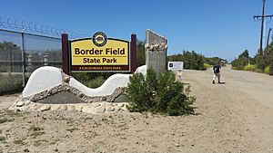
In 1961, Border Field and Goat Canyon were given to the Navy Electronics Laboratory. Other groups using the area included the California National Guard, which had launched pilot-less drones there. The Imperial Beach Police Department also had a shooting range on the land. At that time, there was a new effort to build a city in the area, but these plans never happened. By 1971, the United States Navy gave the site to the State of California. The state then opened Border Field State Park. Sometime between 1981 and 1998, a border road was built on the eastern wall of the canyon. This road, used by the United States Border Patrol, led up to Spooner's Mesa. Its construction unfortunately destroyed an ancient site and old adobe ruins. Since 2009, the bunkers on Bunker Hill are no longer open to the public. This is because the Federal Government took back the land to build the Mexico–United States barrier.
In late April 2018, some people from the Central American migrant caravan were met by American authorities. This happened while they were crossing into the United States in the canyon. They went through a legal process. Around the same time, three people from India were also met by authorities and processed for asylum.
Development and Environmental Impact in Cañón de los Laureles
In 1960, the Tijuana-Ensenada highway was built through the canyon. It runs just south of the Mexico–United States border. The construction of this highway and a concrete channel on the Mexican side led to many people moving into Cañón de los Laureles without proper planning. In 1981, Goat Canyon was not a major source of the 300,000 US gallons (1,100 kilolitres) of wastewater flowing into the Tijuana River. However, by 1983, due to wastewater spills from Goat Canyon, a pump was suggested. Once installed, this pump, which handles flow from Smuggler's Gulch and Goat Canyon, could pump as much as 7,000,000 US gallons (26,000 kilolitres) a day. In 1990, 110,000 US gallons (420 kilolitres) of wastewater flowed from the canyon into the Tijuana River daily. By 1998, low-income homes had been built in the canyon. These homes were often damaged during flash floods caused by seasonal rains.
In 2001, a pipeline was installed to send wastewater from the canyon to the International Boundary Wastewater Treatment Plant. Treated water from this plant is then pumped far offshore, more than 18,000 ft (5,500 m) out. The pipe goes deeper than 100 ft (30 m) below the northern mouth of Goat Canyon.
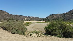
A sediment basin was built at the mouth of the canyon in 2005. This was because a lot of dirt and material from south of the border was flowing into the Tijuana River Estuary. This was causing harm to the natural habitat. The yearly cost to empty this sediment basin is between US$250,000 and over US$1,000,000. By 2009, more than 65,000 people lived in the Mexican part of the canyon. This area includes Colonia San Bernardo. By 2014, the population in the Mexican part of the canyon had grown to 85,000 people. The housing there was described as a "shanty town." Even with the pipeline and upgrades to the wastewater treatment plant, wastewater still flows into Goat Canyon.
In 2010, when the Mexico–United States barrier was built, diversion structures were installed. These help manage the flow of water through the canyon. Also, a 40 yards (37 m) long drainage culvert was placed under the barrier. In 2012, special trash nets were used to catch debris. This prevented it from getting stuck in the sediment. Also in 2012, a $50,000 program was carried out on the Mexican side of the canyon to reduce erosion. By 2014, environmental groups were able to create a recognized watershed council. This gave the area political representation. The goal was to improve the infrastructure within the Mexican part of the canyon.
In March 2017, dark, polluted water flowed from the Mexican side of the canyon into the sediment basins. In the previous month, the water had been red. United States Border Patrol agents reported wastewater from upstream of the canyon in May 2017. This led to health concerns and complaints from politicians like Darrell Issa and Juan Vargas. They were worried about wastewater from Mexico affecting the Tijuana River. In 2017, money for border wastewater projects was removed from the U.S. budget. In October 2017, levels of fecal indicator bacteria were found to be higher than average. In February 2018, more than 50,000 US gallons (190 kilolitres) of waste, including wastewater, flowed through the Goat Canyon pump station. This spilled into the Tijuana River. In May 2018, the Surfrider Foundation released a report about pollution in the Tijuana River, especially in Goat Canyon. It showed that E. coli levels were much higher than standard levels. The water flowing through Goat Canyon has been called some of the worst from Tijuana. In January 2019, the catch basins were described as a "success story of sorts."
 | William M. Jackson |
 | Juan E. Gilbert |
 | Neil deGrasse Tyson |


