Gorakhpur facts for kids
Quick facts for kids
Gorakhpur
Gorakshapuram
|
|
|---|---|
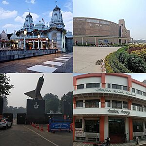
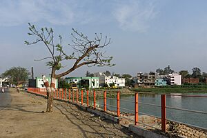
clock wise from top left to left bottom, Gorakhnath Temple, AIIMS Gorakhpur, Gita Press and Indian Air force Base
|
|
| Country | |
| State | |
| District | Gorakhpur |
| Division | Gorakhpur |
| Named for | Gorakhnath |
| Government | |
| • Type | Municipal Corporation |
| • Body | Gorakhpur Municipal Corporation |
| Area | |
| • GMC | 226.0 km2 (87.3 sq mi) |
| • Metro | 1,041.0 km2 (401.9 sq mi) |
| Elevation | 75 m (246 ft) |
| Population
(2011-2020 hybrid)
|
|
| • GMC | 1,300,000 |
| • Density | 5,750/km2 (14,900/sq mi) |
| • Metro | 2,500,000 |
| Demonym(s) | Gorakhpuri, Gorakhpuriya |
| Language | |
| • Official | Hindi |
| • Additional official | Urdu |
| • Regional | Bhojpuri |
| Time zone | UTC+5:30 (IST) |
| PIN |
2730xx
|
| Telephone code | +91-0551 |
| Vehicle registration | UP-53 |
| Sex ratio | ♂1000/903♀ |
| Avg. annual temperature | 26 °C (79 °F) |
| Avg. summer temperature | 40 °C (104 °F) |
| Avg. winter temperature | 18 °C (64 °F) |
Gorakhpur is a city in the Indian state of Uttar Pradesh. It sits along the Rapti River in the eastern part of the state, called the Purvanchal region. It's about 272 kilometers east of Lucknow, the state capital.
Gorakhpur is an important city. It is the main office for the Gorakhpur district, the North Eastern Railway Zone, and the Gorakhpur division. The city is also home to the Gorakhnath Math, which is a famous temple dedicated to the saint Gorakhnath. Since 1963, Gorakhpur has also had an Indian Air Force station.
A very important place here is Gita Press. It's the world's largest publisher of Hindu religious texts. They print books like the Ramayana and Mahabharata. Gita Press has been in Gorakhpur since 1926.
Contents
Understanding the Name of Gorakhpur
The name "Gorakhpur" comes from an old Sanskrit word, Gorakshapuram. This word means "the home of Gorakshanatha". Gorakshanatha was a very famous and respected saint from a group called the Nath Sampradaya.
A Look at Gorakhpur's Past
The first settlements in Gorakhpur were likely a bit north of where the city is today. This is because the Rapti River used to flow differently. It once went through what is now the Ramgarh Tal lake. Farmers digging wells long ago sometimes found parts of old boats. This shows how the river's path has changed over time.
Gorakhpur was a good place for people to settle. It was safe because the Rapti and Rohin rivers protected it on the south and west. In the past, thick forests on the north and east also offered protection.
Early Stories and Rulers
Local stories say that two large water tanks, Mansarowar and Kauladah, were built in the 10th century. These are in an area now called Purana Gorakhpur (Old Gorakhpur). Prince Man Sen is said to have built Mansarowar. His wife, Kaulavati, is credited with building Kauladah.
Later, a group called the Domkatars ruled the area. They built the Domingarh fort where the Rapti and Rohin rivers meet. Even later, the Sarnet rajas of Satasi ruled Gorakhpur. Around the year 1400, a family disagreement led one part of the Satasi family to move. They left their old home by the Ramgarh Tal lake. They moved to a new spot in Purana Gorakhpur, close to the shrine of the famous saint Gorakhnath.
Gorakhpur During the Mughal Empire
By the late 1500s, when Akbar was emperor, Gorakhpur had grown into a large town. The first records of a Mughal army base in Gorakhpur are from 1572. At that time, Payanda Khan governed the city for Munim Khan. Munim Khan was then the governor of Jaunpur.
For a long time, Gorakhpur was the main Muslim army base north of the Ghaghra River. This might explain why there is a strong Muslim presence in the city compared to other parts of the district.
In a book from around 1595 called the Ain-i-Akbari, Gorakhpur is listed as the capital of a sarkar (a type of administrative area). This sarkar was part of the Awadh region. The Gorakhpur sarkar had 24 smaller areas called mahals, and Gorakhpur itself was one of them. The Gorakhpur mahal was expected to provide 200 foot soldiers and 40 cavalry (soldiers on horseback) to the Mughal army. It was also described as having a brick fort on the Rapti River.
Gorakhpur also had a place where coins were made, called a mint, during Akbar's time. They only made copper coins then. By the time Aurangzeb was emperor, the Gorakhpur mint also made silver coins. In the 1600s, Gorakhpur was an important center for trade with the northern mountain regions. This was noted by a traveler named Jean-Baptiste Tavernier.
In the late 1600s, Gorakhpur's official name was changed to Mu'azzamabad. This was done to honor Prince Mu'azzam, who later became Emperor Bahadur Shah I. This new name was used in official papers until the British took over in 1801.
Gorakhpur's Location and Environment
Gorakhpur is about 100 kilometers from the border of Nepal. It is also 193 kilometers from Varanasi, 260 kilometers from Patna, and 270 kilometers from Lucknow.
The city is located on the banks of the Rapti River. This river is a branch of the Ghagra River. A large lake called Ramgarh Tal Lake is also found in the eastern part of the city.
Dealing with Floods
Gorakhpur is one of the areas in Eastern Uttar Pradesh that often experiences floods. Over the last 100 years, floods have become more frequent and stronger. Very big floods happen every three to four years. About 20% of the people are affected by floods. In some areas, floods happen every year. These floods cause a lot of problems for people, including loss of life, health issues, and damage to homes and public buildings.
Gorakhpur's Climate
Gorakhpur has a humid subtropical climate with dry winters. This means it has hot summers and mild winters. It also gets a lot of rain during the monsoon season.
| Climate data for Gorakhpur (1981-2010, extremes 1901-2013) | |||||||||||||
|---|---|---|---|---|---|---|---|---|---|---|---|---|---|
| Month | Jan | Feb | Mar | Apr | May | Jun | Jul | Aug | Sep | Oct | Nov | Dec | Year |
| Record high °C (°F) | 30.0 (86.0) |
35.4 (95.7) |
42.4 (108.3) |
44.4 (111.9) |
49.4 (120.9) |
46.5 (115.7) |
43.2 (109.8) |
39.4 (102.9) |
38.5 (101.3) |
37.4 (99.3) |
36.8 (98.2) |
30.5 (86.9) |
49.4 (120.9) |
| Mean daily maximum °C (°F) | 22.0 (71.6) |
26.4 (79.5) |
32.6 (90.7) |
38.0 (100.4) |
38.3 (100.9) |
36.7 (98.1) |
32.9 (91.2) |
32.9 (91.2) |
32.7 (90.9) |
32.8 (91.0) |
29.9 (85.8) |
25.0 (77.0) |
31.7 (89.1) |
| Mean daily minimum °C (°F) | 8.9 (48.0) |
11.7 (53.1) |
16.1 (61.0) |
21.4 (70.5) |
24.5 (76.1) |
26.1 (79.0) |
25.9 (78.6) |
25.9 (78.6) |
24.9 (76.8) |
20.9 (69.6) |
14.9 (58.8) |
10.4 (50.7) |
19.3 (66.7) |
| Record low °C (°F) | −1.0 (30.2) |
2.8 (37.0) |
8.3 (46.9) |
12.2 (54.0) |
16.6 (61.9) |
16.1 (61.0) |
18.1 (64.6) |
20.2 (68.4) |
17.4 (63.3) |
12.5 (54.5) |
6.7 (44.1) |
2.8 (37.0) |
−1.0 (30.2) |
| Average rainfall mm (inches) | 14.4 (0.57) |
13.9 (0.55) |
7.4 (0.29) |
11.3 (0.44) |
45.2 (1.78) |
185.5 (7.30) |
383.4 (15.09) |
339.5 (13.37) |
228.8 (9.01) |
42.8 (1.69) |
2.2 (0.09) |
8.3 (0.33) |
1,282.7 (50.50) |
| Average rainy days | 1.2 | 1.3 | 0.7 | 0.9 | 3.0 | 7.0 | 13.9 | 12.4 | 9.0 | 2.1 | 0.3 | 0.6 | 52.2 |
| Average relative humidity (%) (at 17:30 IST) | 68 | 55 | 40 | 32 | 42 | 57 | 75 | 77 | 76 | 68 | 66 | 69 | 61 |
| Source: India Meteorological Department | |||||||||||||
Gorakhpur has been recognized as the 4th best "National Clean Air City" in India. This was for cities with populations between 300,000 and 1 million.
People and Languages in Gorakhpur
| Religion in Gorakhpur City (2011) | ||||
|---|---|---|---|---|
| Religion | Percent | |||
| Hinduism | 77.88% | |||
| Islam | 20.61% | |||
| Christianity | 0.74% | |||
| Other or not stated | 0.77% | |||
In 2011, Gorakhpur had a total population of 673,446 people. Out of these, 353,907 were males and 319,539 were females. This means there were about 903 females for every 1000 males. About 69,596 children were aged 0 to 6 years old.
The city's literacy rate (people who can read and write) was 75.2%. For males, it was 79.4%, and for females, it was 70.6%. If we look at people aged 7 and above, the literacy rate was even higher at 83.9%.
In 2011, there were 112,237 households in Gorakhpur. Some reports from 2020 show that 31 more villages have joined the city limits. This has increased the population to over 1 million people. The city's area has also grown from 145.5 square kilometers in 2011 to 226.6 square kilometers.
The most common language spoken in Gorakhpur is Hindi. However, many people who say they speak 'Hindi' actually speak Bhojpuri. Urdu is also spoken by many people in the city.
Getting Around Gorakhpur
Railways: Connecting the City
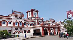
Gorakhpur is well-connected by a large railway network. The main station is Gorakhpur railway station. Until March 2021, it had the longest railway platform in the world, measuring 1366 meters.
In February 2020, the station added 100 flowering pots with special stands on platform No. 2. This was done to add more plants and natural beauty to the station. The Gorakhpur coaching depot used local materials to create these.
Gorakhpur Junction is a Class A-1 railway station. This means it has excellent facilities for passengers. Since October 6, 2013, Gorakhpur has had the world's longest railway platform. This happened after the Gorakhpur Yard was updated, making the platform stretch about 1355.40 meters. Gorakhpur is also the main office for the North Eastern Railways.
Air Travel: Flying In and Out
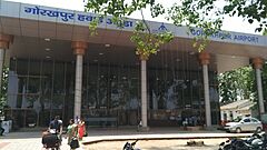
An Indian Air Force station was built in Gorakhpur in 1963. It is called Mahayogi Gorakhnath Airport. This airport was later expanded to allow public flights.
Metro: Future of City Travel
The Gorakhpur Metro is a new project for a light metro system in the city. It will have two lines and 27 stations. This light rail transit (LRT) system is approved to be built in Gorakhpur. It will cover a distance of 27.84 kilometers. On December 1, 2021, the central government approved the detailed plan for the Gorakhpur light metro project.
Learning and Education in Gorakhpur
Gorakhpur is a center for education. It has four universities:
- Deen Dayal Upadhyay Gorakhpur University
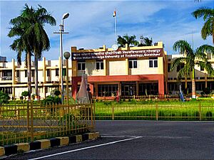
- Madan Mohan Malaviya University of Technology
- Maha Yogi Guru Gorakhnath Ayush University
- Mahayogi Gorakhnath University (a private university)
The city also has two medical colleges: Baba Raghav Das Medical College and AIIMS Gorakhpur. For sports, there is the Veer Bahadur Singh Sports College. The state's first Hotel Management Institute has also opened here. It is known as the State Institute of Hotel Management.
Additionally, Gorakhpur has several private colleges for engineering, pharmacy, and management. These include ITM, KIPM, BIT, GIDA, and SIT Gorakhpur. They are connected with Dr. A.P.J. Abdul Kalam Technical University in Lucknow. There is also a dental institute called Purvanchal Institute Of Dental Science in GIDA, Gorakhpur.
Sports in Gorakhpur
- Veer Bahadur Singh Sports College, Gorakhpur
- Syed Modi Railway Stadium
Famous People from Gorakhpur
Many notable people have connections to Gorakhpur:
- Yogi Adityanath, the current Chief Minister of Uttar Pradesh.
- Leo Amery, a British Cabinet Minister.
- Mahant Avaidyanath, an Indian politician and Hindu guru.
- Premindra Singh Bhagat, who received the Victoria Cross for bravery.
- Amrapali Dubey, an actress.
- Ravi Dubey, an actor.
- Firaq Gorakhpuri, a well-known Indian Urdu writer.
- Narendra Hirwani, an international cricket player.
- Anurag Kashyap, a famous filmmaker.
- Ravi Kishan, a Member of Parliament for the Gorakhpur Lok Sabha constituency.
- Syed Modi, a badminton player and winner of the Arjuna Award.
- Mahendra Nath Mulla, an officer of the Indian Navy who received the Maha Vir Chakra.
- Subrata Roy, an Indian businessman who founded Sahara India Pariwar.
- Jimmy Sheirgill, an actor.
- Saurabh Shukla, an actor.
- Shiv Pratap Shukla, an Indian politician and social worker.
- Vir Bahadur Singh, a former Chief Minister of Uttar Pradesh.
- Paramahansa Yogananda, a yoga guru who founded the Self-Realization Fellowship/Yogoda Satsanga Society of India.
See also
 In Spanish: Gorakhpur para niños
 | William M. Jackson |
 | Juan E. Gilbert |
 | Neil deGrasse Tyson |


