
Green Jacket Shoal facts for kids
Quick facts for kids Green Jacket Shoal |
|
|---|---|

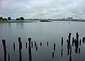
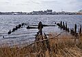
Green Jacket Shoal in 2017, viewed from India Point Park, facing Bold Point Park and the Providence River.
|
|

Green Jacket Shoal
Location in Rhode Island
|
|
| Location | Providence, Rhode Island East Providence, Rhode Island, United States |
| Coordinates | 41°48′53″N 71°23′41″W / 41.81472°N 71.39472°W |
| Type | Shoal |
| Part of | Providence Harbor |
| Primary inflows | Providence River |
| Primary outflows | Seekonk River |
| Surface area | 33 acres (13 ha) |
Green Jacket Shoal is a 33-acre (13 ha) shoal (a shallow area in the water) and a ship graveyard. It is located in the Providence River, between the cities of East Providence and Providence, Rhode Island, in the United States.
This area holds many old things left behind from over a hundred years. You can find parts of abandoned and wrecked ships, broken docks, and other pieces from the area's industrial past. India Point, on the Providence side, was the city's first port, active from 1680 until the early 1900s. Bold Point, on the East Providence side, had businesses that repaired ships.
Later, both India Point and Bold Point became parks. Because of the old debris and more people using the parks for fun, a big cleanup started in 2015. Money for this cleanup came from the government and other groups. Before the cleanup, a study found that Green Jacket Shoal is Rhode Island's largest ship graveyard. It has 29 different ships that have been there for many years. Because of this discovery, experts who study old things in the ocean want to protect the area as a special historical site.
Contents
Where is Green Jacket Shoal?
Green Jacket Shoal is a 33-acre area in the Providence River within Providence Harbor. It is located between the Fox Point area of Providence and the Riverside area of East Providence.
The Seekonk River, which is connected to the Providence River, continues to the northeast. It is bordered by India Point on one side and Bold Point on the other.
A Look Back: History of the Shoal

Green Jacket Shoal has been an important part of the Providence waterfront for a long time. The city's first port was set up at India Point in 1680. India Point was a busy and successful area for trade. It got its name from its trade with places like the East and West Indies.
Important traders like John Brown helped make India Point successful. His family was involved in bringing ships to Providence as part of the Atlantic trade routes. In the late 1800s, large steamships came through the shoal to India Point. These ships brought many immigrants to Rhode Island from places like Ireland, Cape Verde, the Azores, and Portugal.
Bold Point, on the East Providence side, was home to businesses that worked with ships. One important business was the Providence Dry Dock and Marine Railway Co. This company had special ramps and the first floating dry dock in Narragansett Bay. They used these to fix and take care of ships. From 1884 to 1919, this company was the main ship repair place in Providence. Green Jacket Shoal was like its "parking lot" for ships.
The shoal gets its name from the thick, green eelgrass that used to grow there. In 1882, a writer named Moses King said that the thick grass was a problem for the many ships in the area. People were trying to get rid of it.
India Point stayed busy until the early 1900s, but it started to slow down during the Great Depression. A big storm in 1938 also damaged it, and trade mostly stopped. By the 1940s, it had become a place where old scrap was dumped. In the 1960s and 1970s, Providence worked to make the city more beautiful. India Point was turned into a park, which opened in 1974.
The shoal still shows signs of being neglected for a long time. It has a century's worth of old debris. Parts of broken docks, pilings, old ramps, the dry dock, shipwrecks, and abandoned ships stick out of the water. This is because of many years of storms and tough economic times.
As the area changed from an industrial place, more people started using India Point Park and Bold Point Park for fun. The old debris became a problem. It looked bad and was dangerous for anyone using the water. In 2001, the U.S. Army Corps of Engineers suggested filling in the area to make it a salt marsh. Their research found many shellfish like soft-shell clams and oysters in the shallow areas of the shoal.
Years later, when it was found to be a big ship graveyard, experts said it should be protected. They compared it to protecting old buildings on land. In 2018, the Rhode Island Coastal Resources Management Council made the shoal a Marine Protected Area. This means the area is protected, and police can make sure the graveyard is safe.
Green Jacket Shoal: A Ship Graveyard
Before a big cleanup in 2015, a study looked at all the debris in Green Jacket Shoal. In November 2015, a marine archaeologist named David Robinson from the University of Rhode Island counted 26 shipwrecks. This made it the biggest ship graveyard in Rhode Island. In 2018, he found even more, bringing the total to 29 wrecks. He used old records from libraries to help with his research.

.jpeg)
Two of the most famous ships found are old sidewheeler steamboats from the late 1800s and early 1900s. These are the Bay Queen and the Mount Hope. The Bay Queen was 182 feet long and the Mount Hope was 193 feet long. The Bay Queen used to take people on trips around Narragansett Bay to places like Rocky Point Park. After running for 37 years, its engines were removed to turn it into a barge, but it was later left behind. The Mount Hope carried people between Providence, Newport, and Block Island. Some other ships in the shoal are more recent, including a large barge that is the easiest wreck to see.
The shoal was shallow, making it hard for many ships to pass through. But because it was in a busy harbor, it became an easy place to dump unwanted ships. The shoal also had ship repair businesses nearby. This made it simple to take anything valuable from a ship before throwing it away. Robinson believes these reasons are why so many ships ended up in the shoal. When the repair company closed, the ships were left floating near Bold Point. The water was very polluted, which might be why the wrecks are still in good condition today.
According to Robinson, the graveyard has six types of ships: 2 sidewheeler cruise ships, 17 scow barges, 4 sailing ships, 3 harbor steamers, 2 steam/diesel boats, and 1 schooner barge.
Robinson says the graveyard is not just junk. He calls it an "archaeological site of great importance." He sees it as a final look at old sailing ships and how the bay was used for fun by people in Rhode Island. He and another marine archaeologist, Susan Langley, believe the area should be protected for its history and culture.
Cleaning Up the Shoal
.jpg)
Clean Bays, a non-profit group, found a new way to clear debris from under the water. They used a special ship called the Aqualogger, which was changed to have an underwater chainsaw. This chainsaw can cut large pieces of wood into smaller parts. This makes it easier to bring the debris to shore. It also helps avoid stirring up harmful dirt from the bottom of the water. This new method was tested near Bold Point Park in 2014.
In 2015, Clean Bays removed two old barges from the shoal. In 2014 and 2015, they received money from the government to clean up Green Jacket Shoal and 350 acres of the Providence River and Seekonk River. For this bigger project, the group changed their own ships to work like the Aqualogger. Some of the debris that has historical value will be left underwater.
U.S. Senator Sheldon Whitehouse supported the project. He said that this cleanup helps to "reclaim" the Seekonk River and the northern part of the Bay. It makes them better for people to live near and enjoy for fun.
Images for kids
-
Green Jacket Shoal in 2017, viewed from India Point Park, facing Bold Point Park and the Providence River.
-
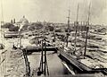
Providence Dry Dock and Marine Company at Bold Point circa 1910
-
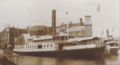
The Bay Queen, a sidewheeler steamboat.
-
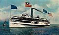
The Mount Hope, another sidewheeler steamboat.
-
Green Jacket Shoal in 2017, viewed from Bold Point Park in East Providence.
