Gulf of Mexico basin facts for kids
The Gulf of Mexico is a large ocean basin located between North America and the Yucatan Block. It formed after the supercontinent Pangaea started breaking apart in the Late Triassic period. This breakup weakened the Earth's crust. The land masses of North and South America continued to pull apart in the Early Jurassic period, about 160 million years ago. The Gulf of Mexico finished forming around 140 million years ago, as the crust thinned and the land sank. The basin is filled with layers of rock and sediment, from the Jurassic period all the way to today (the Holocene). These layers are incredibly thick, reaching between 15 and 20 kilometers deep.
How the Gulf of Mexico Formed
Pangaea: The Supercontinent Breaks Up
Deep below the sediments of the Gulf of Mexico, most of the oldest rocks are thought to be pieces of land that were pushed together when Pangaea formed. But it was when this giant supercontinent began to split apart that the Gulf of Mexico started to take shape.
Before the Gulf of Mexico basin opened up, the breakup of Pangaea caused the Earth's crust to stretch and pull apart in the Late Triassic period. This stretching, especially from the opening of the Atlantic Ocean, created deep cracks in the bedrock called grabens. These grabens filled up with reddish sediments from land and volcanic rocks from a huge eruption. This eruption, called the Central Atlantic Magmatic Plume, poured out a massive amount of basalt (a type of volcanic rock) – about 60,000 cubic kilometers! This lava covered parts of ancient North America, South America, Africa, and Europe. Besides basalt, other important volcanic rocks found are diabases, which are linked to the grabens and red sediments. There are also dike swarms (sheets of rock that cut through older rock) that formed from this volcanic activity.
Early to Mid-Jurassic: The Gulf Takes Shape
The North and South American plates began to separate in the Early to Mid-Jurassic period. This started with the Yucatan Block rotating away from North America. Changes in sea level and heat from the active rift (where the plates were pulling apart) created a shallow sea basin. In this basin, thick layers of Jurassic salts and other evaporated minerals were laid down.
These salt layers sit on top of a thick "transitional crust," which was the local bedrock before the rifting began. As the seafloor spread throughout the Jurassic, more salt continued to be deposited over the newly forming oceanic crust. It was during this time, roughly 140 to 160 million years ago, that the Gulf of Mexico got its familiar shape.
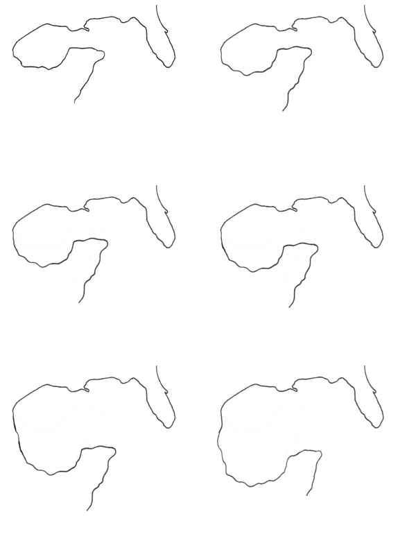
The unique shape of the Gulf of Mexico, surrounded by continental land on all sides, is due to two different types of plate boundaries. One was a transform boundary, where plates slide past each other. The other was a seafloor spreading center, fueled by a hot spot (magmatic plume). These two processes happened at the same time. The transform boundary caused the Yucatan Block to rotate counter-clockwise about 22 degrees, twice. One rotation happened before the seafloor started spreading, and the second happened while the basin was still opening. This created the Gulf of Mexico's current shape and placed the Yucatan Peninsula where it is today.
After the active rifting from the Late Triassic to Mid-Jurassic, which strongly influenced the layers of rock, the Late Jurassic was a much calmer time tectonically. The Gulf of Mexico during the Late Jurassic mostly saw the central area slowly sinking. Also, a lot of sediment built up around the Florida Platform and the northern part of the Gulf of Mexico.
Late Jurassic through the Cretaceous: Later Changes
While a few volcanic rock formations found as far south as Mexico City date back to the Late Jurassic or Early Cretaceous, the Gulf of Mexico itself had very little volcanic activity during that time. It wasn't until the Late Mesozoic Era that some widespread, but small, volcanic eruptions happened along the western and northwestern edges of the Gulf of Mexico. These eruptions left behind an unusual type of volcanic rock field under the Yucatan Peninsula. Scientists believe this volcanism happened along old plate boundaries that were weakened by the weight of sediments in the Gulf.
Layers of Rock and Sediment
Before the Gulf Opened (Pre-rift)
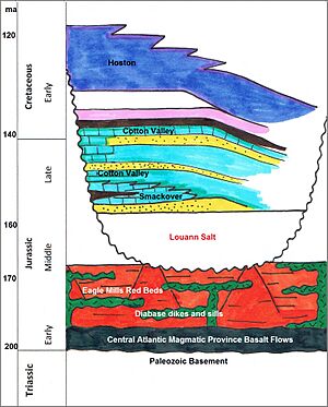
As we mentioned, the very oldest layers of rock in the central Gulf of Mexico basin are now buried under almost 20 kilometers of sediment. These layers formed during the Jurassic period all the way to today. The deepest layers are mostly grabens (cracks in the Earth's crust) filled with "red beds," basalt lava flows, and diabase dikes and sills. These formed and intruded into the crust when Pangaea broke apart and the Central Atlantic Magmatic Plume erupted.
"Red beds" are non-marine layers of rock, often red in color. They have been found in wells drilled in the Gulf of Mexico that reached the Late Triassic and Early Jurassic layers. These red beds fill the graben features. In the Gulf of Mexico basin, these specific red beds are called the Eagle Mills formation. They are found directly beneath the salt, evaporite, and marine sediments deposited during the Jurassic. They are often found with the diabase dikes and basalt flows mentioned earlier.
In the northeastern part of the Gulf of Mexico basin, the bedrock includes pieces of the African Plate. These pieces were left behind when Pangaea broke up and date back to the late Precambrian through the Cambrian periods. It is on top of these ancient plate fragments that the Florida Platform formed, mainly from carbonate and evaporite sediments deposited after the Gulf of Mexico opened.
Early to Mid-Jurassic: Salt and Sea Layers
The salt in the Gulf of Mexico can be divided into two main areas: the Northern Gulf of Mexico salt basin and the Campeche salt basin. Scientists believe they formed at the same time. These are also known as the Louann and Yucatan Salt basins. It's hard to precisely date when the salt was deposited in the Gulf of Mexico. The Louann Salt has no fossils to help date it, so its age is based on the ages of the rock layers above and below it.
Salt deposition began in the Jurassic after the first rotation of the Yucatan Block. This thick salt layer was later split into two main sections as the seafloor spread. Some salt continued to be deposited as the rifting went on. The age of these salts is supported by the layers in the northern Gulf of Mexico. For example, the Eagle Mills red beds below the salt contain dikes as young as 180 million years old. The Smackover formation above the salts contains ammonite fossils, which means the salts are no younger than 156 million years old.
This nearly 4-kilometer-thick salt layer was later deformed. This happened because of uneven and heavy sediment loading on top of it. These sediments included siliciclastic rocks (made of tiny mineral grains), eolian (wind-blown) sediments, and playa (dry lakebed) sediments. These types of sediments are common in dry, land-based environments closer to the shore. This suggests that at certain times during deposition, sediments built up almost to sea level.
The salt structures, which include anticlines (upward folds), pillows, plugs, walls, and large sheets, were created long after the salt was deposited. They formed because of the rapid buildup of sediments on top. Closer to the depocenter (the deepest part of the basin, which for the Gulf of Mexico was towards the spreading center), the land-based sediments gradually change into marine shales (mudstones) and limestones (rock made from shells and marine organisms).
After the salt was deposited, the rock layers show millions of years of marine flooding, carbonate rocks from coral reefs, thick sandstones, and eventually delta sediments (from rivers). All of these helped shape the unique features within the Gulf. The large, shallow marine area called the Florida Platform and underwater marine canyons formed in the 150 million years after the Gulf opened.
After the Gulf Formed (Post-rift)
The sediments deposited after the main rifting period tell a story of several million years. This story includes various carbonate reef formations and major erosion events. These events flooded the Gulf with land-based clastic sediments (broken pieces of older rocks) from inland North America. Essentially, these layers record the tectonic history of the North American continent since the Cretaceous period.
The first post-rift sediments deposited on the Florida Platform were also Mid-Jurassic evaporites. These were followed by deltaic (river delta) and shallow-marine siliciclastics. Eventually, these sediments changed into Cretaceous carbonates, evaporites, and chalks.
More recently, the Laramide Orogeny (a mountain-building event) caused the Rocky Mountains to uplift. This led to more sediments flooding into the Gulf. This rapid loading and burial of the Wilcox Formation (a deepwater Gulf of Mexico formation) is why it is now being used to find oil and gas. This quick loading also caused the first salt flows from beneath the basin-margin region towards the continental slope.
 | Toni Morrison |
 | Barack Obama |
 | Martin Luther King Jr. |
 | Ralph Bunche |


