
Guéret facts for kids
Quick facts for kids
Guéret
|
||
|---|---|---|
|
Prefecture and commune
|
||

The prefecture of the Creuse department
|
||
|
||

Guéret
Location in France

Guéret
Location in Nouvelle-Aquitaine
|
||
| Country | France | |
| Region | Nouvelle-Aquitaine | |
| Department | Creuse | |
| Arrondissement | Guéret | |
| Canton | Guéret-1 Guéret-2 |
|
| Intercommunality | Le Grand-Guéret | |
| Area
1
|
26.21 km2 (10.12 sq mi) | |
| Population
(2014)
|
13,342 | |
| • Density | 509.04/km2 (1,318.41/sq mi) | |
| Demonym(s) | Guérétois | |
| Time zone | UTC+01:00 (CET) | |
| • Summer (DST) | UTC+02:00 (CEST) | |
| INSEE/Postal code |
23096 /23000
|
|
| Elevation | 350–685 m (1,148–2,247 ft) (avg. 518 m or 1,699 ft) |
|
| Website | www.ville-gueret.fr | |
| 1 French Land Register data, which excludes lakes, ponds, glaciers > 1 km2 (0.386 sq mi or 247 acres) and river estuaries. | ||

Guéret (Occitan: Garait) is a town in France. It is the main city, or "prefecture," of the Creuse department. This department is like a county in the Nouvelle-Aquitaine region of France.
Contents
History of Guéret
In 1514, Guéret became the capital of the County of Marche. This was a medieval French county. It covered roughly the same area as the modern Creuse department.
Later, in 1790, new departments were created in France. Guéret was chosen to be the capital of the Creuse department.
Geography of Guéret
Guéret is located on a flat area called a plateau. It sits between two rivers, the Creuse and the Gartempe. The town is at the bottom of two hills: the Puy de Gaudy (651 meters high) and the Maupuy (689 meters high).
The town covers an area of about 26.2 square kilometers. Its average height above sea level is 518 meters. At the town hall, the height is 431 meters.
Guéret is about 291 kilometers from Bordeaux. It is 374 kilometers from Toulouse and 390 kilometers from Paris. Lyon is about 327 kilometers away.
Neighboring Towns
Guéret is surrounded by several other towns. These include Saint-Fiel, Sainte-Feyre, Savennes, and Saint-Christophe. Other nearby towns are La Chapelle-Taillefert, Saint-Léger-le-Guérétois, and Saint-Sulpice-le-Guérétois.
Climate in Guéret
Guéret has an oceanic climate. This means it has relatively warm summers and mild winters. There is also a lot of rain throughout the year. This type of climate is called Cfb in the Köppen climate classification.
Population of Guéret
The people who live in Guéret are called Guérétois (for men) and Guérétoises (for women) in French.
In 2014, Guéret had a population of 13,342 people. This means there were about 509 people living in each square kilometer.
Evolution of the population in Guéret
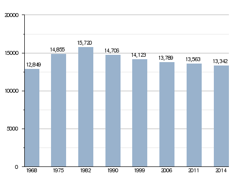
Guéret and the nearby town of Saint-Fiel form an "urban area." In 2013, this area had 14,157 people. This urban area is the center of a larger "metropolitan area." This bigger area includes 32 towns and has a population of 31,499 people.
Guéret's Administration
Guéret is the main city, or "prefecture," of the Creuse department. It is also the capital of the arrondissement of Guéret. An arrondissement is like a district.
Guéret is also the administrative center for two "cantons," which are smaller areas for elections:
- Guéret-1, with 9,332 people (in 2014).
- Guéret-2, with 9,724 people (in 2014).
The town is part of a group of towns called Le Grand Guéret. This group works together on different projects.
Sister Cities
Guéret has a special friendship with another city:
 Stein, Germany (since 1991)
Places to Visit in Guéret
There are several interesting places to see in Guéret:
- The Hotel de Moneyroux: This old building was built in the 1400s. It has a Gothic style. Today, it is the main office for the General Council of the Creuse.
- The Presidial: This building is from the 1600s. It now serves as the town hall for Guéret.
- The Museum of the Sénatorerie: This building was once a home for senators under Napoleon. Since 1832, it has housed a society that studies old objects and nature in Creuse.
- Courtille lake: This is an artificial lake south of Guéret. It's a fun place for recreation with a shaded path around it.
- Chabrières forest: This is a large forest south of Guéret. It has a zoo where you can see wolves. The wolves live in large, walled areas that feel like their natural home. You can also find some big dolmens (ancient stone structures) here.
Gallery
-
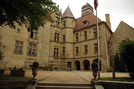
The Hotel de Moneyroux
-
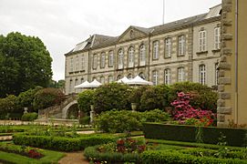
Palais de la Sénatorerie
-
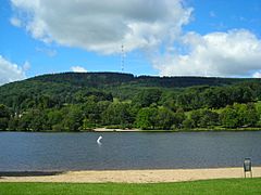
Courtille lake


Related pages
Images for kids
-
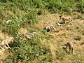
The wolves of Chabrières
-
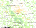
Map of the commune of Guéret


See also
 In Spanish: Guéret para niños
