Halfway Run facts for kids
Quick facts for kids Halfway Run |
|
|---|---|

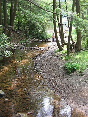
Halfway Run near its mouth
|
|
| Physical characteristics | |
| Main source | valley in Hartley Township, Union County, Pennsylvania between 1,640 and 1,660 feet (500 and 510 m) |
| River mouth | Rapid Run at Halfway Lake in Hartley Township, Union County, Pennsylvania 1,535 ft (468 m) 40°59′29″N 77°11′20″W / 40.9914°N 77.1890°W |
| Length | 1.8 mi (2.9 km) |
| Basin features | |
| Progression | Rapid Run → Buffalo Creek → West Branch Susquehanna River → Susquehanna River → Chesapeake Bay |
| Basin size | 1.51 sq mi (3.9 km2) |
| Tributaries |
|
Halfway Run is a small stream, or 'tributary,' in Union County, Pennsylvania. It flows into another stream called Rapid Run. Halfway Run is about 1.8 miles (2.9 km) long. It runs through Hartley Township. The area of land that drains water into Halfway Run, called its 'watershed,' is about 1.51 square miles (3.9 km2). You can find some interesting 'pingo scars' near the stream. These are wet, sunken areas left by ancient ice formations. The stream is close to the Halfway Run Natural Area and R.B. Winter State Park, which are great places to explore nature. Many different kinds of trees grow along its banks.
Contents
Journey of Halfway Run
Halfway Run starts in a valley in Hartley Township. This is near the border with Lewis Township. The stream generally flows towards the west-southwest. It runs alongside Bake Oven Mountain for almost its entire path.
Along its way, Halfway Run gets water from an unnamed stream. This smaller stream flows from a spring called Boiling Spring. Eventually, Halfway Run turns southwest. It then flows into Halfway Lake. Right after the lake, it meets and joins Rapid Run.
Water Quality
Halfway Run is known for its clear water. It is not listed as a 'polluted' or 'impaired' waterbody. This means the water quality is good.
Land and Geology Around the Stream
The land around Halfway Run is quite interesting. The stream's mouth, where it joins Rapid Run, is about 1,535 feet (468 m) above sea level. Where the stream begins, its source, the elevation is higher. It is between 1,640 and 1,660 feet (500 and 506 m) above sea level. The stream itself is about 10 feet (3 m) wide.
Long ago, about a million years ago, Halfway Run was part of a different river system. It used to flow into Elk Creek. But over time, Halfway Run and Rapid Run changed their paths. They moved from the Penns Creek drainage basin to the West Branch Susquehanna River drainage basin.
You can find unique 'pingo scars' near Halfway Run. These are special areas that were once formed by ice pushing up the ground. Before these were found here, the only known pingo scars in the United States were in Illinois. Some of the larger pingo scars along Halfway Run are very deep. The muck inside them can be up to 15 feet (5 m) deep. This muck contains parts of plants, like wood, that are 12,800 years old. Near the start of the stream, these scars seem to join together.
Halfway Run's Watershed
The watershed of Halfway Run covers about 1.51 square miles (3.9 km2). A watershed is all the land where water drains into a particular stream or river. The entire stream is located within the Hartleton quadrangle. This is a specific map area used by the United States Geological Survey.
Halfway Run is located near the Halfway Run Natural Area. This is a special place set aside for nature. Also, R.B. Winter State Park is close to the stream. Both areas offer opportunities to enjoy the outdoors and see wildlife.
Wildlife and Plants
Halfway Run is a great place for fish. Wild trout naturally reproduce in the stream. You can find them from where the stream starts all the way to its mouth.
The forests along Halfway Run are mature. They have tall white pines and hemlocks. Further away from the stream, you can see other trees. These include red oak, white oak, yellow birch, sugar maple, and American beech. Mountain laurel plants also grow in the area.
Some of the drier pingo scars have hemlock seedlings and larch trees. You can also find Sphagnum moss and low blueberry bushes. There are also some wet, grassy patches.
Historically, beavers built dams in the Halfway Run watershed. One beaver dam still holds water today.
The Halfway Run Site is important for nature. It is listed on the Union County Natural Areas Inventory. A federally endangered bulrush plant lives there. The site is also a breeding ground for amphibians. Many vernal pools are found at this site. Vernal pools are temporary pools of water that form in spring. They are important for amphibians to lay their eggs.
 | Selma Burke |
 | Pauline Powell Burns |
 | Frederick J. Brown |
 | Robert Blackburn |

