Hammersley Fork facts for kids
Quick facts for kids Hammersley Fork |
|
|---|---|

Hammersley Fork
|
|
| Other name(s) | Hammersley Fork Creek |
| Physical characteristics | |
| Main source | central Eulalia Township, Potter County, Pennsylvania between 1,800 and 1,820 feet (549 and 555 m) |
| River mouth | Kettle Creek in Leidy Township, Clinton County, Pennsylvania 968 ft (295 m) 41°26′50″N 77°52′11″W / 41.4471°N 77.8698°W |
| Length | 10.0 mi (16.1 km) |
| Basin features | |
| Progression | Kettle Creek → West Branch Susquehanna River → Susquehanna River → Chesapeake Bay |
| Basin size | 32.55 sq mi (84.3 km2) |
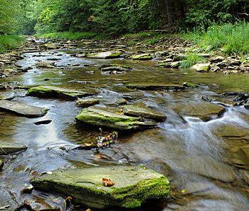
Hammersley Fork (also called Hammersley Fork Creek) is a stream in Potter County and Clinton County, Pennsylvania. It flows into Kettle Creek. The stream is about 10.0 miles (16.1 km) long. It flows through Wharton Township and Leidy Township. The land area that drains into the stream, called its watershed, is about 32.7 square miles (85 km2). The main type of rock in the area is the Pottsville Formation. Many bridges cross this stream.
There are no major state roads in the Hammersley Fork watershed. There are also very few township roads. However, you can find dirt and gravel roads. Several places allow you to cross the stream. The first people settled here in 1827. Roads were built a few years later. In the early 1900s, people cut down a lot of trees for wood. This is called logging. Today, there is almost no logging here. Wild trout live and reproduce naturally in the stream. Most of the stream has a wide area of trees and plants along its banks. This is called a riparian buffer.
Contents
The Stream's Journey
Hammersley Fork starts in the middle of Eulalia Township, Potter County. This is close to the Sinnemahoning Creek area. The stream flows southeast towards Elk Lick Knob. Here, it gets water from a smaller stream called Black Mark Hollow.
Then, the stream turns south and flows into a valley. It passes by Bunnell Ridge. The valley gets deeper as it goes. Hammersley Fork receives water from several small streams. After Elkhorn Run joins it, the stream turns southwest. In the southern part of the township, another stream called Bell Branch flows into it. Hammersley Fork then turns south-southeast and leaves Eulalia Township.
After leaving Potter County, Hammersley Fork enters Leidy Township, Clinton County. It keeps flowing south, going past Susquehannock State Forest. The stream continues south for a while. It then crosses Pennsylvania Route 144. Right after crossing this road, Hammersley Fork meets Kettle Creek. It joins Kettle Creek about 19.90 miles (32.03 km) before Kettle Creek ends.
Water Conditions
The water in Hammersley Fork has a certain amount of alkalinity. This means how well it can balance acids. The alkalinity ranges from 0.011 to 0.015 ounces per cubic foot (11 to 15 mg/l). The stream bed has coarse sand and fine gravel.
Hammersley Fork can get quite warm. In July 2003, the water temperature was between 68 to 72 °F (20 to 22 °C) in one section. In another part, it was between 70 to 73 °F (21 to 23 °C).
The stream carries a small amount of sediment each year. It also carries small amounts of nitrogen and phosphorus. These are nutrients that can affect water quality.
Land and Rocks Around the Stream
The land near where Hammersley Fork meets Kettle Creek is about 968 feet (295 m) above sea level. Where the stream begins, its source, the elevation is higher. It is between 1,800 and 1,820 feet (549 and 555 m) above sea level.
The main type of rock in the Hammersley Fork area is the Pottsville Formation. The highest point in the stream's watershed is 2,365 feet (721 m) above sea level. This means there's a big difference in height, about 1,374 feet (419 m), from the highest to the lowest points. At its mouth, the stream is about 54 feet (16.5 m) wide.
You can find many gravel bars in the lower parts of the stream. These are piles of rocks and gravel. The stream keeps its width because new material that builds up is often washed away. There is also a "headcut" in the lower stream. This is a small waterfall-like drop where the stream splits into three parts for about 69 feet (21 m). One spot near the mouth of Hammersley Fork is the only place in the Kettle Creek area that has been changed by humans to make the stream straighter. This is called stream channelization.
Hammersley Fork flows over solid bedrock or large cobble stones for much of its length. From the point where Nelson Branch joins it, the stream mostly flows in the middle of its valley. There's a spot near Nelson Branch where the land has erosion. It is 26 feet (8 m) high and 59 feet (18 m) long. There is a flat area called a floodplain at the mouth of Hammersley Fork. Two bridges cross the stream near its mouth. One carries Pennsylvania Route 144 and the other carries Hammersley Avenue.
The Hammersley Fork Watershed
The watershed of Hammersley Fork covers about 32.7 square miles (85 km2). This makes it the second-largest area that drains into Kettle Creek. There are 57.42 miles (92.41 km) of streams within this watershed. The mouth of the stream is in an area called Tamarack on maps. Its source is in an area called Short Run. The stream also flows through an area called Hammersley Fork.
Some camps and homes are located on the left bank of Hammersley Fork. They are about 0.2 miles (0.32 km) upstream from the mouth. There are many dirt roads and gravel roads around the edges of the stream's upper watershed. However, there are no major state roads. Also, there are almost no local township roads in the watershed. Much of the upper part of the watershed can only be reached by walking. There are five places where roads cross the stream or its smaller branches. You can also find some agricultural land along the stream.
History and Fun Activities
Hammersley Fork was officially added to a list of geographic names on August 2, 1979. It is named after a person called J. P. Hammersley.
In 1827, two men, Jacob "Old Jake" Hammersley and Archie Stewart, settled at the mouth of Hammersley Fork. They were the first settlers to come so far up the Kettle Creek area. They also built a gristmill on the west bank of the stream. By 1833, there were no roads in the area. Later in the 1800s, Nathan Tuttle ran a type of sawmill on the stream. A small town, also called Hammersley Fork, grew up by 1852. In 1902, John Gartsee started another village named Hammersley in the middle part of the stream. This village was meant to supply logging camps nearby. By 1902 to 1910, there was a network of railroad tracks in the watershed.
Logging was a very big business in the Hammersley Fork area in the early 1900s. But since then, there has been almost no industrial activity. You can still find an old railroad grade along Hammersley Fork. People have been putting fish into the stream, which is called fish stocking, since the 1930s or 1940s.
A bridge that carries road T545 over Hammersley Fork was built in 1933. It was repaired in 2010 and is 64.0 feet (19.5 m) long. Another bridge was built over the stream in 1962 and fixed in 2011. This bridge is 107.0 feet (32.6 m) long and carries Pennsylvania Route 144.
The Cherry Springs Civilian Conservation Corps camp was built near the start of Hammersley Fork in 1933. The Hammersley Trail is part of the Susquehannock Trail System. This trail passes by the mouth of Hammersley Fork.
Amazing Wildlife
Wild trout naturally reproduce in Hammersley Fork. They live from the very beginning of the stream all the way to its mouth. Large birds called Great blue herons have been seen near the stream's source. This is interesting because they usually live in bigger river valleys. Small insects called little yellow stoneflies also live here. Brown trout first appeared in the stream in the 1920s. They were stocked in a nearby stream called Cross Fork. By the 1940s, the number of brown trout in Hammersley Fork grew a lot.
The Forrest H. Duttlinger Natural Area is located along Hammersley Fork. Most of the stream flows through this special natural area. It is a large area of 1521 acres. It includes 158 acres of very old old-growth hemlock trees. The Hammersley Wild Area is also in the watershed. The stream's watershed is recognized as an important area for different kinds of plants and animals. The Pennsylvania Department of Environmental Protection also says this area is very valuable.
The amount of tree cover over the stream, called the canopy, changes along Hammersley Fork. Near the mouth, the canopy cover is between 0 and 50 percent. However, most of the stream has a good amount of trees and plants along its banks, forming a strong riparian buffer.
In one section of Hammersley Fork, the average tree canopy cover is 62 percent. The lower part of this section has even more cover, at 86 percent. In another part of the stream, the upper section has 93 percent canopy cover. The middle part has 58 percent, and the lowest part has 89 percent. Where Nelson Branch meets Hammersley Fork, the tree cover is 70 percent. For about 2 miles (3.2 km) downstream from this meeting point, the canopy cover averages 40 percent. Trees you might see in this area include hemlock, red maple, river birch, sycamore, and willow.
 | Bessie Coleman |
 | Spann Watson |
 | Jill E. Brown |
 | Sherman W. White |


