
Kettle Creek (Pennsylvania) facts for kids
Quick facts for kids Kettle Creek |
|
|---|---|

Kettle Creek at Ole Bull State Park
|
|
| Physical characteristics | |
| Main source | Elk Township, Tioga County Pennsylvania |
| River mouth | West Branch Susquehanna River at Noyes Township, Clinton County, Pennsylvania 41°18′03″N 77°50′18″W / 41.3009°N 77.8382°W |
| Length | 43 mi (69 km) |
| Basin features | |
| Basin size | 244 sq mi (630 km2) |
Kettle Creek is a tributary (a smaller stream that flows into a larger one) of the West Branch Susquehanna River in Pennsylvania. It flows through Tioga, Potter, and Clinton counties. The creek is about 43 miles (69 km) long.
Many parts of Kettle Creek are known as "Class A Wild Trout streams", which means they are excellent places for trout. However, some lower parts of the creek have pollution from old mines, called acid mine drainage. The upper parts of the creek are very clean and healthy.
Kettle Creek flows through several townships and counties, eventually reaching the community of Westport. Important smaller streams that join Kettle Creek include Cross Fork, Hammersley Fork, and Little Kettle Creek. The Kettle Creek Lake is also located on the creek. Some parts of the creek have high levels of substances like iron, aluminum, manganese, and sulfates. The water temperature can also get quite warm.
Kettle Creek is a freestone stream, which means its water flows over rocks like sandstone. Most of the land around the creek (about 93%) is covered by forests, and a large part (about 92%) is public land, like state forests. Not many people live permanently in the area, but many come for seasonal camps.
The first people to live near Kettle Creek were the Iroquois and Delaware Native Americans. European settlers began arriving in 1794. Later, industries like coal mining and lumbering became important, but they have mostly stopped.
Contents
Where Kettle Creek Flows
Kettle Creek starts in a valley in Elk Township, Tioga County. It flows southeast for a short distance before turning west.
Journey Through Potter County
After leaving Elk Township, Kettle Creek enters Abbott Township, Potter County. It flows southwest, passing by ridges and hollows, and picking up several small streams. Then it enters Stewardson Township. Here, it flows west-southwest, passing the community of Oleona, where Little Kettle Creek joins it. The creek also starts flowing next to Pennsylvania Route 144.
Kettle Creek then makes a sharp turn to the south-southwest before returning to a southwestern direction. It flows through Ole Bull State Park, passing Keeney Mountain and more hollows. Briefly, it turns west-northwest to meet the Cross Fork tributary in Stewardson Township. Finally, it turns southwest again and leaves the township.
Journey Through Clinton County
When Kettle Creek leaves Stewardson Township, it enters Leidy Township in Clinton County. Soon after, it passes a gauging station (a place where water levels are measured). It continues flowing southwest, passing Dykes Peak and Turtle Point. The Hammersley Fork tributary joins the creek as it flows through Susquehannock State Forest.
A few miles after Hammersley Fork, Kettle Creek makes two big bends, called meanders, and turns south. It flows through Sproul State Forest and then Kettle Creek State Park. In the state park, the creek flows into a lake and passes the Alvin R. Bush Dam, which is about 8.5 miles (13.7 km) upstream from where the creek ends.
At the southern edge of Leidy Township, Kettle Creek makes more bends, crossing the border with Noyes Township multiple times. It then meanders for several miles through Noyes Township, passing old strip mine areas and another gauging station. The creek finally ends at the community of Westport, near Pennsylvania Route 120.
Important Smaller Streams
Some of the main streams that flow into Kettle Creek include Germania Branch, Little Kettle Creek, Cross Fork, Hammersley Fork, Trout Run, Beaverdam Run, and Twomile Run.
In the upper parts of Kettle Creek, streams like Billings Branch, Sliders Branch, Germania Branch, and Long Run join from the north. In the middle parts, Little Kettle Creek, Cross Fork, and Hammersley Fork also join from the north. Further downstream, Trout Run, Walters Run, and Beaverdam Run join from the northwest, while Hevner Run and Spicewood Run join from the east. Near the end of Kettle Creek, Twomile Run joins from the northeast.
Water Quality and Flow
Water Chemistry
Scientists measure different substances in Kettle Creek. For example, at a measuring station downstream of the Alvin R. Bush Dam, the amount of iron in the creek is about 265.3 pounds (120.3 kg) per day. The amount of manganese at the mouth of the creek is about 130.0 pounds (59.0 kg) per day.
The amount of aluminum at the measuring station is about 247.6 pounds (112.3 kg) per day. The level of acidity (how acidic the water is) at the creek's mouth is about 3,063.9 pounds (1,389.8 kg) per day.
At the measuring station, the water has small amounts of iron (0.15 milligrams per liter), manganese (0.04 milligrams per liter), and aluminum (0.14 milligrams per liter). The acidity is 0.64 milligrams per liter, and the alkalinity (how well the water can neutralize acid) is 11.36 milligrams per liter.
In 2006, the amount of sulfates in Kettle Creek was measured. Upstream of polluted areas, the sulfate levels were low (under 10 to 17 parts per million). In areas affected by acid mine drainage, the sulfate levels were much higher (37 to 1375 parts per million).
The amount of chloride in Kettle Creek is very low. Some parts of Little Kettle Creek and Kettle Creek have high nitrate levels. The phosphorus levels are generally low. Scientists found that substances like chromium, nickel, copper, zinc, arsenic, cadmium, and lead are so low they are almost undetectable. The water in Kettle Creek is relatively "soft," meaning it doesn't have many minerals. The amount of dissolved oxygen (oxygen in the water for fish) ranges from 6.5 to 18.2 parts per million.
Water Flow and Temperature
The amount of water flowing in Kettle Creek at Westport has varied greatly, from 4 to 6280 cubic feet per second between 1970 and 2006. The average flow was 396 cubic feet per second. The pH (a measure of acidity or alkalinity) of the creek at this point was around 6.4 in the early 1980s. The pH of the entire watershed ranges from 5.5 to 8.6.
The alkalinity of the creek has decreased over time. In the 1950s and 1960s, it was 20 to 25 milligrams per liter, but by 1993, it was 11 to 15 milligrams per liter.
On the western side of the lower Kettle Creek watershed, there are 26 sources of acid mine drainage from old underground mines. This polluted water flows into Kettle Creek and other streams. These sources release about 479 gallons of acidic water per minute, containing high levels of acidity, iron, aluminum, manganese, and sulfates.
Kettle Creek has been known to have unusually warm water since 1942. On hot, sunny days, the temperature can be close to 80 °F (27 °C). The lower 12 miles (19 km) of Kettle Creek are affected by acid mine drainage. Most of the pollution comes from many small sources rather than one big one.
Dams on Kettle Creek
There are four dams on Kettle Creek. Three of them are in state parks and are used for recreation: the Ole Bull Dam, the Kettle Creek Dam, and Kettle Creek Lake. These dams are between 12 feet (3.7 m) and 15 feet (4.6 m) high. The Alvin R. Bush Dam, which helps control flooding, is much taller at 165 feet (50 m).
Land and Rocks Around the Creek
The lower parts of the Kettle Creek watershed are in the Appalachian Plateau region. The highest point in the Kettle Creek watershed is 2,512 feet (766 m) above sea level.
Kettle Creek is a freestone stream, meaning it has little limestone and low alkalinity. The soils in the lower part of the watershed are very acidic, deep, and drain well. The rocks in this area are mostly sandstone (78%) and other sedimentary rocks (22%).
Important rock layers in the watershed include the Huntley Mountain Formation, the Burgoon Sandstone, the Pottsville Group, and the Allegheny Group. These rocks formed during different ancient time periods, like the Devonian, Mississippian, and Pennsylvanian epochs. The Allegheny Group is the only rock formation in the watershed that contains coal worth mining.
The Kittanning Coals are found in the higher parts of the lower Kettle Creek watershed. The Upper Kittanning coal is usually 3 feet (0.91 m) thick. The Lower Kittanning Coal is found deeper, about 80 feet (24 m) to 150 feet (46 m) below the Upper Kittanning Coal.
The Clearfield-McIntyre Syncline (a downward fold in rock layers) runs through the western lower part of the watershed. North of this is the Wellsboro Anticline (an upward fold), and south is the Hyner Dome. Cracks in the rocks cause some streams to have straight valleys and Kettle Creek itself to make sharp turns.
The main channel of Kettle Creek was measured to be 100 feet (30 m) wide in 1942, but by 2000, it had grown to 154 feet (47 m) wide. The water level at the Alvin R. Bush Dam is usually around 841 feet (256 m) above sea level.
The steepest part of the Kettle Creek watershed is near Alvin Bush Lake, with an average slope of 19.12 degrees. The flattest part is the Twomile Run area, with an average slope of 8.32 degrees.
There are several places along Kettle Creek where the banks are eroding. For example, a quarter-mile upstream of where Germania Branch joins the creek, there's an area of erosion that is 3.5 metres (11 ft) high for a 16 metres (52 ft) stretch.
Kettle Creek's Watershed

The watershed of Kettle Creek covers an area of 244 square miles (630 km2). It is located in Clinton, Potter, Cameron, and Tioga Counties. Most of the lower Kettle Creek watershed (93.5%) is forested land. About 2.7% is old coal mines and quarries, 2.4% is grassland, and 1.4% is developed land. This area is not very crowded. The upper parts of the watershed are also mostly forests, with some meadows along the river and camps.
Public lands, like state forests and state parks, make up 92% of the watershed. Most private land is located near floodplains. Only a small amount (0.3%) of the watershed is used for farming. Wetlands make up less than 1% of the watershed's area.
There are 429 miles (690 km) of streams in the watershed. The Alvin R. Bush Dam is considered the dividing point between the lower and upper parts of the Kettle Creek watershed.
The largest of the 17 main smaller watersheds within Kettle Creek are Cross Fork (49.92 square miles), middle Kettle Creek (45.29 square miles), and Hammersley Fork (32.55 square miles). The smallest are Spicewood Run (3.11 square miles) and Billings Branch (3.01 square miles).
There are no large towns in the Kettle Creek watershed, but there are several small communities like Westport, Cross Fork, and Oleona. Many seasonal camps are also found here.
Pennsylvania Route 44 and Pennsylvania Route 144 pass through the Kettle Creek watershed. There are 294 miles (473 km) of roads in the watershed. Most of these roads are not paved. The Cross Fork area has the most road crossings over streams.
Fewer than 20% of the people living in the watershed are permanent residents. Most seasonal visitors come from areas like Lancaster or Philadelphia.
History of the Area

Before Europeans arrived, the Iroquois and Delaware Native Americans lived near Kettle Creek. European explorers first came in the mid-1700s, and the first settlers arrived in 1794. Many early settlers were farmers. A group of German settlers created a community called Germania in the northern part of the watershed. Later, in the early 1900s, Slovaks also moved into the area.
The Kettle Creek Path was an old Native American trail that connected the Cowanesque River to the West Branch Susquehanna River through Kettle Creek. Native Americans likely camped here for hunting and fishing. An Indian village at the mouth of the creek was destroyed in 1763. In 1784, a treaty bought much of this land from the Native Americans for $7000, though they kept hunting rights until 1804.
Richard Gilmore was the first European to claim land on Kettle Creek in 1794. Other early settlers followed, and the population slowly grew. Simeon Pfoutz built a sawmill and gristmill on the creek in 1813.
Early roads were built to help travel and trade. The first post office in the watershed opened at Westport in 1847, and the first bridge over the creek was built there in 1852.
In 1852, the Norwegian violinist Ole Bull tried to start a colony in the Kettle Creek watershed, but it was not successful. The first schoolhouse was built in 1858.
Several mills powered by Kettle Creek were built by 1852. The lumbering industry became very important in the mid-1800s, especially after railroads arrived in the late 1800s. Companies like Lackawanna Lumber Company cut down many trees. However, the lumber industry collapsed after 1910, and many people left the area.
Coal mining began in the Kettle Creek watershed in 1874. The Kettle Creek Coal Company created the community of Bitumen and operated six underground mines until 1929. Strip mining (removing coal from the surface) was also done from the 1930s to 1977.
Natural gas was found in the watershed in 1902, and drilling continued until 1958.
In 1966, a pollution incident caused a large amount of waste to enter Kettle Creek, killing over 185,000 fish.
The Alvin R. Bush Dam was built in the late 1950s to help prevent flooding. The Kettle Creek Watershed Association was founded in the late 1990s to protect the creek. Today, the main industries in the Kettle Creek watershed are tourism, agriculture, and lumbering.
There are two petroleum pipelines exposed on Kettle Creek. The Kettle Creek Watershed Association is concerned that if they broke, the creek could be severely harmed.
Why the Name "Kettle Creek"?
Some people think Kettle Creek was named after the kettles used by Native Americans on the West Branch Susquehanna River.
Animals and Plants of Kettle Creek
Kettle Creek is known for its excellent trout fishing. There are 67 miles (108 km) of streams in the watershed that are classified as "Class-A" trout streams. In the 1880s, large brook trout were common, but due to too much fishing, they became rare after 1920. The Kettle Creek watershed has 8% of all the Class A Wild Trout Streams in Pennsylvania.
Brown trout were brought to the watershed in the late 1800s, and Rainbow trout began to be stocked in the creek in the 1930s and 1940s. A total of 35 types of fish live in the watershed, with 21 being native species and 14 introduced.
A herd of elk was introduced to the watershed around 2000. Black bears, Coyotes, gray squirrels, beavers, minks, bobcats, raccoons, and red and gray foxes also live here. Before European settlement, wolves and elk lived in the watershed.
Bald eagles, ospreys, kingfishers, Canada geese, herons, and mallard ducks have been seen around Kettle Creek and Kettle Creek Lake. Other birds of prey, ring-necked pheasants, and ruffed grouse also live in the watershed.
Scientists study tiny creatures called macroinvertebrates (like insects) in the water to check its health. In clean parts of Twomile Run, many different types of macroinvertebrates were found. But in parts affected by acid mine drainage, only a few types were found.
The Hilsenhoff Biotic Index is a way to measure water quality using macroinvertebrates. For Kettle Creek, this index ranges from 2.54 to 4.61, with lower numbers meaning cleaner water.
The trees along the creek, called the canopy coverage, vary. Some areas have only 20% coverage, while others have 90%. The riparian zone (the area along the riverbanks) mostly has hemlock, cherry, river birch, and eastern hop hornbeam trees. In many places, the natural tree buffers along the stream are missing or too thin.
The watershed has a high diversity of mammals and birds. Fish diversity is highest in the Twomile Run area.
About half of the trees in the Kettle Creek watershed are northern hardwood trees. Other common trees include oak trees (29%) and red maple (4%).
Fun Activities at Kettle Creek
The main activities people enjoy in the Kettle Creek watershed are hunting, fishing, and hiking. Many hunting and fishing camps are visited by people from all over Pennsylvania and other states. The upper parts of Kettle Creek are famous for trout fishing. Even former United States president Ulysses S. Grant once visited the area!
The Pennsylvania Department of Conservation and Natural Resources has built a large ATV trail in the Huling Branch area, which is the biggest public ATV trail in Pennsylvania.
Some parts of the upper Kettle Creek can only be reached by walking.
Ole Bull State Park is located in the Kettle Creek watershed and opened in 1925. The Susquehannock State Forest is near the creek's beginning. Kettle Creek State Park, near the Alvin R. Bush Dam, is popular with fishermen. Much of the lower watershed is in Sproul State Forest. Tioga State Forest and Elk State Forest also cover small parts of the watershed.
Images for kids
-
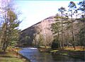
Kettle Creek at Ole Bull State Park
-
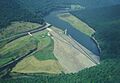
The Alvin R. Bush Dam, which separates the lower Kettle Creek watershed from the rest of the watershed
-
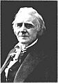
Ole Bull, who tried to start a colony in the Kettle Creek watershed
