
Happisburgh facts for kids
Quick facts for kids Happisburgh |
|
|---|---|
 Happisburgh village sign |
|

Happisburgh
|
|
| Area | 9.63 km2 (3.72 sq mi) |
| Population | 889 ONS and Norfolk CC 2011 census |
| • Density | 92/km2 (240/sq mi) |
| OS grid reference | TG 39 31 |
| • London | 137 miles (220 km) |
| Civil parish |
|
| District | |
| Shire county | |
| Region | |
| Country | England |
| Sovereign state | United Kingdom |
| Post town | NORWICH |
| Postcode district | NR12 |
| Dialling code | 01692 |
| Police | Norfolk |
| Fire | Norfolk |
| Ambulance | East of England |
| EU Parliament | East of England |
| UK Parliament |
|
Happisburgh (pronounced Haz-bur-uh) is a small village in the English county of Norfolk. It sits right on the coast, east of the B1159 road. This village is known for its interesting history and its ongoing battle with the sea. The closest larger town is North Walsham, about 6 miles (10 km) to the west.
The name 'Happisburgh' first appeared in the Domesday Book in 1086. It means 'Hæp's fort' or 'fortified place'.
Happisburgh became very important for archaeology in 2010. Scientists found flint tools here that were almost 800,000 years old. This is the oldest proof of humans living anywhere in the UK! In 2013, even older human footprints were found on the beach. These discoveries show that early humans were active in this area a very long time ago.
Land in Happisburgh has been disappearing into the sea for thousands of years. The village area has shrunk because of erosion, which is when the sea wears away the land. This erosion has been happening at the same speed for about 5,000 years. In 1968, special walls called groynes were built to try and slow down the erosion.
Contents
How Happisburgh is Governed
Happisburgh is part of an electoral ward, which is an area used for local elections. This ward includes Happisburgh and several nearby villages like Lessingham and East Ruston. People in these areas vote for representatives who help manage local services and decisions.
Cool Places to See in Happisburgh
St Mary's Church
The tall stone church of St Mary's was first built by the Normans in 1086. It was then rebuilt in the 15th century. The church's tall tower is a very important landmark for sailors. It warns them about dangerous sandbanks nearby.
In 2001, a new staircase was added to the tower. It was made in memory of a local schoolboy, Thomas Marshall, who sadly died nearby. You can still see a piece of shrapnel from a German bomb in the church's pillars. This bomb was dropped during World War II in 1940. The church also has an old, octagonal font from the 15th century. It is carved with figures of lions and satyrs.
Happisburgh Lighthouse
The red-and-white striped lighthouse is about 0.5 miles (800 m) south of the church. It is special because it's the only lighthouse in Great Britain that is run independently. It is also the oldest working lighthouse in East Anglia, built in 1790. You can sometimes visit it on Sundays during the summer.
Happisburgh Lifeboat Station
The first lifeboat station was built in 1866 by the Royal National Lifeboat Institution (RNLI). It was placed on the cliffs because of the dangerous Haisborough Sands nearby. This station closed in 1926.
A new, smaller boathouse was built in 1965 for an inshore lifeboat. In 1987, a more modern building replaced it, offering better facilities for the lifeboat crews. This building was made even bigger in 1998.
In 2002, the ramp used to launch the lifeboat was washed away by erosion. A temporary station was set up quickly. The original station is now used for training and selling souvenirs. The station has received an RNLI Silver Medal for its long and valuable service.
Happisburgh Manor
Happisburgh Manor is a large, beautiful estate with a private garden. It was built around 1900-1902 as a summer home for a wealthy landowner. The main house was partly destroyed by a bomb during the war but was later restored. It is now a Grade II* listed building, meaning it is very important historically.
Coastal Erosion in Happisburgh

Happisburgh has been losing land to the sea for thousands of years. For example, a 12-acre plot of land disappeared in just one night in 1845. Today, houses that were once far from the sea are now right on the edge of cliffs. They are expected to fall into the sea eventually.
Sea defenses were built in 1959 to try and slow down this erosion. However, government rules have changed, and central government no longer funds coastal protection here. Beach Road, which leads to the sea, is constantly being eroded. Some houses closest to the sea were taken down in 2012 as part of a plan to manage the coast.
Happisburgh has also tried new ways to deal with climate change and sea level rise. This includes a government-funded plan to help people move their homes further inland. In 2023, there were plans to move a car park, built with reusable materials, away from the eroding cliff.
Amazing Archaeology Discoveries
.png)
In 2010, scientists found flint tools near Happisburgh. These tools were dated to be between 814,000 and 970,000 years old. This makes them the oldest evidence of humans in the UK. These tools were likely left by early hunter-gatherers, possibly a human species called Homo antecessor. They lived on the flood plains and marshlands near an ancient river Thames. The tools were then washed downriver to Happisburgh.
In May 2013, even more exciting news came out. The Happisburgh footprints were discovered on the beach. These are the oldest human footprints found outside of Africa, being more than 800,000 years old!
Local Folklore
There is an old story from the 16th century that Happisburgh is haunted. People say the ghost of a smuggler still roams the area.
Famous People from Happisburgh
- Charles William Peach, a naturalist and geologist
- Richard Porson, a famous classical scholar
Images for kids
-
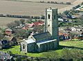
Saint Mary's, Happisburgh
-

The lighthouse at Happisburgh
-
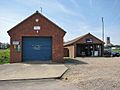
Happisburgh's lifeboat station and Royal National Lifeboat Institution shop
-
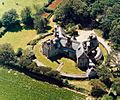
Happisburgh Manor (c.1992)
-
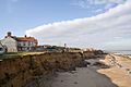
The precarious position of houses due to the effects of coastal erosion
-
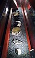
Stone tools discovered at Happisburgh
.jpg)


