
Hathras facts for kids
Quick facts for kids
Hathras
|
|
|---|---|
|
City
|
|

Banke Bhawan, residence of poet Kaka Hathrasi
|
|
| Nickname(s):
Asafoetida City
|
|

Hathras
Location in Uttar Pradesh

Hathras
Location in India
|
|
| Country | |
| State | Uttar Pradesh |
| Division | Aligarh |
| District | Hathras |
| Government | |
| • Type | Municipal Council |
| • Body | Hathras Municipal Council |
| Area | |
| • Total | 142 km2 (55 sq mi) |
| Elevation | 178 m (584 ft) |
| Population
(2011)
|
|
| • Total | 160,909 |
| Languages | |
| • Official | Hindi, Urdu |
| Time zone | UTC+5:30 (IST) |
| PIN |
204101
|
| Telephone code | 05722 |
| Vehicle registration | UP-86 |
| Sex ratio | 870 ♂/♀ |
Hathras is an important city in Uttar Pradesh, India. It is the main city of the Hathras district. This district was created on May 3, 1997, by joining parts of Aligarh, Mathura, and Agra districts. Hathras is also part of the Aligarh Division.

People in Hathras mainly speak Braj Bhasha, which is a type of Hindi. It's similar to Khariboli, another language spoken near Delhi. Hathras is also famous for making asafoetida, a spice used in cooking.
Contents
How Hathras is Governed
Hathras is the main city for its district. The district has four smaller areas called subdivisions: Hathras, Sasni, Sikandra Rao, and Sadabad.
Hathras is also a special area for elections, known as a Lok Sabha constituency. It is reserved for people from Schedule Caste groups. The district has three areas for state elections, called assembly constituencies. The Hathras district was once known as Mahamaya Nagar. It was formed in 1997 from parts of the Aligarh, Mathura, and Agra districts.
Local Government Bodies
The Hathras (Assembly constituency) area has nine local government bodies. These help manage the different towns and villages:
- Hathras
- Sikandra Rao
- Sasni
- Sadabad
- Mursan
- Hasayan
- Sahpau
- Mendu
- Purdil Nagar
Geography and Location
Hathras is located at 27°36′N 78°03′E / 27.6°N 78.05°E. It is about 185 meters (606 feet) above sea level. The city is located where major highways from Agra, Aligarh, Mathura, and Bareilly meet. Hathras is known for its big changes in temperature throughout the year.
In 2001, Hathras had a population of 123,243 people. About 53% were male and 47% were female. The city's literacy rate (people who can read and write) was 60%. This was higher than India's national average of 59.5% at that time. About 66% of males and 53% of females could read and write. Around 14% of the population was under six years old.
Nearby Cities and Distances
Here are some cities close to Hathras and how far away they are:
| City | Distance from Hathras town | Direction from Hathras town |
|---|---|---|
| Aligarh | 36 km | Towards the north |
| Mathura | 41 km | Towards the west |
| Khair | 46 km | Towards the northwest |
| Agra | 53.8 km | Towards the south |
Climate and Weather
Hathras has a humid subtropical climate. This means it has hot, humid summers and mild, dry winters, similar to other parts of north-central India.
Summer usually starts in April and lasts until May. The monsoon (rainy) season begins in late June and continues until early October. This season brings a lot of humidity.
| Climate data for Hathras | |||||||||||||
|---|---|---|---|---|---|---|---|---|---|---|---|---|---|
| Month | Jan | Feb | Mar | Apr | May | Jun | Jul | Aug | Sep | Oct | Nov | Dec | Year |
| Mean daily maximum °F (°C) | 71.6 (22.0) |
82.0 (27.8) |
92.1 (33.4) |
102.2 (39.0) |
108.7 (42.6) |
104.0 (40.0) |
95.0 (35.0) |
93.2 (34.0) |
96.6 (35.9) |
94.1 (34.5) |
73.4 (23.0) |
76.1 (24.5) |
114.1 (45.6) |
| Mean daily minimum °F (°C) | 42.1 (5.6) |
53.6 (12.0) |
62.8 (17.1) |
72.3 (22.4) |
82.0 (27.8) |
85.1 (29.5) |
81.0 (27.2) |
78.8 (26.0) |
70.7 (21.5) |
73.4 (23.0) |
50.2 (10.1) |
44.6 (7.0) |
45.5 (7.5) |
| Source: India Meteorological Department | |||||||||||||
Transportation in Hathras
Hathras is well-connected by trains. It has four railway stations:
- Hathras Junction railway station
- Hathras Road railway station
- Hathras City railway station
- Hathras Kila railway station
A new station called New Hathras was built on the special Freight Corridor Line, which is used for cargo trains. Hathras is the only city in its area that has five railway stations named after it.
History of Hathras
In the late 1700s, the town of Hathras was controlled by a Jat leader. His fort was located on the east side of the town. The British took over Hathras in 1803 and attacked the fort in 1817.
Under British rule, Hathras quickly became an important trading center. For a while, it was the second most important trading city in the Doab region, after Cawnpore (now Kanpur).
Hathras officially became a district on May 6, 1997. This happened when some areas (called Tehsils) from Aligarh and Mathura districts were joined together. Hathras is part of the Braj region in Northern India. It is known for its industries, literature, and cultural activities. It has been an industrial hub since the time of the British Raj.
Famous People from Hathras
- Kaka Hathrasi (a well-known poet)
- Raja Mahendra Pratap (a king from Mursan Riyasat)
- Thakur Malkhan Singh (a freedom fighter)
- Ramveer Upadhyay (a former government minister in Uttar Pradesh)
Images for kids
-
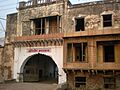
Banke Bhawan, residence of poet Kaka Hathrasi
-
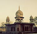
A Masjid in Hathras
See also
 In Spanish: Hathras para niños
