
Bareilly facts for kids
Quick facts for kids
Bareilly
Bareli
|
|
|---|---|
|
City
|
|
       Top to bottom; Left to right:
Civil Lines skyline, Lakshminarayan Temple, Dargah Tajush Shariah, a dharamshala near Bareilly Junction, Bareilly ka Jhumka, Memorial at IVRI Izzatnagar and Bareilly College |
|
| Nicknames:
Nath Nagri
|
|

Bareilly
Location in Uttar Pradesh

Bareilly
Location in India
|
|
| Country | |
| State | |
| District | Bareilly |
| Founded | 1537 |
| Founded by | Jagat Singh Katehriya |
| Government | |
| • Type | Municipal Corporation |
| • Body | Bareilly Municipal Corporation |
| Area | |
| • City | 106 km2 (41 sq mi) |
| • Metro | 123 km2 (47 sq mi) |
| Elevation | 268 m (879 ft) |
| Population
(2011)
|
|
| • City | 903,668 |
| • Density | 8,530/km2 (22,080/sq mi) |
| • Metro | 985,752 |
| • Sex ratio | 895 ♀/1,000 ♂ |
| Demonym(s) | Bareillian |
| Language | |
| • Official | Hindi |
| • Additional official | Urdu |
| Time zone | IST |
| PIN codes |
2430xx
|
| Vehicle registration | UP-25 |
Bareilly is a big city in the Uttar Pradesh state of India. It's one of the largest cities in Western Uttar Pradesh. Bareilly is also the main city for the Bareilly division and the historic area called Rohilkhand. The city is located in the flat Indo-Gangetic Plains. It's about 252 kilometers (157 miles) northwest of Lucknow, the state capital. It's also 265 kilometers (165 miles) east of New Delhi, the national capital.
In 2011, Bareilly had a population of over 900,000 people. This makes it the eighth most populated city in Uttar Pradesh. It's also the 17th largest in northern India and the 54th largest in all of India. The city sits on the Ramganga River. There's a special dam called the Ramganga Barrage built here to help with watering farms.
The first settlement in this area was started in 1537. A local leader named Jagat Singh Katehriya founded it. He called it 'Bans-Bareli' after his two sons. The city came under the rule of the Mughal Empire in 1569. By 1596, it was the capital of a local area. The modern city of Bareilly was officially started by Mughal governor Mukrand Rai in 1657. In 1658, it became the main city for the Budaun region.
As the Mughal Empire became weaker, the Kingdom of Rohilkhand grew stronger. Bareilly was a very important city in this kingdom. The city later came under the control of the Oudh State in 1774. This happened after the Rohillas (people from Rohilkhand) were defeated in a war. The Nawab of Oudh then gave Bareilly to the British East India Company in 1801. A military base was set up south of the city in 1811. A fort was built there in 1816. During the Indian Rebellion of 1857, rebels took control of Bareilly. It stayed independent under Khan Bahadur Khan Rohilla until the British took it back in 1858.
Bareilly is famous as the birthplace of the Barelvi Movement. This is a Sunni Islamic group started by the scholar Imam Ahmed Raza Khan. His tomb at the Bareilly Sharif Dargah is visited by many people every year.
The city is also known as Nath Nagri because it has many old Shiva temples. More recently, it's been called Jumka City. Bareilly is a center for making furniture. It also trades in cotton, grains, and sugar. Bareilly is one of the 100 Smart Cities being developed in India. It's also one of the nine "counter magnet cities" for the National Capital Region (NCR). The city has the Bareilly Airport with flights to major Indian cities. The Bareilly Junction railway station is one of the busiest in India.
Contents
- Exploring Bareilly's Rich History
- Bareilly's Location and Weather
- People and Culture in Bareilly
- Bareilly's Economy and Industries
- Getting Around Bareilly: Transport and Travel
- Learning and Education in Bareilly
- Bareilly's Defense and Military Presence
- Fun Places to Visit in Bareilly
- Famous People from Bareilly
- See also
Exploring Bareilly's Rich History
Bareilly has a very long and interesting history. It has been an important place for thousands of years.
Ancient Times: Legends and Early Settlements

According to the famous Indian epic, the Mahābhārata, the Bareilly region was called Panchala. It is believed to be the birthplace of Draupadi. She was also known as 'Panchali' because she was from Panchāla. The story says that Gautama Buddha once visited the old fort city of Ahichchhatra in Bareilly. Also, the Jain holy leader Parshva is said to have achieved spiritual enlightenment at Ahichchhatra.
Archaeologists have found many old things in Bareilly. The remains of Ahichchhatra, the capital of Northern Panchala, were found near Ramnagar village. During excavations in the 1940s, painted grey pottery was found. This pottery is linked to the arrival of the Aryans in the Ganges–Yamuna Valley. Thousands of ancient coins have also been found at Ahichchhatra. Many amazing terracotta (clay art) pieces from Ahichchhatra are considered masterpieces of Indian art. These findings help us understand the history of the region from about 2000 BC to 1100 AD.
Bareilly's Founding and Mughal Rule

In the 12th century, different groups of Kshatriya Rajputs ruled the area. Then, for 325 years, the region was part of the Delhi Sultanate, ruled by Muslim Turkic leaders. After that, it became part of the growing Mughal Empire.
The modern city of Bareilly was founded in 1537 by Jagat Singh Katehriya. He named it after his two sons. The Mughal governor Mukrand Rai officially started the modern city in 1657. In 1658, Bareilly became the main city for the Budaun province. The Mughals encouraged Afghans to settle in Bareilly. This helped them control the local Rajputs who sometimes rebelled. After the Mughal Empire weakened, many Afghans moved away.
British Influence and the 1857 Rebellion

In 1774, the British East India Company and the Nawab of Awadh defeated the Rohillas. Bareilly then came under the Nawab of Awadh's rule. In 1801, the Nawab gave Rohilkhand, including Bareilly, to the Honourable East India Company.
Bareilly was a major center during the Indian Rebellion of 1857. This rebellion started when Indian soldiers, called sepoys, rebelled against the British. It spread across many parts of northern India. In Bareilly, Khan Bahadur Khan Rohilla, a grandson of Hafiz Rahmat Khan, took control and formed his own government in 1857. He even made his own silver coins. However, the British took Bareilly back in 1858 when the rebellion ended.
Bareilly's Path to Independence
Bareilly Central Jail held many people who supported India's fight for freedom. One famous person was Yashpal, who even got married while in prison in 1936. This was the first time such a ceremony happened in an Indian jail. After this, the rules were changed to prevent future prison marriages.
Bareilly's Location and Weather
Bareilly is located in northern India. It's surrounded by different areas: Pilibhit and Shahjahanpur to the east, Rampur to the west, Udham Singh Nagar (in Uttarakhand) to the north, and Badaun to the south.
Geography and Rivers

The city's land is mostly flat and has good water sources. It slopes gently towards the south. The soil is very fertile, and there are many groups of trees. To the north, there's a rainforest area called the tarai. You might find tigers, bears, deer, and wild pigs there. The Sarda River forms the eastern border and is a main waterway. The Ramganga River collects most of the water from the Kumaon mountains. Other rivers like the Deoha and Gomati are also nearby.
Bareilly is about 252 meters (827 feet) above sea level. It's located near the left bank of the Ramganga River. Smaller rivers like Deoranian, Nakatiya, and Shankha flow through the city. The older part of Bareilly is about 10 kilometers (6 miles) from the Ramganga. Over time, the city has grown, especially towards the south and north. Industrial areas like C.B. Ganj and Izzatnagar have also become part of the city. Bareilly's urban area is 106 square kilometers (41 square miles). Including its metropolitan area, it covers 123 square kilometers (47 square miles).
Bareilly's Climate: Summers and Winters
Bareilly has a humid subtropical climate. This means it has hot summers and cool winters. The average temperature for the whole year is about 25°C (77°F). June is usually the hottest month, with an average of 32.8°C (91°F). January is the coolest, with an average of 15°C (59°F).
Bareilly gets about 1039 millimeters (41 inches) of rain each year. July is the wettest month, with about 307 millimeters (12 inches) of rain. November is the driest, with only about 5 millimeters (0.2 inches). It rains on about 38 days a year. Most of the rain falls in the summer, but it can rain throughout the year.
Bareilly was ranked the 17th best "National Clean Air City" in India in 2024. This was for cities with populations between 300,000 and 1 million.
City Layout and Green Spaces

Bareilly's streets follow a traditional pattern. Most roads lead to different cities. The city center is where Nainital Road and Bada Bazaar–Shyam Ganj Road meet, at a place called Kutubkhana. This area can get very busy, so cars are not allowed during the day.
Bareilly is on the Ganges plain, which has very fertile soil. However, the lower parts of the plain can sometimes flood. The city is on the Ramganga River, and seven other rivers flow through the district. The lower Himalaya mountains are about 40 kilometers (25 miles) north of the river.
People and Culture in Bareilly
Bareilly is a diverse city with a growing population.
Population and Demographics
| Historical Population of Bareilly | ||
|---|---|---|
| Year | Pop. | ±% |
| 1847 | 92,208 | — |
| 1853 | 101,507 | +10.1% |
| 1865 | 105,649 | +4.1% |
| 1872 | 102,982 | −2.5% |
| 1881 | 113,417 | +10.1% |
| 1891 | 121,039 | +6.7% |
| 1901 | 133,167 | +10.0% |
| 1911 | 129,462 | −2.8% |
| 1921 | 129,459 | −0.0% |
| 1931 | 144,031 | +11.3% |
| 1941 | 192,688 | +33.8% |
| 1951 | 208,083 | +8.0% |
| 1961 | 272,828 | +31.1% |
| 1971 | 326,106 | +19.5% |
| 1981 | 449,425 | +37.8% |
| 1991 | 590,661 | +31.4% |
| 2001 | 720,315 | +22.0% |
| 2011 | 903,668 | +25.5% |
| Source: 1847-1865 - Bareilly district Gazetteer 1911 1872-1891 – Imperial Gazetteer of India 1901-2011 - District Census Handbook Bareilly |
||
In 2011, Bareilly had a population of 903,668 people. There were more males (476,927) than females (426,741). For every 1000 males, there were 895 females. About 107,323 people were children aged 0 to 6 years.
More than half of the people in Bareilly can read and write. About 60.1% of the population is literate. This means 66.5% of males and 55.7% of females are literate. For people aged 7 and older, the literacy rate is even higher, at 68.3%.
Religions and Beliefs
| Religions in Bareilly (2011) | ||||
|---|---|---|---|---|
| Religion | Followers | |||
| Hinduism | 58.58% | |||
| Islam | 38.80% | |||
| Sikhism | 0.90% | |||
| Christianity | 0.78% | |||
| Other or not stated | 0.93% | |||
Most people in Bareilly are Hindus, making up 58.58% of the population in 2011. Islam is the second most common religion, followed by about 38.80% of the people. Other religions like Sikhism (0.90%), Christianity (0.78%), Jainism (0.05%), and Buddhism (0.05%) are also practiced. A small number of people follow other religions or did not state their religion.
Bareilly is famous for the Barelvi Movement, a Sunni Islamic group. This movement has millions of followers in South Asia. The city is also known as Nath Nagri because it has seven ancient Hindu temples dedicated to Shiva. These temples are Dhopeshwar Nath, Madhi Nath, Alakha Nath, Tapeshwar Nath, Bankhandi Nath, Pashupati Nath, and Trivati Nath. There is also a Roman Catholic Diocese of Bareilly.
-
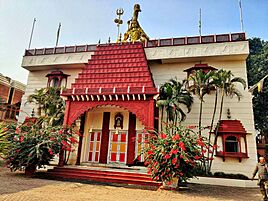
The Trivatinath Temple is one of seven Nath Temples dedicated to Lord Shiva.
-
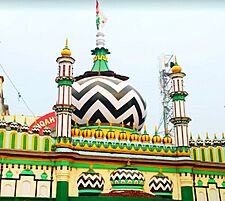
Bareilly Sharif Dargah is the tomb of Ahmed Raza Khan.
-
A Sikh Gurudwara in Model Town, Bareilly.
-
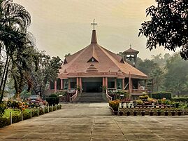
Cathedral of St. Alphonsus, a main church in Bareilly.


Languages Spoken
The main official languages in Bareilly are Hindi and Urdu.
Local Culture and Festivals

Bareilly hosts several important fairs and festivals. The Chaubari fair is held every year by the Ramganga River. It takes place during Kartik Purnima. A big part of this fair is the horse market, where people come from far away to buy and sell horses.
The Nariyawal fair lasts about 15 days. It is the second largest fair in the city. This fair happens during Gupt Navratri at the Goddess Sheetla temple in Nariyawal. It's mostly a religious event, attracting many visitors. The three-day Uttarayani fair is also held annually at the Bareilly Club ground. This fair takes place from January 13 to 15 for Makar Sankranti. Many cultural events are performed in Kumaoni and Garhwali languages. Artists from the nearby hill regions come to perform.
Bareilly's Economy and Industries
Bareilly's economy has grown a lot since India opened up its markets.
Key Industries and Trade

Trade in Bareilly has become more varied, with many new shopping malls. However, the economy in the surrounding rural areas still relies on farming. Bareilly is also known for its handicrafts, especially zari-zardosi embroidery work on cloth. It's also famous for bamboo and cane furniture.
In the early 1800s, Bareilly was a busy center for cotton. In 1802, there were about 20,000 looms (weaving machines) in the city. They produced goods worth a lot of money each year. Other popular trades in the 1820s included making glass, jewelry, glass and lac bangles, and gold and silver thread. People also did wire drawing, made charpoy (beds), ran grocery shops, and sold kebabs.
Growth and Challenges in Industry

The city's trade and business grew quickly after railway lines were built in the early 1900s. Many factories were set up, like the National Brewery Company, a match factory, and a flour mill. The Indian Wood Products Limited started in Izzatnagar in 1919, making a lot of Catechu. Other industries like Indian Turpentine & Rosin (1926) and Western Indian Match Company (WIMCO; 1937) were built in C.B. Ganj. A sugar factory, HR Sugar Factory, was established in Nekpur in 1932. By the 1940s, Bareilly became a major industrial and business area. Many banks and schools were also opened.
Industrial growth continued after India became independent in 1947. Small businesses making khandsari (a type of sugar), furniture, and oil started in Shahamatganj and Nai Basti. Industrial areas were created in CB Ganj (1958), Bhojipura (1979), and Parsakhera (1980). By the 1960s and 1980s, many markets were built around residential areas.
However, by the late 1990s, many industries in the city closed down. The Indian Turpentine & Rosin Factory closed in 1998. The sugar mill in Nekpur stopped production in 1998, even though it had won an award for high production in 1997. A rubber factory in Fatehganj West also closed in 1999. Its products were famous across Asia, and it employed about two thousand people. The WIMCO factory in CB Ganj, which supplied matches nationwide, closed in 2015.
.jpg)
Today, the Indian Farmers Fertiliser Cooperative (IFFCO) has a large plant in Aonla, about 30 kilometers (19 miles) away. This plant makes ammonia and urea. Bareilly has very fertile land, good for growing sugarcane, rice, pulses, and wheat. The Indian government also started a program to blend ethanol into fuel in Bareilly. The city also has CNG and LPG fuel stations. Bareilly district was the first to use India's bio-fuel standard.
Getting Around Bareilly: Transport and Travel
Bareilly has a good network of roads, railways, and even an airport.
Road Connections

Bareilly is located on National Highway 30. This highway connects Sitarganj in Uttarakhand to Vijaywada in Andhra Pradesh. This long highway passes through Bareilly, Lucknow, Allahabad, Jabalpur, and Raipur. Other national highways that start in Bareilly include NH 530 (to Rampur), NH 530B (to Mathura), and NH 730B (to Bisalpur). The UP State Highway 37 (to Nainital) also starts here.
Important city roads include:
- Stadium Road
- Macnair Road
- Pilibhit By-pass Road
- SH-33 (to Mathura)
- Mini By-Pass
- Shyam Ganj–Patel Chowk Choraha–Chaupla–Quila–C.B. Ganj Road
- Shyam Ganj–Bareilly Cantt–Chowki Chauraha–Chaupla Road
- I.V.R.I. Road
- Civil Lines Road
- A 29-kilometer (18-mile) highway that bypasses the city, connecting Delhi to Lucknow.

Bareilly is a main hub for the UPSRTC (Uttar Pradesh State Road Transport Corporation). It has two bus stations for inter-city travel. The old bus station in Civil Lines serves buses going north, west, and south (like to Delhi, Nainital, Dehradun, and Agra). The Bareilly Satellite bus station handles buses going east (to Kanpur, Lucknow, and Prayagraj). A new bus station is planned for Izzatnagar.
City Bus Services

City buses in Bareilly are run by the Bareilly City Transport Services Limited. Electric buses now operate on three routes in the city. A charging station for these buses is in Swale Nagar.
City bus services first started in Bareilly in the 1960s. They were stopped in 1990 because of more traffic and smaller vehicles. In 2019, the Bareilly Municipal Corporation proposed restarting city bus services. They planned for 25 CNG and electric buses. Electric buses began operating on January 4, 2022.
Railway Connections

Bareilly has been connected by rail since the 1800s. Six railway lines meet in the city. In the late 1800s, new railway lines were built, connecting Bareilly to places like Lucknow and Moradabad.
Today, Bareilly Junction is on the Lucknow-Moradabad Line and the Lucknow-Sitapur-Lakhimpur-Pilibhit-Bareilly-Kasganj Line. Trains from northern India and Delhi pass through Bareilly on their way east and northeast. The city is also on the route from Uttarakhand to Agra and Mathura.
Several railway stations serve the city, including:
- Bareilly Cantt
- Bareilly City
- Bareilly Junction
- Bhojipura Junction
- C.B. Ganj
- Dohna
- Izzatnagar
- Parsa Khera
- Ramganga Bridge

Air Travel
Bareilly city has its own airport, the Bareilly Airport. It's a civilian airport located at the Indian Air Force's 'Trishul Air Base' in Izzatnagar, about 6 kilometers (4 miles) north of the city center.
The Airports Authority of India approved building a passenger terminal at the airport in 2016. Land was bought from local farmers for the project. The airport was officially opened on March 10, 2019. Flights from Bareilly to Delhi started on March 8, 2021. The terminal building can handle 75 passengers at its busiest time.
Learning and Education in Bareilly
Bareilly has many schools and colleges for students of all ages.
Primary and Secondary Education
The Basic Shiksha Adhikari (BSA) is in charge of primary education in government schools in Bareilly. They have a team of Block Education Officers (BEOs) who oversee the schools. The staff includes principals, teachers, and physical training instructors. There's also a School Management Committee, which includes the elected village head.
The District Inspector of Schools (DIOS) manages secondary education in government schools and government-aided schools. The DIOS inspects schools, handles teacher duties, and manages funds for salaries. The District Institute of Education and Training, Bareilly, is located in Faridpur.
Higher Education and Universities


Bareilly is home to several universities and colleges for higher studies:
- Universities
- Mahatma Jyotiba Phule Rohilkhand University
- Indian Veterinary Research Institute
- Bareilly International University
- Central Avian Research Institute
- Invertis University
- Colleges
- Rakshpal Bahadur College of Engineering and Technology
- Shri Ram Murti Smarak College of Engineering, Technology & Research
- Shri Ram Murti Smarak Institute of Medical Sciences
- Bareilly College
- Jamiatur Raza Islamic College
- Rohilkhand Medical College and Hospital
Bareilly's Defense and Military Presence
Bareilly has important military facilities.

Besides the air force base, Bareilly is a major center for the Jat Regiment. This is one of the oldest and most decorated infantry regiments in the Indian Army. The regiment has won many honors and medals for its bravery and service.
Fun Places to Visit in Bareilly
Bareilly offers several interesting places for recreation and sightseeing.
Religious Sites
.jpg)
Bareilly has many important religious sites for different faiths.
Hindu Temples
There are many beautiful Hindu temples in Bareilly.
Islamic Sites
- Dargah-e-Aala Hazrat
- Dargah Qibla Basheer Miyan
- Dargah Hazrat Shah Sharafat Ali Miyan
Churches
| Name | Located | Year of Establishment | Architecture | Image | Ref |
|---|---|---|---|---|---|
| Freewill Baptist Church | Bareilly Cantt | 1838 |  |
||
| Christ Methodist Church | Civil Lines | 1856 | Protestant |  |
|
| St Stephens Church | Bareilly Cantt | 1861 | Indo-Gothic |  |
|
| St Alphonsus Church | Bareilly Cantt | 1868 | Roman | ||
| St Michael and All Angels Church | Shahjahanpur Road | 1862 | Anglican | ||
| Salvation Army Church | Civil Lines | 1898 | |||
| Beerbhatti Methodist Church | Subhash Nagar | 1983 | |||
| Life of Vision Ministry Church, Aonla Bareilly |
Sports and Recreation

Bareilly has several places for sports and fun activities:
- Dori Lal Agarawal Sports Stadium (city area)
- Major Dhyan Chand Sports Stadium (cantonment area)
- Dr. Chandrakanta Memorial Sports Stadium (Bisalpur Road, Bhuta)
- SRMS Cricket Stadium (Bareilly-Nainital Road, Bhojipura)

For entertainment, the city has an amusement and water park called Fun City. There's also the Phoenix United Mall on Pilibhit Bypass Road. A unique attraction is the huge 14-foot tall "Jhumka" statue at Parsakhera. This statue is popularly known as "Jhumka Choraha" and represents the famous song "Jhumka Gira Re" from the film Mera Saaya.
Famous People from Bareilly
Many notable people have come from Bareilly:
- Ahmad Raza Khan Barelvi – Islamic scholar
- Shamsul-hasan Shams Barelvi – Pakistani Islamic scholar and translator
- Santosh Gangwar – Governor, Jharkhand
- Rajesh Agarwal – Treasurer, Bharatiya Janata Party
- Rati Agnihotri – Actress
- Shah Niyaz Ahmad – Sufi mystic and preacher
- Paras Arora – Actor
- Wasim Barelvi – Urdu poet
- Clementina Butler – Evangelist and author
- Clementina Rowe Butler – Missionary
- Priyanka Chopra – Actress
- Kanan Gill – Actor, comedian
- Mahmud al-Hasan – Sunni Deobandi Islamic scholar
- Anwar Jamal – Documentary film maker
- Kritika Kamra – Actress
- Akhtar Raza Khan – Islamic scholar
- Hamid Raza Khan – Islamic scholar
- Hassan Raza Khan – Indian scholar and poet
- Kaif Raza Khan – Islamic scholar and activist
- Tauqeer Raza Khan – Politician
- Arun Kumar – Politician
- Hiba Nawab – Actress
- Disha Patani – Indian Actress
- Gopal Swarup Pathak – Former Vice-President of India
- Percy Pratt – First-class cricketer
- Mustafa Raza Khan Qadri – Islamic scholar
- Priyanka Singh Rawat – Member of Parliament, Barabanki
- Clayton Robson – Cricketer
- Kavita Seth – Playback singer
- Dharmpal Singh – Politician
- Anuj Tiwari – Author
- Shalini Kapoor – India's first woman IBM Fellow
See also
 In Spanish: Bareilly para niños
