History of Dublin to 795 facts for kids
Dublin is one of Ireland's oldest known settlements. It's also the biggest and busiest city in the country. Dublin has been important since the 900s. The old town grew on the south side of the River Liffey, a few kilometers from where the river flows into Dublin Bay. The first settlement was on a ridge overlooking a shallow crossing point in the river. This spot was probably used for crossing the river for a very long time. The ground under Dublin is mostly a dark rock called limestone. You can still see this rock in some of the city's oldest buildings.
It's no accident that Dublin became the main city in Ireland. It's located on the island's only big coastal plain. This area is a natural gateway to the rest of the country. It also faces Great Britain, Ireland's closest neighbor. Plus, Dublin Bay gave early settlers a safe harbor. This harbor was partly protected by sandbanks and shallow waters. Two hills, Howth Head and Killiney Hill, watched over it.
Contents
Dublin's Early History
The first people known to live in the Dublin area were hunter-gatherers. They lived here during the Middle Stone Age, around 5500 BC. Scientists have found clues like shell piles, fish traps, and old tools. These finds show that these early settlers lived off the sea. They were found around Dublin Bay, especially at Sutton and on Dalkey Island.
First Farmers and Stone Age Monuments
The first farmers arrived in the New Stone Age, shortly after 4000 BC. These were the first people to build huge stone monuments called megaliths. You can still see evidence of their culture in the burial mounds and tombs in the Dublin Mountains. Stone axes made from special rocks have also been found. Pottery was first made in Ireland during this time. A special burial bowl was found at Drimnagh, County Dublin.
Metalworking and the Bronze Age
Around 2400 BC, people in Ireland started working with metal. Digs in Suffolk Street have found old copper axe-heads. These were the main metal tools during the first part of Ireland's Metal Age (from 2400 to 2200 BC).
The Bronze Age (from 2200 to 600 BC) also left its mark on Dublin. Many bronze and gold items have been found near the city. These include cauldrons, horns, and rings. This shows that people lived in the area continuously or on and off during this time.
The Iron Age and Ringforts
The Iron Age in Ireland began around 600 BC. This is also when Celtic-speaking people are thought to have first arrived. There isn't much proof of a huge Celtic invasion. However, small groups of skilled warriors with iron weapons might have taken over. This happened later with the Anglo-Normans, so it's possible it happened before Christianity too.
Iron is found all over Ireland. One of the richest iron areas is in County Wicklow, close to Dublin. But there isn't much proof of a big town where Dublin is now during the early Iron Age. However, digs show that people lived in different scattered places during this time.
A type of fort called a ringfort, or ráth, is linked to the Iron Age. These were usually round earth walls surrounded by a ditch. We know ringforts existed in the Dublin area because of the names of some modern suburbs. These include Rathmines, Rathgar, Rathfarnham, and Raheny. The growth of the modern city has mostly covered up these old structures. Most of Ireland's ringforts are now thought to be from the Christian era.
Dublin Before the Vikings
People have lived in the Dublin area on and off since the Middle Stone Age. But we don't know exactly when the first permanent settlement was built. Some old writings from around 140 AD mentioned a place called Eblana on the east coast. People once thought this was Dublin, but now it's believed to be a coincidence.
Old Irish stories also mention early Dublin. One story, The Book of Invasions, talks about two legendary kings dividing Ireland. The dividing line ran through Dublin. Another old book, the Annals of the Four Masters, says a battle was fought at Dublin in 291 AD. It also says a King of Dublin became Christian in 448 AD. But these stories were written down much later, so we can't be sure they are true. We simply don't know for certain when Dublin was founded.
The Settlement at Áth Cliath
When reliable records begin in the 400s, there was a busy community of farmers and fishermen near Cornmarket and High Street. The way some streets are laid out in this part of the city might be a leftover from the original settlement's boundary. This settlement was on a ridge overlooking the River Liffey. It was easy to defend and perfectly placed near a crossing point in the river.
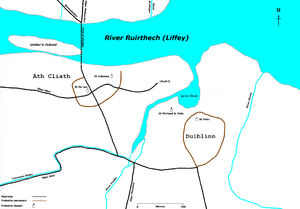
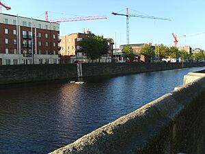
The name "ford of hurdles" – Áth Cliath in Irish – suggests that people built a path of woven branches, or "hurdles," to help travelers cross the river without getting wet at low tide. They might have used Usher's Island in the middle of the river. It's also possible that hurdles were used as fish traps along the riverbanks. The ford was probably about 100 meters west of where Father Mathew Bridge is now. But without more archaeological proof, we can only guess its exact nature and location.
In ancient times, the lower part of the Liffey River was thought to be a border between two regions, Leinster and Mide. Áth Cliath, which belonged to Leinster, must have been an important trading place because of its location on this border.
Ancient Roads Leading to Dublin
It's also interesting that four of the five main ancient Irish highways met at the site of the medieval city. These roads linked Dublin with the five regions of ancient Ireland: Ulster and Mide to the north, Connacht to the west, Munster to the southwest, and Leinster to the south.
- Slige Midluachra – This road ran southeast from Ulster. It crossed the Liffey at the ford of hurdles. Parts of this road can still be seen in some of Dublin's modern streets, like Bow Street and Francis Street.
- Slige Mhór – This was the "great highway" that ran from east to west across the whole country. Its eastern end was just beyond Áth Cliath. Today, James's Street and Thomas Street follow its path.
- Slige Chualann – This road ran south from Áth Cliath. It was named after Cualu, the area where Dublin was located. Long parts of this road still exist today. In the modern city, its early path is followed by New Street and Harold's Cross Road. The Wicklow Way, a long walking trail, follows much of this old road.
- Slige Dála – This road came to Áth Cliath from the southwest. Its end was at the southern part of the religious settlement of Dubhlinn. Today, you can find it in Cork Street and The Coombe.
We don't know exactly when these roads were built, but an old text from around 700 AD confirms they existed early on. Áth Cliath was centered where the Slige Midluachra and Slige Mhór roads crossed. After Christianity arrived, a small church might have been built here. Another early church, dedicated to St Columba, was where St Audoen's Church is now. This is thought to be the city's oldest church site. The name Cornmarket suggests there was a market nearby.
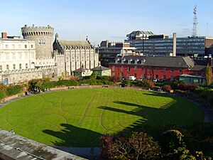
An early fort, or ráth, might have been built where Dublin Castle is today. This would have been easy to defend, as it was the highest point and surrounded by water on three sides. This could explain why the Slige Mhór road went past Áth Cliath.
The name Baile Átha Cliath was first written down in 1365. The Irish word "baile" means "town." Historians often call the western settlement "Áth Cliath" to tell it apart from "Duiblinn."
Duiblinn: The Black Pool Settlement
By the early 600s, Áth Cliath had a neighbor: a large and important religious settlement about half a kilometer to the southeast. This place was called Duiblinn (Modern Irish Dubhlinn, meaning "Blackpool"). It got its name from a dark tidal pool in the River Poddle nearby. This pool is gone now, but its location is marked by the Coach House and Castle Gardens behind Dublin Castle.
Duiblinn was one of the biggest religious settlements in Ireland at the time. It covered about 5 hectares. Its pear shape can still be seen in the layout of some modern streets, like St Peter's Row and Upper and Lower Stephen Street. A local church, St Peter's on The Mount, might have replaced a much older church in this area.
However, recent digs at another church, St Michael le Pole, suggest that Duiblinn might have been located there instead. As its name "St Michael of the Pool" suggests, it overlooked the "Black Pool." This church had a round tower and was known to exist by the late 600s.
Graves from the 700s have been found at another early church, St Bride's, on the corner of Bride Road and Bride Street. This site might have been part of the same religious area as St Michael le Pole's.
Duiblinn was likely the main place of worship for a local group called the Uí Fergusa. Several old writings mention Abbots and Bishops of Duiblinn. Some important figures include:
- St Beraidh (†650) – Described as Abbot of Dublin.
- St Livinus (†663) – An Irish saint who became Bishop of Ghent. He was martyred (killed for his beliefs).
- St Disibod (619–700) – He founded a community in Germany.
- St Rumold (†775) – An Irish or English monk who preached in Europe and was martyred. He is the patron saint of Mechelen.
- St Sedulius (†785) – Bishop or Abbot of Dublin.
According to old records, St Sedulius was the last Abbot of Dublin mentioned before a big change. In 795, just ten years after his death, the Vikings, or Norsemen, launched their first attack on Ireland. A new era in Dublin's history was about to begin!
See also
- History of Dublin
- Early Scandinavian Dublin
 | Anna J. Cooper |
 | Mary McLeod Bethune |
 | Lillie Mae Bradford |


