History of Staffordshire facts for kids
Staffordshire is a county in the West Midlands region of England. It's a "landlocked" county, meaning it doesn't have a coastline. Staffordshire shares borders with several other counties. These include Cheshire to the north-west, Derbyshire and Leicestershire to the east, and Warwickshire to the south-east. It also borders the West Midlands and Worcestershire to the south, and Shropshire to the west.
Historically, Staffordshire was larger. It used to include the cities of Wolverhampton, Walsall, and West Bromwich. In 1974, these areas became part of the new West Midlands authority. Later, in the 1990s, the city of Stoke-on-Trent also became a separate "unitary authority." This means it manages its own local services. However, Stoke-on-Trent is still considered part of Staffordshire for special events and traditions.
The historic county of Staffordshire covers about 781,000 acres (1,250 square miles). In 1801, the first census showed it had a population of 239,153 people.
Contents
- Ancient Times: Iron Age and Roman History
- Anglo-Saxon Era: The Staffordshire Knot
- Norman Conquest: Changes After 1066
- Later Middle Ages: Wars and Divisions
- Hundreds of Staffordshire: Old Divisions
- English Civil War: A County Divided
- Industrial History: From Farms to Factories
- Parliamentary Representation: A Voice in Government
- Historical Buildings and Sites: Ancient Wonders
- See also
Ancient Times: Iron Age and Roman History
You can find signs of early British people in many parts of Staffordshire. Many ancient burial mounds, called barrows, have been explored. Inside these barrows, archaeologists have found human bones, pots, brooches, stone hammers, and other old items. For example, near Wetton in Dovedale, twenty-three barrows were opened. British ornaments have also been found in Needwood Forest.
The Romans also left their mark. Several Roman camps still exist, such as Knave's Castle. This camp is located on Watling Street, an ancient Roman road, near Brownhills.
Anglo-Saxon Era: The Staffordshire Knot
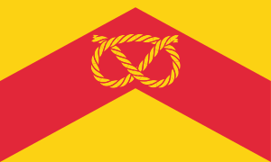
The famous Staffordshire Knot is a special symbol for the county. You can see it on an Anglian stone cross. This cross dates back to around the year 805 and still stands in Stoke churchyard.
The Knot might be an old symbol from Mercia, an ancient Anglo-Saxon kingdom. Or, it could have come from Irish Christianity. Irish monks from Lindisfarne brought Christianity to Staffordshire around AD 650.
In the 6th century, a group of Angles invaded the area that is now Staffordshire. They settled near Tamworth, which later became an important home for Mercian kings. The Danes often attacked this area. However, in 910, they were defeated at Tettenhall and again at Wednesfield.
After Edward the Elder finally drove the Northmen out of Mercia, the land became a "shire." This happened around the fortified town of Stafford, which Edward had built in 914. Stafford was a key military spot for crossing the Trent. The county of Staffordshire likely began in the decade after 913. It was first mentioned by name in the Anglo-Saxon Chronicle in 1016.
Norman Conquest: Changes After 1066
When William the Conqueror took over England in 1066, Staffordshire resisted him. As a result, the county faced harsh punishments. Many lands were taken away. The Domesday Survey, a detailed record from 1086, shows how empty and poor Staffordshire was. It had only 64 mills, while a smaller county like Dorset had 272.
After the Conquest, no English person was allowed to keep important estates. The main landowners were Norman lords. Families like the Ferrers and Staffords played a big role in Staffordshire's history for a long time. At the time of the survey, Burton was the only monastery in Staffordshire. However, other religious places existed in towns like Stafford, Wolverhampton, and Lichfield.
Later Middle Ages: Wars and Divisions
In the 13th century, Staffordshire was divided into church areas called deaneries. These included Stafford, Newcastle, Alton, and Leek. Over time, these divisions changed and grew. By 1896, there were many more deaneries, and two main archdeaconries: Stafford and Stoke-on-Trent.
During the wars of King Henry III, many important families in Staffordshire supported Simon de Montfort. In 1263, Prince Edward attacked the lands of Earl Robert Ferrers and destroyed Tutbury Castle.
Later, during the Wars of the Roses, Eccleshall was a base for Queen Margaret. In 1459, the Lancastrians were defeated at the Battle of Blore Heath in Staffordshire.
Hundreds of Staffordshire: Old Divisions

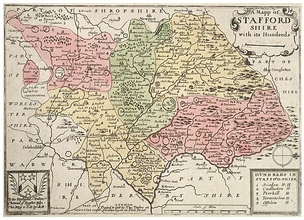
Since the Domesday Survey, Staffordshire has been divided into five areas called "hundreds." These divisions have stayed mostly the same for centuries. The five hundreds are Totmonslow, Pirehill, Offlow, Cuttleston, and Seisdon.
The way Staffordshire was divided into hundreds is quite stable compared to counties further south and west. Staffordshire's hundreds are also much larger, especially in the north. This is because northern Staffordshire was mostly moorland, which wasn't attractive to early settlers. The meeting places for the northern hundreds were in the very south of those areas.
Southern Staffordshire had many forests, like Kinver Forest. Large parts of the central hundreds, Cuttleston and Offlow, were covered by Cannock Forest. This means the areas that could be farmed were much smaller in early times.
English Civil War: A County Divided
During the English Civil War in the 1600s, Staffordshire mostly supported the Parliament. The county was placed under the command of Lord Brooke. However, some towns like Tamworth, Lichfield, and Stafford supported King Charles.
Lichfield Cathedral was attacked in 1643. In the same year, the Royalists won a battle at Hopton Heath, but they lost their leader, the Earl of Northampton. Much later, in 1745, the Young Pretender (a claimant to the throne) marched as far as Leek in Staffordshire.
Industrial History: From Farms to Factories
In Norman times, much of Staffordshire was wild and uncultivated land. But the moorlands in the north were great for sheep. By the 14th century, Wolverhampton was an important town for wool.
In the 13th century, people started mining coal and iron in places like Walsall. By the 15th century, coal and iron mining were very common. In the 17th century, the north of the county produced coal, lead, copper, and marble. The rich meadows supported large dairy farms. The southern woodlands provided timber, salt, and alabaster.
The clothing trade grew in towns like Tamworth, Burton, and Newcastle-under-Lyme. Hemp and flax, used for making cloth, were grown across the county. The pottery industry in Staffordshire has a long history. It became famous in the 18th century thanks to Josiah Wedgwood. He greatly improved how pottery was made.
Parliamentary Representation: A Voice in Government
Staffordshire first sent two representatives to Parliament in 1290. By 1295, the town of Stafford also sent two members. Later, Lichfield (1304) and Newcastle-under-Lyme (1355) also gained representatives. Tamworth followed in 1562.
Over time, laws like the Reform Act of 1832 changed how many members Staffordshire sent to Parliament. The county began sending four members. Towns like Stoke-upon-Trent and Wolverhampton each sent two members, and Walsall sent one. The Act of 1867 further increased the county's representation to six members.
Historical Buildings and Sites: Ancient Wonders
Staffordshire has many interesting old churches, especially in its larger towns. The beautiful Lichfield Cathedral is one example. Other notable churches include those in Eccleshall, Leek, Penkridge, St Mary's at Stafford, Tamworth, and Tutbury. St Peter's at Wolverhampton is also very old.
Checkley church, south of Cheadle, has lovely Norman and Early English designs. It also has carved stones from before the Norman Conquest. Armitage church, south-east of Rugeley, shows good Norman work. Brewood church, south-west of Penkridge, is an example of Early English style.
While most old monastery ruins are small, the Cistercian abbey of Croxden, north-west of Uttoxeter, has impressive Early English remains. At Ranton, west of Stafford, you can still see the tower of an Augustinian monastery.
For medieval castles, there are Stafford, Tamworth, and Tutbury. Chartley Castle, north-east of Stafford, dates from the 13th century. It also has a timbered hall and a special breed of wild cattle in its park.
Many grand houses also exist. Beaudesert, south of Rugeley, is a beautiful Elizabethan mansion. In the south-west, near Stourbridge, are Enville, a Tudor house, and Stourton Castle. Reginald, Cardinal Pole, an important historical figure, was born at Stourton Castle in 1500. Other famous modern estates include Ingestre, Ilam Hall, Alton Towers, Shugborough, Patteshull, Keele Hall, and Trentham.
See also
- Lost houses of Staffordshire
 | Leon Lynch |
 | Milton P. Webster |
 | Ferdinand Smith |


