
Long Beach Township, New Jersey facts for kids
Quick facts for kids
Long Beach Township, New Jersey
|
||
|---|---|---|
|
Township
|
||

Holgate Beach, part of the Edwin B. Forsythe National Wildlife Refuge, managed by the U.S. Fish and Wildlife Service, at the southern tip of Long Beach Island, within Long Beach Township, Ocean County
|
||
|
||

Location of Long Beach Township in Ocean County highlighted in yellow (right). Inset map: Location of Ocean County in New Jersey highlighted in black (left).
|
||

Census Bureau map of Long Beach Township, New Jersey
|
||

Long Beach Township, New Jersey
Location in Ocean County, New Jersey

Long Beach Township, New Jersey
Location in New Jersey

Long Beach Township, New Jersey
Location in the United States
|
||
| Country | ||
| State | ||
| County | ||
| Incorporated | March 23, 1899 | |
| Government | ||
| • Type | Walsh Act | |
| • Body | Board of Commissioners | |
| Area | ||
| • Total | 21.99 sq mi (56.95 km2) | |
| • Land | 5.45 sq mi (14.11 km2) | |
| • Water | 16.54 sq mi (42.84 km2) 75.22% | |
| Area rank | 124th of 565 in state 13th of 33 in county |
|
| Elevation | 0 ft (0 m) | |
| Population
(2020)
|
||
| • Total | 3,153 | |
| • Estimate
(2023)
|
3,145 | |
| • Rank | 442nd of 565 in state 18th of 33 in county |
|
| • Density | 578.7/sq mi (223.4/km2) | |
| • Density rank | 434th of 565 in state 27th of 33 in county |
|
| Time zone | UTC−05:00 (Eastern (EST)) | |
| • Summer (DST) | UTC−04:00 (Eastern (EDT)) | |
| ZIP Code |
08008
|
|
| Area code(s) | 609 exchanges: 207, 361, 492, 494 | |
| FIPS code | 3402941250 | |
| GNIS feature ID | 0882066 | |
| Website | ||

Long Beach Township is a special type of town, called a Township, located on the famous Jersey Shore. You can find it in southeastern Ocean County, in the state of New Jersey.
As of the 2020 United States census, about 3,153 people live here. This was a small increase from the 2010 census. Most of Long Beach Township is on Long Beach Island. This is a long, thin island that protects the mainland from the Atlantic Ocean.
In the summer, the island becomes very busy! Its population can grow to as many as 130,000 people. This includes both part-time residents and many tourists who come to visit.
In October 2012, Hurricane Sandy hit Long Beach Township very hard. The storm caused a lot of damage to homes and businesses. Streets were covered with sand, and many areas flooded. The mayor estimated the repairs could cost up to $1 billion across the island. People had to leave their homes for nearly two weeks. The township created a special fund to help residents recover.
Long Beach Township officially became a township on March 23, 1899. It was formed from parts of several other townships nearby. Over time, some parts of it became new towns like Barnegat Light and Ship Bottom. The name "Long Beach" comes from the long stretch of the island along Barnegat Bay.
Contents
Exploring Long Beach Township's Geography
Long Beach Township covers a total area of about 21.99 square miles (56.95 square kilometers). Most of this area, about 75%, is water. The land area is around 5.45 square miles (14.11 square kilometers).
Communities and Neighborhoods
Many small communities and neighborhoods are part of Long Beach Township. Some of these include:
- Bay Vista
- Beach Haven Crest
- Beach Haven Gardens
- Beach Haven Heights
- Beach Haven Inlet
- Beach Haven Park
- Beach Haven Terrace
- Brant Beach
- Brighton Beach
- Haven Beach
- High Bar Harbor
- Holgate
- Loveladies
- North Beach
- North Beach Haven
- Peahala Park
- South Beach Haven
- Spray Beach
- The Dunes
The township is actually split into four separate land areas. The largest area, where most people live, is north of Beach Haven and south of Ship Bottom. The Holgate area is south of Beach Haven. Much of Holgate is a special wildlife preserve. Loveladies and High Bar Harbor are the northernmost parts, located between Harvey Cedars and Barnegat Light.
Neighboring Towns
Long Beach Township shares borders with several other towns in Ocean County. These include:
- Barnegat Light
- Barnegat Township
- Beach Haven
- Eagleswood Township
- Harvey Cedars
- Little Egg Harbor Township
- Ocean Township
- Ship Bottom
- Stafford Township
- Surf City
Understanding the Population of Long Beach Township
| Historical population | |||
|---|---|---|---|
| Census | Pop. | %± | |
| 1900 | 152 | — | |
| 1910 | 107 | * | −29.6% |
| 1920 | 106 | −0.9% | |
| 1930 | 355 | * | 234.9% |
| 1940 | 425 | 19.7% | |
| 1950 | 840 | 97.6% | |
| 1960 | 1,561 | 85.8% | |
| 1970 | 2,910 | 86.4% | |
| 1980 | 3,488 | 19.9% | |
| 1990 | 3,407 | −2.3% | |
| 2000 | 3,329 | −2.3% | |
| 2010 | 3,051 | −8.4% | |
| 2020 | 3,153 | 3.3% | |
| 2023 (est.) | 3,145 | 3.1% | |
| Population sources: 1900–2000 1900–1920 1900–1910 1910–1930 1940–2000 2000 2010 2020 * = Lost territory in previous decade. |
|||
In 2010, the census counted 3,051 people living in Long Beach Township. There were 1,539 households, which are groups of people living together. About 943 of these were families.
Most of the people living here, about 97%, were White. A small number of people were Black, Native American, or Asian. About 4% of the population identified as Hispanic or Latino.
The average age of people in Long Beach Township was 61.3 years old. This means it has an older population compared to many other places. About 9.9% of the people were under 18 years old.
Fun Activities and Community Life
Long Beach Township offers various ways for people to enjoy themselves and be part of the community.
Long Beach Township Beach Patrol

The Long Beach Township Beach Patrol (LBTBP) started in 1936. Their main job is to keep people safe on the 12 miles of beaches in the township. They also help protect the environment.
The patrol has cool programs like the Lifeguard in Training (LIT) Program. They also hold yearly competitions and events for lifeguards. The LBTBP serves six communities from north to south: Loveladies, North Beach, Brant Beach, Beach Haven Crest, Spray Beach, and Holgate.
St. Francis of Assisi Parish and Community Center
The Saint Francis of Assisi Parish is a church group that serves Long Beach Township. It includes four churches and a community center. The church follows traditional Franciscan Catholic beliefs.
The St. Francis Community Center opened in 1972. It offers many programs for everyone. These include sports, services for older adults, educational classes, and chances to volunteer.
Learning and Schools in Long Beach Township
Students in Long Beach Township attend public schools in two different districts, depending on their grade level.
Elementary and Middle School Education
For students from pre-kindergarten through sixth grade, they go to schools in the Long Beach Island Consolidated School District. This district also serves students from nearby towns like Barnegat Light, Harvey Cedars, Ship Bottom, and Surf City.
The district has two schools:
- Ethel Jacobsen School in Surf City: This school teaches students from pre-kindergarten to second grade.
- Long Beach Island Grade School in Ship Bottom: This school is for students in grades 3–6.
High School Education
Students in seventh through twelfth grade attend schools in the Southern Regional School District. This district includes students from the Long Beach Island towns, plus Beach Haven and Stafford Township. Students from Ocean Township also attend these schools.
The high school district has two schools, both located in Manahawkin:
- Southern Regional Middle School: This school is for students in grades 7–8.
- Southern Regional High School: This school is for students in grades 9–12.
Catholic School Options
There is also a private Catholic school in the area called St. Mary Academy. It is located near Manahawkin and serves students from kindergarten through eighth grade.
Getting Around Long Beach Township
Roads and Highways
_at_21st_Street_in_Long_Beach_Township,_Ocean_County,_New_Jersey.jpg)
Long Beach Township has about 66 miles of roads. Most of these roads are managed by the township itself. There are no major highways like Interstates or U.S. routes directly in the township.
The main road you'll use to get around is County Route 607, also known as Long Beach Boulevard.
Public Transportation
There are a few ways to get around using public transport:
- Ocean Ride: This local bus service has a route called OC9 LBI North / South.
- LBI Shuttle: This shuttle runs along Long Beach Boulevard. It's free and comes every 5 to 20 minutes from 10:00 AM to 10:00 PM. It connects many communities on Long Beach Island.
- Surf Line Bus: During the summer, this bus service offers trips from New York City to Long Beach Island on Friday nights, returning on Sunday nights.
- Transportazumah: This service also provides daily bus trips to and from New York during the summer.
Weather and Environment
Climate and Temperatures
Long Beach Township has a humid subtropical climate. This means it has hot, somewhat humid summers and cool winters. It rains throughout the year.
In summer, a cool ocean breeze often blows in the afternoon. However, it can sometimes get very hot and humid. In winter, it can get very cold and windy. The area usually gets about 12 to 18 inches of snow each winter. February is often the snowiest month.
Ocean Water Temperatures
The ocean water temperature near Long Beach Township changes throughout the year. It's coldest in February, around 35°F (2°C). It gets warmest in August, reaching about 73°F (23°C).
Local Plant Life
The natural plant life in Long Beach Township would mostly be Northern Cordgrass. This type of grass grows in coastal areas and forms a kind of Coastal Prairie.
Images for kids
-
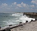
Holgate Beach, part of the Edwin B. Forsythe National Wildlife Refuge, managed by the U.S. Fish and Wildlife Service, at the southern tip of Long Beach Island, within Long Beach Township, Ocean County
-
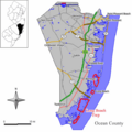
Location of Long Beach Township in Ocean County highlighted in yellow (right). Inset map: Location of Ocean County in New Jersey highlighted in black (left).
-
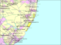
Census Bureau map of Long Beach Township, New Jersey
See also
 In Spanish: Municipio de Long Beach (Nueva Jersey) para niños
