
Hot Spring County, Arkansas facts for kids
Quick facts for kids
Hot Spring County
|
|
|---|---|
| County of Hot Spring | |

Main façade of the Hot Spring County Courthouse
|
|

Location within the U.S. state of Arkansas
|
|
 Arkansas's location within the U.S. |
|
| Country | |
| State | |
| Established | November 2, 1829 |
| Named for | hot springs at Hot Springs, Arkansas, which were formerly in the county. |
| Seat | Malvern |
| Largest city | Malvern |
| Area | |
| • Total | 622.16 sq mi (1,611.4 km2) |
| • Land | 614.94 sq mi (1,592.7 km2) |
| • Water | 7.22 sq mi (18.7 km2) 1.16%% |
| Population
(2020)
|
|
| • Total | 33,040 |
| • Density | 53.105/sq mi (20.504/km2) |
| Time zone | UTC−6 (Central) |
| • Summer (DST) | UTC−5 (CDT) |
| ZIP Codes |
71901, 71913, 71921, 71923, 71929, 71933, 71941, 71943, 71964, 72084, 72104, 72167
|
| Congressional district | 4th |
Hot Spring County is a county in the state of Arkansas, USA. In 2020, about 33,040 people lived there. The main city and county seat is Malvern. The county was created on November 2, 1829. It was named after the famous hot springs in Hot Springs, Arkansas, which used to be part of this county.
For almost 80 years, Hot Spring County had a rule that did not allow the sale of alcohol. This rule was changed in November 2022, when people voted to allow alcohol sales across the county.
Hot Spring County is part of the Malvern, AR area, which is also connected to the larger Hot Springs-Malvern area.
Contents
Geography and Nature
Hot Spring County is located in Southwest Arkansas. This area is known for its Ouachita Mountains, deep valleys, and many forests. Most of Hot Spring County is in the mountainous part of this region. It is covered with forests of hardwood and pine trees. The Ouachita River flows through the county, dividing it roughly in half.
The county covers about 622 square miles (1,611 square kilometers). Most of this area is land, with a small part being water. Hot Spring County is about 47 miles (76 km) southwest of Little Rock. It is surrounded by six other counties, including Garland County to the north and Clark County to the south.
Parks and Wildlife Areas
Hot Spring County is home to two state parks: DeGray Lake Resort State Park and Lake Catherine State Park. These parks are great for outdoor activities. There are also two Wildlife Management Areas (WMAs), DeGray Lake WMA and Jack Mountain WMA. These areas are managed by the Arkansas Game and Fish Commission to protect wildlife.

DeGray Lake Resort State Park is a large park in the southwest part of the county. It is Arkansas's only resort state park. It has a lodge with 94 rooms, a restaurant, and an 18-hole golf course. You can also enjoy camping, hiking, fishing, boating, and horseback riding here. The park is managed by the Arkansas Department of Parks and Tourism.
Near Malvern, you'll find Lake Catherine State Park. This smaller park is on the west side of Lake Catherine. It offers 20 cabins, some of which were built in the 1930s by the Civilian Conservation Corps. There are also 70 campsites. In the summer, you can rent boats, visit the visitor center, or go on guided tours.
Population and People
Between 2000 and 2010, Hot Spring County grew quite a bit. The number of people living there increased from 30,353 to 32,923. This was an 8.5% increase. People's incomes also went up, and fewer people lived in poverty.
As of the 2020 United States census, there were 33,040 people living in Hot Spring County. There were 12,599 households and 8,857 families. Most people in the county are White (79.36%), followed by Black or African American (10.44%). About 3.83% of the population is Hispanic or Latino.
In 2010, the average household had about 2.48 people. The average family had about 2.94 people. The population was spread out by age:
- 23.3% were under 18 years old.
- 24.3% were between 25 and 44 years old.
- 15.7% were 65 years or older.
The average age in the county was 40.1 years.
Education
Most adults in Hot Spring County have a high school degree. About 84.8% of people over 25 years old have finished high school. This is similar to the average for Arkansas. However, fewer people in Hot Spring County have a bachelor's degree or higher (13.0%) compared to the state and national averages.
Schools in Hot Spring County

There are five main public school districts in Hot Spring County:
- Malvern School District (the largest)
- Bismarck School District
- Ouachita School District
- Glen Rose School District
- Magnet Cove School District
Students in these districts can graduate from high schools like Malvern High School or Bismarck High School. All these high schools offer special courses called Advanced Placement (AP) courses. These courses can help students earn college credit.
Some residents might also attend schools in the Centerpoint School District or Poyen School District.
Colleges and Universities
Hot Spring County has one college, ASU Three Rivers, which is a public community college in Malvern. Other colleges nearby include National Park College in Hot Springs and two four-year universities in Arkadelphia: Henderson State University and Ouachita Baptist University.
Libraries
The Malvern-Hot Spring County Library is located in downtown Malvern. It was started in 1928. The library offers books, e-books, movies, and help with research. They also have special services for kids and for people interested in genealogy (family history).
Communities
Hot Spring County has two cities and four towns. The largest city and the county seat is Malvern. It is located in the northeast part of the county. In 2010, Malvern had a population of 10,318 people. Close to Malvern are the towns of Rockport and Perla.
Other towns in the southern part of the county include Donaldson, Friendship, and Midway. These towns each have fewer than 400 people. Magnet Cove used to be a town, but it stopped being an official town in 2006.
Many smaller communities and old "ghost towns" are also found in Hot Spring County. In the past, people often settled in small groups rather than in official towns. Some of these communities, like Jones Mill, might have a post office or a few buildings. Others are just a few houses at a crossroads.
Cities
Towns
Census Designated Places
These are areas that are like towns but are not officially incorporated as cities or towns.
Other Unincorporated Communities
- Abco
- Antioch
- Beaton
- Bonnerdale
- Brown Springs
- Butterfiield
- Caney
- Central
- De Roche
- Diamondhead
- Faber
- Gifford
- Glen Rose
- Harp
- Lambert
- Landers
- Lono
- Morning Star
- Mount Moriah
- Oak Bower
- Oak Grove
- Old De Roche
- Oma
- Point Cedar
- Rolla
- Saginaw
- Shorewood Hills
- Social Hill
- Whittington
- Witherspoon
Transportation
Air Travel
Hot Spring County has one public airport called Malvern Municipal Airport, located southeast of Malvern. It is mainly used for general aviation, like private planes. For bigger flights, the closest airport is Clinton National Airport in Little Rock.
Main Roads
Many important highways pass through Hot Spring County, connecting it to other parts of Arkansas and beyond.
 Interstate 30
 U.S. Highway 67
 U.S. Highway 70
 U.S. Highway 270
 Highway 7
 Highway 9
 Highway 51
 Highway 84
 Highway 128
 Highway 171
 Highway 222
 Highway 283
 Highway 347
Images for kids
-
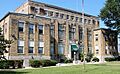
Main façade of the Hot Spring County Courthouse
-
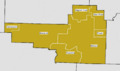
Public school district boundaries in Hot Spring County as of July 2016
-
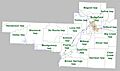
Townships in Hot Spring County, Arkansas as of 2010

See also
 In Spanish: Condado de Hot Spring para niños
