
Hurricane Cristobal facts for kids
| Category 1 hurricane (SSHWS/NWS) | |

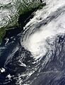
Hurricane Cristobal near peak intensity off the U.S. East Coast on August 28
|
|
| Formed | August 23, 2014 |
|---|---|
| Dissipated | September 2, 2014 |
| (Extratropical after August 29) | |
| Highest winds | 1-minute sustained: 85 mph (140 km/h) |
| Lowest pressure | 965 mbar (hPa); 28.5 inHg |
| Fatalities | 7 total |
| Damage | Unknown |
| Areas affected | Puerto Rico, Hispaniola, Turks and Caicos Islands, East Coast of the United States, Bermuda, Iceland |
| Part of the 2014 Atlantic hurricane season | |
Hurricane Cristobal was a strong Atlantic storm in late August and early September 2014. It traveled a long way, affecting many places from Puerto Rico to Iceland. The storm began on August 23 near the Caicos Islands as a tropical wave.
Cristobal slowly grew stronger as it moved north. It passed between Bermuda and North Carolina on August 27. The next day, it became a Category 1 hurricane, which was its strongest point. As it moved into colder areas, Cristobal changed into a different type of storm called an extratropical cyclone on August 29. It kept much of its power as it sped across the northern Atlantic Ocean and reached Iceland on September 1.
Before it was even named, Cristobal caused heavy rain in Puerto Rico. This led to widespread flooding and landslides. Many rivers overflowed. The storm then brought more heavy rain to Hispaniola, causing at least four deaths in Haiti and the Dominican Republic. Floods damaged over 800 homes and cut off 23 communities in the Dominican Republic. About 640 families had to leave their homes in Haiti. Another person died in the Turks and Caicos Islands due to flooding.
Along the East Coast of the United States, the hurricane created big waves and dangerous rip currents. Two swimmers died in Maryland and New Jersey. Lifeguards had to rescue many people. Later, when Cristobal was an extratropical storm, it brought heavy rain and strong winds to Iceland. This caused flooding around the capital city of Reykjavík.
Contents
How Hurricane Cristobal Formed and Moved

Hurricane Cristobal started as a tropical wave that left Africa on August 14. This wave carried a lot of clouds. On August 23, it officially became a tropical depression south of the Caicos Islands. It slowly moved north-northwest.
The storm faced moderate wind shear, which made it hard for it to get organized. This meant the storm only slowly got stronger. On August 24, it became Tropical Storm Cristobal. It was located just north of Mayaguana in the Bahamas.
Cristobal moved slowly and unevenly. Most of its strong thunderstorms were away from its center. On August 25, it turned toward the north-northeast. Even though it looked a bit messy on satellite, Cristobal became a Category 1 hurricane on August 26. This was confirmed by planes flying into the storm.
For the next couple of days, dry air kept Cristobal from getting much stronger. Its cloud pattern changed, and on August 27, it looked a bit like a subtropical cyclone. However, later that day, it started to look more organized. It was then located between Bermuda and Cape Hatteras, North Carolina. Cristobal then sped up toward the northeast.
On August 28, a clear eye appeared in the center of the storm. Cristobal reached its strongest point at 6 PM UTC, with winds of 85 mph (140 km/h). It was about 490 miles (790 km) south of Halifax, Nova Scotia. Soon after, the hurricane began to weaken. It moved over much colder waters and met more dry air. This started its change into an extratropical cyclone.
By August 29, Cristobal had lost its tropical features. However, it kept much of its strength. It maintained hurricane-force winds until August 30. The storm continued to speed northeast across the northern Atlantic. It made landfall on Iceland on September 1. Cristobal then merged with another storm system north of Iceland the next day.
Impacts of Hurricane Cristobal
Effects in the Caribbean Islands

When Cristobal's parent weather system moved over Puerto Rico, it brought very heavy rains. Some areas received more than 10 inches (250 mm) of rain. A rain gauge near Tibes recorded a peak of 13.21 inches (336 mm). The Luis Muñoz Marín International Airport near San Juan reported 5.52 inches (140 mm).
In total, 19 rivers in Puerto Rico reached minor flood stage. Five rivers reached moderate flood stage. Some of these rivers flooded roads and towns. The heavy rains also caused many landslides. At least one landslide forced a family to leave their home. The floods cut electricity to nearly 17,000 homes. About 7,000 people lost clean drinking water because 18 water treatment plants stopped working. However, the rains also helped refill water reservoirs after a very dry summer. Only the northwest part of Puerto Rico avoided major water problems. Strong winds caused small damage to trees. The U.S. Virgin Islands also had moderate to heavy rain.
The island of Hispaniola also suffered from damaging rains. La Romana, Dominican Republic, received 5.04 inches (128 mm) of rain in 24 hours. This caused destructive flooding. The floods cut off 23 towns from the outside world. More than 800 homes were damaged or destroyed, especially in the eastern and northeastern parts of the country. Over 4,100 people had to leave their homes. In Santo Domingo Province, three people were rescued from their car after trying to cross the flooded Isabela River. Two people died in the Dominican Republic.
In neighboring Haiti, floods completely destroyed four homes and badly damaged 28 others. About 640 families were left without a home for a while. At least two people in Haiti were swept away by fast-moving water. Many others were hurt.
Soon after the storm formed, tropical storm warnings were put in place for parts of the Bahamas and the Turks and Caicos Islands. Heavy rain fell in the region. The island of Providenciales received 10.9 inches (277 mm) of rain, and one person drowned there. On North Caicos, floodwaters were 5 feet (1.5 m) deep, blocking roads to some communities. The Governor of the Turks and Caicos Islands, Peter Beckingham, said there was "extensive damage" to people's homes and belongings.
Impacts Elsewhere
A tropical storm watch was issued for Bermuda on August 25. It was removed about three days later. Two cruise ships left Bermuda early to avoid the storm. Two others delayed their visits. The threat of the storm also caused ferry services to stop. Cristobal passed well to the northwest of Bermuda. It brought breezy conditions and higher waves to the island.
The hurricane caused big waves and rip currents along the East Coast of the United States. This led to many swimming restrictions and bans. A teenager died in a drowning accident at Ocean City, Maryland. This happened less than an hour after lifeguards finished their duty. In one day, the Ocean City Beach Patrol rescued about 120 people caught in rip currents. Off the coast, a 17-foot (5.2 m) boat flipped over. The Coast Guard had to rescue the three people on board. Another young male drowned at Sandy Hook, New Jersey. A wave reportedly knocked him down, and a rip current pulled him out. Dangerous swimming conditions also reached beaches in New England. This led to many lifeguard rescues there.
In southern Iceland, the leftover storm (extratropical Cristobal) brought strong winds and heavy rain. This caused a lot of flooding in the capital city of Reykjavík. The fire department responded to 37 calls for flooded buildings. Reykjavík Airport and Keflavík International Airport recorded wind gusts up to 58 mph (93 km/h) and 62 mph (100 km/h), respectively. The bad weather made it hard to fly planes to watch the ongoing volcanic eruptions at Bárðarbunga.
Images for kids
-
Hurricane Cristobal near peak intensity off the U.S. East Coast on August 28
-
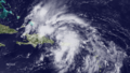
Satellite image of the pre-Cristobal disturbance over Puerto Rico and Hispaniola on August 22
