
Hạ Long Bay facts for kids
| UNESCO World Heritage Site | |
|---|---|
 |
|
| Location | Vietnam |
| Criteria | Natural: vii, viii, ix, x |
| Inscription | 1994 (18th Session) |
| Extensions | 2000, 2023 |
Hạ Long Bay or Halong Bay (Vietnamese: Vịnh Hạ Long) is a famous place in Vietnam. It is a UNESCO World Heritage Site and a popular spot for tourists. The name Hạ Long means "descending dragon." This beautiful bay is in Quảng Ninh province.
Hạ Long Bay is known for its thousands of amazing limestone islands and tall rocks. These islands come in many different shapes and sizes. The bay is part of a bigger area that includes Bai Tu Long Bay and Cát Bà Island. All these areas share similar geology, climate, and culture.
The bay covers about 1,553 square kilometers (599 sq mi). It has 1,969 islands, and most of them are made of limestone. The main part of the bay is 334 square kilometers (129 sq mi) and has 775 islands packed closely together. The limestone here formed over 500 million years! The unique shapes of the islands took 20 million years to form, shaped by the tropical wet climate.
This area has amazing biodiversity. It has a tropical evergreen forest system and a seashore system. Hạ Long Bay is home to 14 types of plants and 60 types of animals found nowhere else.
People have lived in this area for tens of thousands of years. Ancient cultures like Soi Nhụ (around 18,000–7,000 BC), Cái Bèo (7,000–5,000 BC), and Hạ Long (5,000–3,500 years ago) lived here. Hạ Long Bay also played a role in Vietnamese history. Many old items have been found in places like Bài Thơ mountain and Đầu Gỗ cave.
About 500 years ago, a famous Vietnamese poet named Nguyễn Trãi praised Hạ Long Bay's beauty. He called it "a rock wonder in the sky." In 1962, Vietnam recognized Hạ Long Bay as a special national landmark. Later, in 1994, UNESCO added it to the World Heritage List.
Contents
What Does Hạ Long Mean?
The name Hạ Long (下龍) means "descending dragon."
Before the 1800s, this name wasn't used in old books. It was called other names like An Bang or Vân Đồn. The name Hạ Long Bay first appeared on a French map in the late 1800s. A French newspaper even reported, "Dragon appears on Hạ Long Bay."

A local legend tells a story about the name. When Vietnam was a new country, invaders attacked. The gods sent a family of dragons to help. The dragons spat out jewels and jade. These turned into the islands and islets you see today. They formed a great wall against the invaders' ships. After the battle, the dragons loved the Earth so much they decided to live in the bay. The place where the mother dragon landed was named Hạ Long. The place where her children helped her was called Bái Tử Long island. And where their tails splashed was called Bạch Long Vĩ island.
Exploring Hạ Long Bay

Hạ Long Bay has about 1,600 tall, rocky islands. Each one is covered with thick jungle plants and rises straight out of the ocean. Many islands have huge caves inside. Hang Dau Go (Wooden Stakes cave) is the biggest cave in the area. French visitors in the 1800s called it Grotte des Merveilles, meaning "Cave of Wonders." It has three big rooms with many amazing stalactites and stalagmites.
There are two larger islands, Tuần Châu and Cát Bà. People live on these islands, and they have hotels and beaches for tourists. Many smaller islands also have beautiful beaches.

About 1,600 people live on Hạ Long Bay in four fishing villages. These villages include Cua Van, Ba Hang, Cong Tau, and Vong Vieng. People live in floating houses and make a living by fishing and raising sea animals. They catch about 200 types of fish and 450 kinds of mollusks.
Many islands are named after their unusual shapes. For example, there's Voi Islet (elephant), Ga Choi Islet (fighting cock), and Khi Islet (monkey). Out of the hundreds of islands, 989 have been given names. Some islands are also home to birds and land animals like antelopes, monkeys, and lizards.
Most of these islands are like tall, separate towers. They are usually 50 to 100 meters (164 to 328 ft) tall. Another special thing about Hạ Long Bay is the many lakes hidden inside the limestone islands. For example, Dau Be island has six lakes that are completely surrounded by land.
Where is Hạ Long Bay Located?
Hạ Long Bay is in northeastern Vietnam. It stretches along a 120-kilometer (75 mi) coastline. The total area is about 1,553 square kilometers (599 sq mi) with around 2,000 islands. The special area recognized by UNESCO is 434 square kilometers (168 sq mi) with 775 islands.
Climate of the Bay
The climate in Hạ Long Bay is tropical and wet, like many sea islands. It has two main seasons: a hot and moist summer, and a dry and cold winter. The average temperature is between 15-25°C (59-77°F). It rains a lot, with about 2 to 2.2 meters (6.6 to 7.2 ft) of rain each year. The tides here are quite strong, with water levels changing by 3.5 to 4 meters (11.5 to 13 ft).
Who Lives in Hạ Long Bay?

Out of the 1,969 islands, only about 40 have people living on them. These islands vary in size. The main population of Hạ Long Bay is about 1,540 people. They mostly live in floating fishing villages like Cửa Vạn, Ba Hang, and Cặp Dè.
These residents live on boats and rafts. They use tires and plastic jugs to keep their homes floating. They earn money by fishing and raising sea creatures. Fish need to be fed every other day for up to three years before they are sold.
Today, life for these villagers has improved because of tourism. Many now offer rooms for rent, boat tours, and fresh seafood meals to visitors. Even though it's a tough way of life, people in floating villages are often better off than those on other islands in Hạ Long Bay.
The local government is now moving many families from the floating villages to live on the mainland. This helps to protect the bay's environment and gives the families a more stable life. Only a few fishing villages will remain for tourists to visit.
History of Hạ Long Bay

Hạ Long Bay has a long and interesting history, going back thousands of years.
Early Cultures (16,000–3000 BC)
Archaeologists have found signs of very old human life in Hạ Long Bay.
- Soi Nhụ culture (16,000–5000 BC): People from this time lived by the coast. They caught fish and shellfish, and gathered fruits and roots.
- Cái Bèo culture (5000–3000 BC): These people became skilled at using the sea for their needs. This culture connects the older Soi Nhụ people to the later Hạ Long culture.
Battles in the Bay
Hạ Long Bay was important for naval battles in Vietnam's past.
- In 1288, a famous Vietnamese general named Trần Hưng Đạo used the bay's tricky channels. He stopped Mongol ships from sailing up the nearby Bạch Đằng River. He did this by placing sharp wooden stakes in the water at high tide. When the tide went out, the Mongol ships got stuck and were sunk. This was a big victory for Vietnam.
Modern Times
- In 1948, an important agreement was signed in Hạ Long Bay. This led to the raising of a new national flag for Vietnam.
- During the Vietnam War, the channels between the islands were filled with mines by the United States Navy. Some of these mines still pose a danger to ships today.
Geology and How the Bay Formed

In 2000, UNESCO recognized Hạ Long Bay for its amazing geology. It shows how the Earth has changed over millions of years. The bay's unique limestone shapes are very special.
The limestone in Hạ Long Bay formed over 500 million years. The bay's famous cone-shaped hills and tall, isolated limestone towers developed over 20 million years. This happened because of the hot, wet tropical climate. The sea also played a big part in shaping the islands. It carved out notches and caves at the base of the cliffs.
Hạ Long Bay is like a huge, open-air geology museum. It shows how the Earth has evolved over the past 300 million years.
How the Islands Got Their Shapes
Hạ Long Bay is a great example of a "karst landscape" that formed in a warm, wet climate. This means the limestone has been slowly dissolved and shaped by water over a very long time.
The process of how Hạ Long Bay formed can be seen in different stages:
- First, thick layers of limestone formed.
- Then, a hot, wet climate and slow Earth movements helped create the unique shapes.
- Over millions of years, the limestone was carved into cone-shaped hills and tall, separate towers. These towers are what we see as the hundreds of rocky islands today.
- The sea then flooded these areas, covering the plains between the towers. This is what makes Hạ Long Bay so unique.
Many caves in Hạ Long Bay are remnants of older cave systems. Some formed when the land was higher, and others were carved by the sea.
- Old Caves: Caves like Sung Sot, Thien Cung, and Dau Go are examples of very old caves. They formed deep underground when water dissolved the rock.
- Foot Caves: These caves formed at the base of the limestone cliffs. They are often horizontal and show where old water levels were.
- Sea Notch Caves: These are special to Hạ Long Bay. They are formed by seawater dissolving the limestone and waves eroding the cliffs. Many of these caves go all the way through the islands to hidden tidal lakes inside.
Hạ Long Bay's unique tower karst landscape is one of the most extreme forms of limestone development in the world. It's often compared to Yangshuo in China. But Hạ Long Bay is special because the sea has flooded it, making its limestone islands partly shaped by marine erosion. This makes Hạ Long Bay truly one-of-a-kind.
Nature and Wildlife
Hạ Long Bay is home to two main types of ecosystems:
- A tropical, moist, evergreen rainforest ecosystem on the islands.
- A marine and coastal ecosystem in the water.
Seven types of plants are found only in Hạ Long Bay, such as Livistona halongensis. There is also some bioluminescent plankton, which means it glows in the dark!
The many islands in the bay are home to lots of different animals:
- 477 types of flowering plants
- 12 types of ferns
- 20 types of salt marsh plants
- 4 types of amphibia (like frogs)
- 10 types of reptilia (like lizards)
- 40 types of aves (birds)
- 4 types of mammalia (mammals)
Common sea animals found here include:
- cuttlefish
- oysters
- prawns (like shrimp and lobsters)
- sipunculoideas (peanut worms)
- And many types of snails.
In 2023, a new type of sponge, Cladocroce pansinii, was found in the bay's underwater caves.
Protecting the Environment

With more and more tourists visiting, some areas like mangroves and seagrass beds have been cleared. New docks have been built for tourist boats.
Game fishing, especially near coral reefs, can harm endangered fish species.
Local governments and businesses know about these problems. They are taking steps to protect the bay. They are promoting eco-friendly tours and controlling waste from resorts.
Awards and Special Recognitions
Hạ Long Bay has received many important awards and titles:
- In 1962, Vietnam called Hạ Long Bay a 'Renowned National Landscape Monument'.
- In 1994, it became a UNESCO World Heritage Site for its amazing beauty.
- In 2000, UNESCO also recognized it for its outstanding geological value.
- In 2011, the World Monuments Fund added the bay to its list of sites needing protection. They noted that tourism development was a threat.
- In 2012, the New 7 Wonders Foundation named Hạ Long Bay one of the New 7 Wonders of Nature.
- It is also part of the Club of the Most Beautiful Bays of the World.
Conservation Efforts

Hạ Long Bay faces challenges from human activities and natural changes. Cities like Ha Long, Hai Phong, and Hanoi are growing fast. This growth, along with nearby areas in China, puts pressure on the bay. Building new ports and increasing ship traffic can harm the bay. Pollution from factories, too much fishing, and over-development are also big threats.
The expansion of cities, population growth, and building of ports and factories all contribute to pollution. Waste from homes and industries, plus fishing and farming sea animals, are changing the bay's environment. The clear waters are becoming cloudy, and the coral reefs are suffering. Scientists worry that Hạ Long Bay could become "swamped" with pollution. Also, the limestone islands are good for building, so there's a risk of them being mined, which would damage the landscape.
Climate change and rising sea levels are also a threat. They could impact the islands, caves, and wildlife. Vietnam is working to address these challenges.
Sadly, some tourists and even locals don't always protect the environment. There have been reports of littering and even damage to the stalactites in caves. Some caves have even been covered with concrete for events.
What is Being Done to Help?
To protect Hạ Long Bay, the government of Quang Ninh province is taking action:
- They have banned high-speed motorboats for tourists to protect the environment and wildlife.
- Fishing families living in floating villages are being moved to the mainland. This helps keep the water clean.
- Mining for coal and stone in the heritage area has been stopped to prevent pollution.
- Local residents have started volunteer groups to collect and handle waste.
- Since September 1, 2019, Hạ Long City has banned single-use plastic products in the bay. This is a big step to help the environment.
Experts suggest that the protected area should be made even larger. They believe it should include the nearby Cat Ba Archipelago and Bai Tu Long Bay. This would help protect the entire unique marine ecosystem of Vietnam.
Images for kids
-
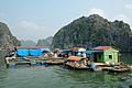
A floating fishing village in Hạ Long Bay
.jpg)
See also
 In Spanish: Bahía de Ha-Long para niños
