
Inchkeith facts for kids
| Gaelic name | Innse Coit |
|---|---|
| Meaning of name | wooded island or Coeddi's island |
| OS grid reference | NT293826 |
| Coordinates | 56°02′00″N 3°08′06″W / 56.033333°N 3.135°W |
| Physical geography | |
| Island group | Islands of the Forth |
| Area | 22.9 hectares (57 acres) |
| Highest elevation | 60 m |
| Administration | |
| Sovereign state | United Kingdom |
| Country | Scotland |
| Council area | Fife |
| Demographics | |
| Population | 0 |
 |
|
| Inchkeith Lighthouse | |
| Location | Inchkeith Fife |
|---|---|
| Coordinates | 56°02′00″N 3°08′12″W / 56.033232°N 3.136643°W |
| Year first constructed | 1804 |
| Automated | 1986 |
| Construction | stone tower |
| Tower shape | cylindrical tower with balcony and lantern attached to a 2-storey keeper’s house |
| Markings / pattern | ochre tower and building, black lantern |
| Height | 19 metres (62 ft) |
| Focal height | 67 metres (220 ft) |
| Intensity | 269,280 candela |
| Range | 22 nautical miles (41 km; 25 mi) |
| Characteristic | Fl W 15s. |
| Admiralty number | A2912 |
| NGA number | 2388 |
| ARLHS number | SCO-107 |
Inchkeith is a small island in the Firth of Forth, Scotland. It is part of the Fife council area. The island's name might come from the old Scottish Gaelic words Innse Coit, meaning "wooded island."
Inchkeith has a long and interesting history. It is close to Edinburgh and has been important for defending the Firth of Forth. It was also home to the Inchkeith Lighthouse. People have lived on Inchkeith on and off for nearly 1,800 years.
Contents
- Island Features: Geography and Climate
- A Look Back: Inchkeith's History
- What's in a Name? The Meaning of Inchkeith
- Early Days: Inchkeith's First Stories
- Island Isolation: Inchkeith as a Quarantine Spot
- A Royal Experiment: James IV and Language
- Wars and Forts: The 16th Century on Inchkeith
- Lighthouses and Defenses: The 19th Century and World War I
- World War II: A Strategic Stronghold
- Modern Times: From Military Base to Private Island
- Images for kids
Island Features: Geography and Climate
Most of Inchkeith island was formed by volcanoes. However, its rocks are quite varied. You can find sandstone, shale, coal, and limestone there. The shale even has many fossils.
The island also has several natural springs, which provide fresh water. Inchkeith gets the least amount of rain in Scotland, with only about 550 millimeters (21.7 inches) each year.
A Look Back: Inchkeith's History
What's in a Name? The Meaning of Inchkeith
The name "Inchkeith" probably comes from the old Scottish Gaelic words Innse Coit. This means "wooded island." The word coit meant "wood" in an old form of Welsh.
It's hard to imagine a rocky island like Inchkeith having many trees. So, some people think the name might come from something else. It could be linked to Saint Adomnán or his friend Coeddi (or Céti), who was a bishop.
Early Days: Inchkeith's First Stories
Not much is known about Inchkeith's very early history. We don't see it mentioned in records until the 12th century. Back then, people had to cross the Firth of Forth by boat. The island was not as isolated as it is today. It was on the ferry routes between Leith and Fife.
Like other nearby islands, Inchkeith was often attacked by English raiders in the 14th century. This was during the Wars of Scottish Independence. The island was right in the path of ships carrying supplies or raiding parties.
We don't know who owned Inchkeith for a long time. But it was owned by the Scottish Crown until it was given to Lord Glamis.
Island Isolation: Inchkeith as a Quarantine Spot
In 1497, Inchkeith was used as a place to isolate people. This happened when there was a serious illness in Edinburgh. People who were sick were sent to the island to keep the illness from spreading.
This happened again in 1589. Passengers from a ship with a serious illness were sent to Inchkeith. More sick people came from the mainland in 1609. In 1799, Russian sailors who died from an illness were buried there.
A Royal Experiment: James IV and Language


During the time of James IV of Scotland, a strange experiment supposedly took place on Inchkeith. A writer named Robert Lyndsay of Pitscottie wrote that in 1493, King James IV sent a woman who could not speak and two babies to the island. He wanted to see what language the children would speak when they grew up, since they would be isolated from everyone else.
The idea was that they might speak the "original" language, or even the "language of God." Pitscottie wrote that some people said the children spoke "good Hebrew." However, there are no other records from that time about this experiment. Most historians today think the story is not true.
Wars and Forts: The 16th Century on Inchkeith
In the 1500s, Inchkeith faced more attacks from the English during a conflict called the Rough Wooing. In 1547, after the Battle of Pinkie, an English general named Duke of Somerset placed soldiers on the island. They built a large square fort where the lighthouse is now.
A French soldier, Jean de Beaugué, wrote that the building work could be seen from Leith. He said that English soldiers and Italian helpers built the fort.
A combined force of French and Scottish soldiers took the island back in June 1549. The next day, Mary of Guise, who was the regent (ruler) of Scotland, visited the island. She saw many dead English soldiers. She even renamed the island "L’Île de Dieu," meaning "The Island of God." Soldiers also called it "L’Île des Chevaux" (The island of horses), but neither name lasted.
After this war, the French occupied the island under Mary of Guise. They made the old English fort even stronger. Italian architect Lorenzo Pomarelli helped with the building.
In 1561, Mary, Queen of Scots made Robert Anstruther the captain of the island. She visited the fort herself. A stone with her initials "MR" (Maria Regina) and the date can still be seen near the lighthouse.
The fort was ordered to be torn down in 1567, after Mary was removed from power. Her opponents did not want a French military presence so close to the capital. The remaining buildings were later used as a prison.
Lighthouses and Defenses: The 19th Century and World War I

In 1803, work began on the Inchkeith Lighthouse. It was designed by Thomas Smith and Robert Stevenson. The lighthouse started working in 1804. It stands 67 meters (220 feet) tall and is an important historic building.
Inchkeith became a key defense point from 1881 until 1956. In 1878, engineers built strong batteries (places for cannons) on three corners of the island. These were like separate fortresses.
Over the years, the island's defenses were updated with bigger and better guns. By the end of World War I, Inchkeith had several large cannons. These included three 9.2-inch guns and six 6-inch guns. Barbed wire was also put along the shore, and small bunkers were built on the beaches.
During World War I, a British battleship called HMS Britannia ran aground at Inchkeith in 1915. It was badly damaged but was later repaired.

World War II: A Strategic Stronghold
Between the two World Wars, the fort and its guns were kept ready. In 1937, Lewis Guns were added for defense against aircraft. In 1938, more buildings were put up for equipment and soldiers.
Inchkeith was the main headquarters for the defenses of the Firth of Forth during both World Wars. Its job was to protect Edinburgh and the naval base from enemy ships. It also protected the Forth Rail Bridge and the Rosyth Dockyard. During World War II, there were barriers and controlled minefields in the water, managed from Inchkeith.
At its busiest during World War II, over 1100 soldiers were stationed on Inchkeith. There were dozens of buildings, gun positions, and control centers. Many of these structures can still be seen today.
Operation Fortitude North: A Clever Trick
Inchkeith played a secret role in Operation Fortitude North during World War II. This was a plan to trick the Germans. It was part of a bigger deception called Operation Bodyguard, which aimed to make the Germans believe the invasion of Normandy would happen later or in a different place.
As part of this trick, a fake army called the "British Fourth Army" was supposedly based in Edinburgh. In March 1944, a special unit from this fake army landed on Inchkeith. They had 22 men, 4 officers, and radio vans. More men arrived in April. They even staged fake attacks on the island's defenses.
The goal was to make German commanders think that an attack on Norway or elsewhere was being planned. This trick worked very well, even though German spy planes didn't fly over Inchkeith until later.
Modern Times: From Military Base to Private Island
After World War II, the defenses on Inchkeith were taken down starting in late 1945. By 1956, all military use of the island had stopped. Ownership of the island then went to the Northern Lighthouse Board.
In 1958, a new foghorn system was installed. In 1986, the lighthouse became automated, meaning it could be controlled from far away by telephone. The lighthouse keepers were no longer needed.
After the lighthouse was automated, the Northern Lighthouse Board sold the island to a businessman named Tom Farmer, who founded Kwik-Fit. Today, you need permission to land on Inchkeith island.
The island used to be a farm, but it is now empty and not looked after.
Images for kids
-
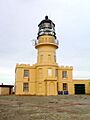
Inchkeith Lighthouse
-
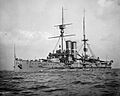
HMS Britannia

