Ingalls, Indiana facts for kids
Quick facts for kids
Ingalls, Indiana
|
|
|---|---|

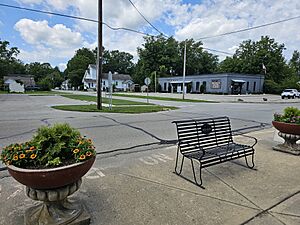
The town hall of Ingalls, Indiana
|
|

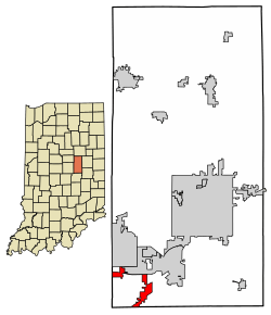
Location in Madison County, Indiana
|
|
| Country | United States |
| State | Indiana |
| County | Madison |
| Township | Green |
| Area | |
| • Total | 3.04 sq mi (7.88 km2) |
| • Land | 3.01 sq mi (7.79 km2) |
| • Water | 0.04 sq mi (0.10 km2) |
| Elevation | 863 ft (263 m) |
| Population
(2020)
|
|
| • Total | 2,223 |
| • Density | 739.52/sq mi (285.49/km2) |
| Time zone | UTC-5 (EST) |
| • Summer (DST) | UTC-5 (EST) |
| ZIP code |
46048
|
| Area code(s) | 317 |
| FIPS code | 18-36342 |
| GNIS feature ID | 2397007 |
Ingalls is a small town in Indiana, United States. It is located in Madison County, within Green Township. The town is part of the larger Indianapolis–Carmel–Anderson metropolitan area. In 2020, about 2,223 people lived there.
Contents
A Look at Ingalls' Past
Ingalls was officially planned and laid out in 1893. This process is called "platting." The town was named after Melville E. Ingalls. He was an important person who worked for the railroad.
Where is Ingalls Located?
Ingalls is found in the southwest part of Madison County. It shares borders with several other towns and cities. To the north, you'll find Pendleton and Lapel. To the west, it's near Noblesville and Fishers in Hamilton County. South of Ingalls is the town of Fortville in Hancock County.
Major Roads and Waterways
U.S. Route 36 goes right through the middle of Ingalls. It is known as Broadway Street in town. This road leads northeast to Pendleton and southwest to Fortville.
Interstate 69 also passes through a part of Ingalls. This highway connects Ingalls to bigger cities. It goes northeast to Anderson, which is the main city of Madison County. Going southwest, it leads to Indianapolis.
Ingalls covers about 3.04 square miles (7.88 square kilometers). A small part of this area, about 0.04 square miles (0.10 square kilometers), is water. Fall Creek is a stream that flows through the northern part of the town. It eventually joins the White River in downtown Indianapolis.
Population Changes in Ingalls
| Historical population | |||
|---|---|---|---|
| Census | Pop. | %± | |
| 1900 | 542 | — | |
| 1910 | 322 | −40.6% | |
| 1920 | 399 | 23.9% | |
| 1930 | 430 | 7.8% | |
| 1940 | 442 | 2.8% | |
| 1950 | 666 | 50.7% | |
| 1960 | 873 | 31.1% | |
| 1970 | 888 | 1.7% | |
| 1980 | 909 | 2.4% | |
| 1990 | 889 | −2.2% | |
| 2000 | 1,168 | 31.4% | |
| 2010 | 2,394 | 105.0% | |
| 2020 | 2,223 | −7.1% | |
| U.S. Decennial Census | |||
The population of Ingalls has changed a lot over the years. In 1900, there were 542 people. By 2010, the population grew to 2,394 people. The most recent count in 2020 showed 2,223 residents.
Who Lives in Ingalls?
Based on the 2010 census, Ingalls had 2,394 residents. Most people living in Ingalls were White (92.4%). Other groups included African American (3.0%), Native American (0.4%), and Asian (0.3%). About 3.9% of the population identified as Hispanic or Latino.
The average age of people in Ingalls in 2010 was 29.8 years old. Many residents were young, with 32.9% being under 18. About 36.3% of the population was between 25 and 44 years old. The town had a nearly even split between males (49.5%) and females (50.5%).
See also
 In Spanish: Ingalls (Indiana) para niños
 | Emma Amos |
 | Edward Mitchell Bannister |
 | Larry D. Alexander |
 | Ernie Barnes |

