
Innuitian Mountains facts for kids
Quick facts for kids Innuitian Mountains |
|
|---|---|

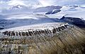
British Empire Range, in the north of Tanquary Fiord
|
|
| Highest point | |
| Peak | Barbeau Peak |
| Elevation | 2,616 m (8,583 ft) |
| Geography | |

Innuitian Mountains
Location in Canada
|
|
| Country | Canada |
| Parent range | Arctic Cordillera |
| Geology | |
| Orogeny | Innuitian |
| Age of rock | Mesozoic |
| Type of rock | Igneous, Metamorphic and Sedimentary |
The Innuitian Mountains are a huge mountain range found in Canada's far north. They stretch across Nunavut and the Northwest Territories. These mountains are part of a larger system called the Arctic Cordillera.
Because of the very cold climate, much of this area remains unexplored. The mountains get their name from the Inuit people, who are the native people of the Arctic.
The Innuitian Mountains can reach heights of over 2,500 m (8,202 ft) (about 8,200 feet). They are also very long, stretching for about 1,290 km (802 mi) (about 800 miles). The very highest point is Barbeau Peak on Ellesmere Island, which stands at 2,616 m (8,583 ft) (about 8,580 feet) tall.
You won't find many trees or much wildlife here. This is because the climate is very harsh and cold. The mountains are located north of the Arctic tree line, which means it's too cold for trees to grow. Most of the land is barren, with large areas of permafrost. Permafrost is ground that stays frozen all year round.
Even though it's a tough place to live, the Innuitian Mountains have valuable mineral resources. These include metals like iron and zinc. There are also fossil fuels such as coal.
The Innuitian Mountains are made up of many smaller mountain ranges. Some of the well-known ones are the British Empire Range, the Princess Margaret Range, and the United States Range. The United States Range is the second most northerly mountain range in the world, after the Challenger Mountains.
European explorers first saw the Innuitian Mountains in 1882. The explorer Adolphus Greely spotted them from Lake Hazen.
How the Innuitian Mountains Formed

The way the Innuitian Mountains look today was shaped a long time ago. This happened during an event called the Innuitian orogeny. An orogeny is a process that creates mountains. This particular mountain-building event took place in the middle of the Mesozoic Era. During this time, the North American Plate (a huge piece of Earth's crust) slowly moved northward. This movement caused the land to fold and push upwards, forming the mountains.
The Innuitian Mountains are mostly made of sedimentary rock. This type of rock forms from layers of sand, mud, and other materials that get pressed together over millions of years. You can also find some igneous rock (formed from cooled lava or magma) and metamorphic rock (rock changed by heat and pressure) here.
These mountains are younger than the Appalachian Mountains in eastern North America. Because they are younger, erosion (the wearing away of rock by wind and water) hasn't had as much time to smooth them down. This is why they still look quite rugged and sharp.
Minerals and Resources
The Innuitian Mountains are similar to the Appalachian Mountains in the types of minerals they contain. However, these mineral resources haven't been used much. It's very expensive to develop mines in such a remote and cold region. It's often cheaper to get these resources from other places in the world.
Even so, the Arctic Region is thought to hold a lot of valuable resources. Experts believe it has about 13% of the world's total oil and 30% of the world's natural gas reserves.
See also
Images for kids
-
British Empire Range, in the north of Tanquary Fiord
-
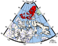
Innuitian Region (in red)
