Islandia, Florida facts for kids
Quick facts for kids
Islandia, Florida
|
|
|---|---|

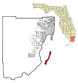
Location in Miami-Dade County and the state of Florida
|
|

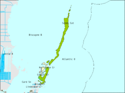
U.S. Census Bureau map showing limits of former city
|
|
| Country | |
| State | |
| County | Miami-Dade |
| Area | |
| • Total | 66.4 sq mi (171.9 km2) |
| • Land | 6.5 sq mi (16.7 km2) |
| • Water | 59.9 sq mi (155.2 km2) |
| Elevation | 3 ft (1 m) |
| Population
(2010)
|
|
| • Total | 18 |
| • Density | 0.271/sq mi (0.1047/km2) |
| Time zone | UTC-5 (Eastern (EST)) |
| • Summer (DST) | UTC-4 (EDT) |
| FIPS code | 12-34175 |
| GNIS feature ID | 0304638 |
Islandia was a small city in Miami-Dade County, Florida, United States. It is now called an unincorporated community, which means it's a place managed by the county, not its own city government. Islandia was located on islands in the upper Florida Keys, like Elliott Key and Totten Key. It was special because it was the only city in the Florida Keys that wasn't in Monroe County.
In 2010, only 18 people lived there. Most of the people who lived there worked for the National Park Service. In 2010, the local government (Miami-Dade County Commission) got the power to close down Islandia as a city. This happened through a special change to their rules called a "charter amendment." On December 6, 2011, the county leaders voted to officially end Islandia as a city. After another public meeting, this decision was made final on March 6, 2012. Islandia officially stopped being a city on March 16, 2012.
Contents
History of Islandia
Early Inhabitants and Settlers
Long ago, the Native American Tequesta people fished around Islandia, especially near Elliott Key. Later, the islands became a safe place for people who survived shipwrecks. By the mid-1800s, some people from The Bahamas moved to Elliott Key. They tried to farm there, but it was hard because the island's ground was made of coral rock.
Growth and Decline
In the early 1900s, Islandia had its own school district and more than 100 residents. However, the number of people living there slowly went down. This was because there was no electricity, farming was difficult, and the islands were far from the mainland.
Plans for a Highway
In 1950, the Dade County Planning Board had a plan to build a highway. This highway would connect Key Biscayne to the Overseas Highway on Key Largo. The idea was to build bridges between artificial islands and existing small keys, leading to Elliott Key and then to Key Largo. But the planning board couldn't get permission to build the highway across Key Biscayne, so they stopped the plan.
Becoming a City and a Big Idea
At the end of 1960, 13 out of the 18 people living on the island voted to make it a city. This is how Islandia was officially formed, including 33 islands in the northern Florida Keys. Developers and residents wanted to bring back the highway plan. They also hoped to build fancy hotels, golf courses, and homes on Elliott Key. They even planned a six-lane road down the middle of the key.
Protecting the Islands
However, many people, like fishermen, gardeners, and state leaders, were against this plan. They wanted to protect the islands by making them part of the national park system. Islandia's mayor, Luther Brooks, and his small city council fought back. At one point, they used a large bulldozer to clear a 125-foot (38 m) wide path down Elliott Key. This was meant to be the start of their big six-lane road, called "Elliott Key Boulevard."
The End of the City
Despite these efforts, the U.S. government bought most of the land on Elliott Key. This stopped all the development plans. In 1968, Islandia became part of Biscayne National Monument, which later became Biscayne National Park. Today, the wide path cleared for the highway is an 8-foot (2.4 m) wide nature trail. People jokingly call it "Spite Highway."
By 1990, the state of Florida was frustrated because Islandia hadn't followed city rules for decades. The state decided that all of Islandia's elections were illegal. This was because only landowners, not all residents, had been allowed to vote, which broke voting-rights laws. The state then called for the city to be closed down. In December 2011, the Miami-Dade County Commission finally agreed. Islandia officially stopped being a city in March 2012. It became an unincorporated area again.
Geography
Islandia is located at 25°23′18″N 80°14′10″W / 25.38833°N 80.23611°W.
The city had a total area of 66.4 square miles (171.9 km2). Out of this, 6.4 square miles (16.7 km2) was land, and 59.9 square miles (155.2 km2) was water. This means about 90% of Islandia's area was water.
Surrounding Areas
Demographics
Population in 2010
In 2010, there were 18 people living in Islandia, making up 3 households. These households included 3 families. The population density was about 2.7 people per square mile (1.0 people per km2). There were 3 housing units in total.
All of the residents (100%) were White. Most of the population (88.9%) were of Hispanic or Latino background. This included people from El Salvador (44.4%), Guatemala (38.9%), and Peru (5.6%).
Out of the 3 households, 2 had children under 18 living with them. All 3 households had a female head of household with no husband present. The average household had 6 people, and the average family had 5.33 people.
The ages of the residents varied:
- 6 people were under 18 years old.
- 8 people were between 25 and 44 years old.
- 3 people were between 45 and 64 years old.
- 1 person was 65 years or older.
The average age was 31.5 years.
The median household income was $47,214. The average income per person was $32,064. No one in Islandia was living below the poverty line.
Population in 2000
In 2000, there were 6 people living in Islandia, making up 3 households and 1 family. The population density was about 0.9 people per square mile (0.3 people per km2). There were 5 housing units. All residents (100%) were White.
Out of the 3 households, one had children under 18. One household was a married couple, and two were non-families. Two households were made up of individuals living alone. The average household had 2 people, and the average family had 4 people.
The ages of the residents were:
- 2 people were under 18 years old.
- 2 people were between 25 and 44 years old.
- 2 people were between 45 and 64 years old.
The average age was 32 years.
The median household income was $41,875, and the median family income was $80,488. The average income per person was $27,000. No one in Islandia was living below the poverty line.
See also
 In Spanish: Islandia (Florida) para niños

