List of communities in Miami-Dade County, Florida facts for kids
Miami-Dade County is a big area in Florida. It has many different communities where people live. These communities are mostly in the eastern part of the county. They include 34 official cities, towns, and villages. There are also 37 special areas called census-designated places. Plus, there are other communities that are not officially part of any city. The main city and government center is Miami. It is also the biggest city with the most people.
Contents
Cities, Towns, and Villages in Miami-Dade
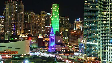
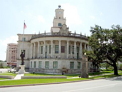

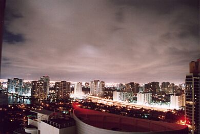
Miami-Dade County has different types of official communities. These are called municipalities. There are nineteen cities, six towns, and nine villages. Even though they have different names, like "city" or "town," they often have similar ways of being governed.
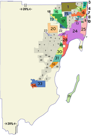
The numbers in the table below match the map you see. The population numbers come from the 2020 US Census. For communities with 5,000 or more residents, we use QuickFacts. For smaller places, we use the US Decennial Census.
| # | Community Name | Type | Date it became official | Number of people |
|---|---|---|---|---|
| 1 | Miami Gardens | City | May 13, 2003 | 111,640 |
| 2 | Aventura | City | November 7, 1995 | 40,242 |
| 3 | Golden Beach | Town | 1929 | 961 |
| 4 | Sunny Isles Beach | City | 1997 | 22,342 |
| 5 | North Miami Beach | City | 1927 | 43,676 |
| 6 | North Miami | City | May 27, 1953 | 60,191 |
| 7 | Bal Harbour | Village | June 16, 1947 | 3,093 |
| 8 | Bay Harbor Islands | Town | April 1947 | 5,922 |
| 9 | Indian Creek | Village | 1939 | 84 |
| 10 | Surfside | Town | May 18, 1935 | 5,689 |
| 11 | Biscayne Park | Village | 1933 | 3,117 |
| 12 | Miami Shores | Village | January 2, 1932 | 11,567 |
| 13 | El Portal | Village | December 7, 1937 | 1,986 |
| 14 | North Bay Village | City | 1945 | 8,159 |
| 15 | Opa-locka | City | 1926 | 16,463 |
| 16 | Miami Lakes | Town | December 5, 2000 | 30,467 |
| 17 | Hialeah | City | 1925 | 223,109 |
| 18 | Hialeah Gardens | City | December 1948 | 23,068 |
| 19 | Medley | Town | 1949 | 1,056 |
| 20 | Doral | City | June 24, 2003 | 75,874 |
| 21 | Miami Springs | City | 1926 | 13,859 |
| 22 | Virginia Gardens | Village | July 10, 1947 | 2,364 |
| 23 | Sweetwater | City | 1941 | 19,363 |
| 24 | Miami | City | July 28, 1896 | 442,241 |
| 25 | Miami Beach | City | March 26, 1915 | 82,890 |
| 26 | Key Biscayne | Village | 1991 | 14,809 |
| 27 | West Miami | City | 1947 | 7,233 |
| 28 | Coral Gables | City | 1925 | 49,248 |
| 29 | South Miami | City | June 24, 1927 | 12,026 |
| 30 | Pinecrest | Village | March 12, 1996 | 18,388 |
| 31 | Palmetto Bay | Village | September 10, 2002 | 24,439 |
| 32 | Cutler Bay | Town | November 9, 2005 | 45,425 |
| 33 | Homestead | City | 1913 | 80,737 |
| 34 | Florida City | City | 1914 | 13,085 |
There was once a city called Islandia. It is shown as #35 on the map. It became a city in 1960 and had only 18 people in 2010. But it stopped being a city in 2012. Now it is just an unincorporated area.
Special Areas: Census-Designated Places
A census-designated place (CDP) is a special area that is not an official city or town. However, the US Census Bureau counts the people living there. This helps them gather information about populations. As of the 2020 United States Census, Miami-Dade County has 37 CDPs. The letters in the table below match the map.
| # | Special Area Name | Number of people |
|---|---|---|
| a | Ives Estates | 25,005 |
| b | Ojus | 19,673 |
| c | Golden Glades | 32,499 |
| d | Country Club | 49,967 |
| e | Palm Springs North | 5,030 |
| f | Pinewood | 17,246 |
| g | Westview | 9,923 |
| h | West Little River | 34,128 |
| i | Gladeview | 14,927 |
| j | Brownsville | 16,583 |
| k | Fountainebleau | 59,870 |
| l | Tamiami | 54,212 |
| m | University Park | 45,284 |
| n | Westchester | 56,384 |
| o | Coral Terrace | 23,142 |
| p | Fisher Island | 561 |
| q | Glenvar Heights | 20,786 |
| r | Olympia Heights | 12,873 |
| s | Westwood Lakes | 11,373 |
| t | Sunset | 15,912 |
| u | Kendall | 80,241 |
| v | Kendale Lakes | 55,646 |
| w | Kendall West | 36,536 |
| x | The Hammocks | 59,480 |
| y | The Crossings | 23,276 |
| z | Palmetto Estates | 13,498 |
| aa | Richmond Heights | 8,944 |
| bb | Three Lakes | 16,540 |
| cc | Country Walk | 16,951 |
| dd | Richmond West | 35,884 |
| ee | West Perrine | 10,602 |
| ff | South Miami Heights | 36,770 |
| hh | Goulds | 11,446 |
| ii | Princeton | 39,308 |
| jj | Naranja | 13,509 |
| kk | Leisure City | 26,324 |
| ll | Homestead Base | 999 |
The special area called Lakes by the Bay (gg on the map) is now part of the Town of Cutler Bay.
Other Communities Without Official Borders
Some areas in Miami-Dade County are called "unincorporated communities." This means they are not part of any official city, town, or village. Their borders are not always clear and can sometimes overlap with other areas.
These communities can be very different from each other. For example, Frog City is like a ghost town with very few people. But Little Gables is a busy suburban area. Redland is more rural but still has many residents.
- Coopertown
- Frog City
- Islandia
- Little Gables
- High Pines
- Pennsuco
- Peters
- Ponce-Davis
- Redland
- Silver Palm
- West End
- West Kendall
Neighborhoods Inside Cities
Many cities have smaller parts within them called neighborhoods or districts. These are areas that have their own unique feel or history. Here are some examples of neighborhoods and the cities they belong to:
See also
- C-9 Basin
- Miami metropolitan area
- Category:Cities in Miami-Dade County, Florida
- Category:Villages in Miami-Dade County, Florida
- Category:Towns in Miami-Dade County, Florida
- Category:Census-designated places in Miami-Dade County, Florida
- Category:Former census-designated places in Miami-Dade County, Florida
- Category:Unincorporated communities in Miami-Dade County, Florida
- Category:Neighborhoods in Miami
- Category:Neighborhoods in Miami-Dade County, Florida
 | Valerie Thomas |
 | Frederick McKinley Jones |
 | George Edward Alcorn Jr. |
 | Thomas Mensah |


