Ojus, Florida facts for kids
Quick facts for kids
Ojus, Florida
|
|
|---|---|

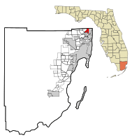
Location in Miami-Dade County and the state of Florida
|
|

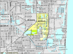
U.S. Census Bureau map showing CDP boundaries
|
|
| Country | |
| State | |
| County | |
| Area | |
| • Total | 3.16 sq mi (8.18 km2) |
| • Land | 2.65 sq mi (6.86 km2) |
| • Water | 0.51 sq mi (1.32 km2) |
| Elevation | 10 ft (3 m) |
| Population
(2020)
|
|
| • Total | 19,673 |
| • Density | 7,426.58/sq mi (2,867.48/km2) |
| Time zone | UTC-5 (Eastern (EST)) |
| • Summer (DST) | UTC-4 (EDT) |
| ZIP codes | |
| Area code(s) | 305, 786, 645 |
| FIPS code | 12-51125 |
| GNIS feature ID | 0288066 |
Ojus is a community in Miami-Dade County, Florida, in the United States. It's not an official city, but a "census-designated place" (CDP). This means it's an area that the government counts for population, but it doesn't have its own city government. Ojus is part of the larger Miami metropolitan area in South Florida. In 2020, about 19,673 people lived there.
Contents
History of Ojus
People have lived in the Ojus area for a very long time. Scientists have found signs of Paleo-Indians living in South Florida over 13,000 years ago. Ancient sites have also been found near Arch Creek and along the Oleta River.
Early Native American Life
The Tequesta people were a major Native American group in this area. While their main settlement was by the Miami River, about 100 Tequesta people lived in the Ojus area around 750 BCE. The Oleta River, which flows through Ojus, was like a main road for the Tequesta for thousands of years. Later, groups like the Seminoles and early European explorers also used this river.
Naming Ojus
In the late 1800s, settlers started farms along the Oleta River. They grew crops like peas, beans, and tomatoes. The Seminole people even set up a trading post near what is now Greynolds Park to trade with these settlers. In 1897, a man named Albert Fitch named the area "Ojus." This name comes from a Seminole word that means "plenty" or "lots of."
Growth and Development
After 1900, people discovered that the area had a lot of rock perfect for building roads. Many of the lakes you see in Ojus today were created when people dug out this rock to help build roads and other important structures.
For a while, Ojus tried to become an official town. Voters approved it several times in the 1920s and 1930s. However, due to problems with boundaries and debts, the town government was eventually dissolved in 1935.
Important Landmarks
Two important landmarks were created in the early 1900s. In 1925, a wooden race track called the Fulford–Miami Speedway was built. It was known as the world's fastest track but was sadly destroyed by a big hurricane in 1926.
One of the most famous places in the region, Greynolds Park, was created in 1936. This happened as part of President Franklin Roosevelt's "New Deal" programs, specifically the Civilian Conservation Corps (CCC). The park was named after Mr. A.O. Greynolds, who owned the Ojus Rock Company. He donated a large piece of his land for the park. Over time, the park grew to include a golf course and even hosted famous music groups like the Grateful Dead in the 1960s. Greynolds Park was recognized as a historic site in 1983.
More recently, in 2006, the Ojus Urban Area District (OUAD) was created. This group helps plan for the future of the Ojus area. In 2018, there was a vote to form a new city from parts of Ojus and nearby communities, but it did not pass.
Geography of Ojus
Ojus is located in the northeastern part of Miami-Dade County, Florida. It is about 15 miles (24 km) north-northeast of downtown Miami. The northern edge of Ojus touches the border of Broward County.
Borders and Nearby Communities
Within Miami-Dade County, Ojus is next to Aventura to the east, North Miami Beach to the south, and Ives Estates to the west. In Broward County, its neighbors are Pembroke Park to the northwest and Hallandale Beach to the north.
Major roads near Ojus include Interstate 95, which forms its western border. You can get to Ojus from I-95 using Exit 16 (Ives Dairy Road). U.S. Route 1 (Biscayne Boulevard) runs close to Ojus's eastern border.
Land and Water
Ojus covers a total area of about 3.16 square miles (8.18 square kilometers). Most of this is land (2.65 square miles or 6.86 square kilometers), and about 0.51 square miles (1.32 square kilometers) is water. The Oleta River flows through the eastern part of the community. The land in Ojus is mostly flat, ranging from 0 to 12 feet (0 to 3.7 meters) above sea level.
Ojus is in the Eastern Standard Time Zone.
Surrounding areas
Population and People
The number of people living in Ojus has changed over the years. Here's how the population has grown:
| Historical population | |||
|---|---|---|---|
| Census | Pop. | %± | |
| 1980 | 17,344 | — | |
| 1990 | 15,519 | −10.5% | |
| 2000 | 16,642 | 7.2% | |
| 2010 | 18,036 | 8.4% | |
| 2020 | 19,673 | 9.1% | |
| U.S. Decennial Census | |||
2020 Census Information
The 2020 United States census counted 19,673 people living in Ojus. There were 6,690 households and 4,257 families.
The table below shows the different racial and ethnic groups in Ojus based on the 2010 and 2020 censuses. It's important to know that the U.S. Census counts Hispanic/Latino as an ethnic group, and people of any race can be Hispanic/Latino.
| Race / Ethnicity (NH = Non-Hispanic) | Pop 2010 | Pop 2020 | % 2010 | % 2020 |
|---|---|---|---|---|
| White (NH) | 7,772 | 6,737 | 43.09% | 34.24% |
| Black or African American (NH) | 1,611 | 1,544 | 8.93% | 7.85% |
| Native American or Alaska Native (NH) | 4 | 9 | 0.02% | 0.05% |
| Asian (NH) | 364 | 397 | 2.02% | 2.02% |
| Pacific Islander or Native Hawaiian (NH) | 6 | 0 | 0.05% | 0.00% |
| Some other race (NH) | 76 | 172 | 0.42% | 0.87% |
| Mixed race or Multiracial (NH) | 221 | 630 | 1.23% | 3.20% |
| Hispanic or Latino (any race) | 7,979 | 10,184 | 44.24% | 51.77% |
| Total | 18,036 | 19,673 | 100.00% | 100.00% |
Education in Ojus
Public schools in Ojus are run by Miami-Dade County Public Schools.
- Ojus Elementary School is located in Ojus.
- Students living in Ojus usually attend Krop High School.
There are also private schools in the area:
- St. Lawrence K-8 School is a Catholic school operated by the Roman Catholic Archdiocese of Miami.
- Samuel Scheck Hillel Community Day School is also located in Ojus.
See also
 In Spanish: Ojus (Florida) para niños
 | Jackie Robinson |
 | Jack Johnson |
 | Althea Gibson |
 | Arthur Ashe |
 | Muhammad Ali |

