Ives Estates, Florida facts for kids
Quick facts for kids
Ives Estates, Florida
|
|
|---|---|

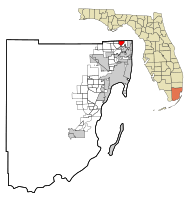
Location in Miami-Dade County and the state of Florida
|
|

U.S. Census Bureau map showing CDP boundaries
|
|
| Country | |
| State | |
| County | |
| Area | |
| • Total | 2.76 sq mi (7.15 km2) |
| • Land | 2.55 sq mi (6.60 km2) |
| • Water | 0.21 sq mi (0.55 km2) |
| Elevation | 10 ft (3 m) |
| Population
(2020)
|
|
| • Total | 25,005 |
| • Density | 9,813.58/sq mi (3,788.69/km2) |
| Time zone | UTC-5 (Eastern (EST)) |
| • Summer (DST) | UTC-4 (EDT) |
| ZIP Code |
33179 (Miami)
|
| Area code(s) | 305, 786, 645 |
| FIPS code | 12-34400 |
| GNIS feature ID | 0284640 |
Ives Estates is a community in Miami-Dade County, Florida. It is called a census-designated place (CDP) because it's an area that the U.S. Census Bureau defines for gathering population data. It's part of the larger Miami metropolitan area in South Florida. In 2020, about 25,005 people lived there. This was an increase from 19,525 people in 2010.
Contents
Where is Ives Estates?
Ives Estates is located in the northeastern part of Miami-Dade County, Florida. It sits right next to Broward County to the north. Some of its neighbors include Ojus to the east and North Miami Beach to the south. Miami Gardens is to the west.
Getting Around Ives Estates
Interstate 95 runs along the border of Ives Estates. This major highway makes it easy to travel to nearby cities. Downtown Miami is about 16 miles (26 km) to the south. Fort Lauderdale is about 11 miles (18 km) to the north. The main road through Ives Estates is Ives Dairy Road. This road connects the community to places like Aventura in the east and Miami Gardens in the west.
Size of Ives Estates
Ives Estates covers a total area of about 2.76 square miles (7.15 square kilometers). Most of this area, about 2.55 square miles (6.60 square kilometers), is land. The rest, about 0.21 square miles (0.55 square kilometers), is water.
Who Lives in Ives Estates?
The population of Ives Estates has grown over the years. Here's how the number of people living there has changed:
| Historical population | |||
|---|---|---|---|
| Census | Pop. | %± | |
| 1980 | 12,623 | — | |
| 1990 | 13,531 | 7.2% | |
| 2000 | 17,586 | 30.0% | |
| 2010 | 19,525 | 11.0% | |
| 2020 | 25,005 | 28.1% | |
| U.S. Decennial Census 1990 2000 |
|||
People and Backgrounds in 2020
In 2020, there were 25,005 people living in Ives Estates. These people lived in about 8,391 households. A household is a group of people living together in one home. About 5,516 of these households were families.
The community is home to people from many different backgrounds. The U.S. Census keeps track of different racial and ethnic groups.
| Race / Ethnicity (NH = Non-Hispanic) | Pop 2000 | Pop 2010 | Pop 2020 | % 2000 | % 2010 | % 2020 |
|---|---|---|---|---|---|---|
| White (NH) | 5,863 | 3,639 | 3,602 | 33.34% | 18.64% | 14.41% |
| Black or African American (NH) | 5,957 | 9,348 | 10,733 | 33.87% | 47.88% | 42.92% |
| Native American or Alaska Native (NH) | 22 | 30 | 28 | 0.13% | 0.15% | 0.11% |
| Asian (NH) | 794 | 569 | 627 | 4.51% | 2.91% | 2.51% |
| Pacific Islander or Native Hawaiian (NH) | 9 | 6 | 12 | 0.05% | 0.03% | 0.05% |
| Some other race (NH) | 87 | 113 | 312 | 0.49% | 0.58% | 1.25% |
| Mixed race or Multiracial (NH) | 620 | 418 | 905 | 3.53% | 2.14% | 3.62% |
| Hispanic or Latino (any race) | 4,234 | 5,402 | 8,786 | 24.08% | 27.67% | 35.14% |
| Total | 17,586 | 19,525 | 25,005 | 100.00% | 100.00% | 100.00% |
Schools in Ives Estates
Students in Ives Estates attend public schools managed by Miami-Dade County Public Schools.
- Madie Ives K-8 Preparatory Academy
- Dr. Michael M. Krop High School
See also
 In Spanish: Ives Estates para niños
 | DeHart Hubbard |
 | Wilma Rudolph |
 | Jesse Owens |
 | Jackie Joyner-Kersee |
 | Major Taylor |

