
Ittigen facts for kids
Quick facts for kids
Ittigen
|
||
|---|---|---|
 |
||
|
||

Ittigen
Location in Switzerland

Ittigen
Location in Canton of Bern
|
||
| Country | Switzerland | |
| Canton | Bern | |
| District | Bern-Mittelland | |
| Area | ||
| • Total | 4.2 km2 (1.6 sq mi) | |
| Elevation | 526 m (1,726 ft) | |
| Population
(Dec 2020 )
|
||
| • Total | 11,430 | |
| • Density | 2,720/km2 (7,050/sq mi) | |
| Postal code |
3063
|
|
| Surrounded by | Bern, Bolligen, Moosseedorf, Münchenbuchsee, Ostermundigen, Zollikofen | |
| Twin towns | Dobrush (Belarus) | |

Ittigen is a town in Switzerland. It is located in the Canton of Bern, which is a large region in Switzerland. Ittigen is part of the Bern-Mittelland administrative district.
Ittigen became its own town in 1983. Before that, it was part of a larger area called Bolligen. Another town, Ostermundigen, also became separate from Bolligen at the same time.
Contents
History of Ittigen
The name Ittigen comes from an old German phrase meaning "at the people of Ito." It was first written down in 1318 as Yttigen. Later, in 1326, it was called villa de Ittigen.
Early Settlements and Discoveries
People have lived in this area for a very long time! Scientists have found signs of ancient settlements. For example, at a place called Worblaufen, they found a special pot from the La Tene culture (an ancient Iron Age culture). This pot contained ashes from a cremation. They also found old Roman coins and graves from the Early Middle Ages.
In another area called Papiermühle, an Early Medieval cemetery with about 30 graves was discovered. More old graves were found in Neuhaus, and a type of knife called a Seax was found in Wydacker.
How Villages Grew
Small villages like Papiermühle, Schermen, Neuhaus, and Badhaus grew up in the valley. At the same time, farming villages like Ittigen and Worblaufen developed on higher ground. These farming villages had lots of land for growing crops. They also shared common land and forests.
The villages in the mountains mostly focused on farming. But the villages in the valley became places for trade and businesses.
- A paper mill opened in Papiermühle in 1466. There was also a toll house (where people paid to use a road) and an inn (a place to stay).
- Schermen had a mill.
- Neuhaus also had a toll house and an inn.
- Badhaus had a spa and an inn from the 1400s.
- Worblaufen later got a paper mill and several hammer mills (which used hammers to shape metal).
Around the 17th and 18th centuries, the farming villages started growing fruits, vegetables, and hay. They sold these at weekly markets in the nearby city of Bern. Because the area was sunny and close to Bern, some rich families built large country homes here. Examples include Mannenberg in Ittigen and Sandhof and Lindenhof in Worblaufen.
In the 1800s, farming was still important. But many people also worked in small workshops or did "cottage industry" work from home. A pasta factory opened in Schermen in 1831, and a chocolate factory followed in 1917.
Becoming Independent
For a long time, Ittigen was part of Bolligen. Even though it was part of Bolligen, Ittigen had some independence. It had its own church group that helped the poor, took care of orphans, and managed education and taxes. However, it still had to follow the rules of Bolligen.
In 1774, Ittigen tried to get its own coat of arms, but it didn't happen then. The village school was started in 1813 and opened in 1818. This school gave Ittigen more independence. In 1834, Ittigen became one of four main parts of Bolligen. These parts were in charge of things like the fire department, roads, and primary schools. The main Bolligen town handled money and higher education.
Throughout the 1900s, people in the area voted many times on whether to join Bern, combine all town services, or split into separate towns. Finally, in 1978, residents voted to become independent towns. Between 1980 and 1983, Ittigen officially took over its own town duties from Bolligen.
Geography of Ittigen
Ittigen covers an area of about 4.20 square kilometers (1.62 square miles).
Land Use
- About 24.5% of the land is used for farming.
- About 14.3% is covered by forests.
- Most of the land, about 60.3%, is settled with buildings or roads.
- A small part, about 1.0%, is rivers or lakes.
Looking closer at the settled areas:
- Industrial buildings make up 5.0%.
- Houses and other buildings make up 33.7%.
- Roads and other transport areas make up 18.5%.
- Parks, green areas, and sports fields make up 1.7%.
The town is located in the Worblental (Worblen valley). It sits on a high area called the Mannenberg, which is about 688 meters (2,257 feet) high. Ittigen is also part of the larger city area around Bern.
Coat of Arms
The coat of arms for Ittigen has a special design. It is divided into four sections, with red and gold colors. In one section, there is a black grenade (a type of bomb) with red flames. In another section, there is a black mill wheel.
People of Ittigen (Demographics)
Ittigen has a population of about 11,500 people.
Population Changes and Languages
Over the last 10 years (2000–2010), the number of people living in Ittigen changed a little, going down by about 2.4%.
Most people in Ittigen (about 86.2%) speak German as their main language. The next most common languages are Italian (2.6%) and French (2.5%).
Who Lives Here?
- About 48.7% of the population are men and 51.3% are women.
- About 15.5% of the people living in Ittigen in 2000 were also born there.
- Many people (43%) were born in the same canton (region) of Bern.
- About 18.5% of the people were born outside of Switzerland.
Age Groups
- Children and teenagers (0–19 years old) make up 18.4% of the population.
- Adults (20–64 years old) make up 62.2%.
- Seniors (over 64 years old) make up 19.4%.
Housing
In 2000, there were about 1,923 homes where only one person lived. There were also 199 homes with five or more people. Most apartments (94.4%) were lived in all the time.
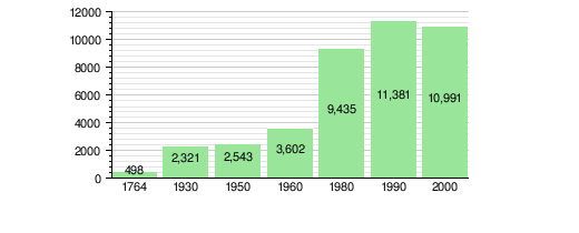
Population Over Time
The chart below shows how Ittigen's population has grown over the years:
Important Heritage Sites

The Gosteli Foundation is a very important place in Ittigen. It has an archive (a collection of historical documents) about the history of the Swiss feminist movement. This foundation is listed as a special heritage site of national significance.
The entire Worbletal (Worble valley), which includes Ittigen and nearby towns like Bolligen, Ostermundigen, and Stettlen, is also recognized as an important Swiss heritage area.
Economy and Jobs
Ittigen has a low unemployment rate, which means most people who want to work can find jobs.
Types of Jobs
In 2008, there were almost 9,000 people working in Ittigen. Jobs are divided into three main types:
- Primary Sector: This includes jobs like farming. In Ittigen, a small number of people (19) work in this sector.
- Secondary Sector: This includes jobs in manufacturing (making things) and construction (building things). About 867 people work in this sector in Ittigen. Many of them (65.9%) work in manufacturing.
- Tertiary Sector: This is the largest sector, with about 8,090 people working here. It includes many different jobs like:
- Sales and repair of cars (10.5%)
- Moving and storing goods (10.3%)
- Working in hotels or restaurants (2.7%)
- Information industry (26.6%)
- Insurance or finance (5.8%)
- Scientists and technical experts (5.0%)
- Education (1.8%)
- Health care (4.5%)
Many people travel into Ittigen for work. In 2000, about 5,490 workers came into Ittigen, and 4,882 workers left Ittigen to work elsewhere. This means more people come to Ittigen for jobs than leave it.
Unique Income Source
Since 1991, Ittigen has had a special way to earn money for its budget: parking fees from a highway rest stop called Grauholz. This is quite unusual and has even been written about in newspapers [1]. The town still gets money from these parking fees today.
Religion in Ittigen
Based on a 2000 survey:
- About 55.2% of the people belonged to the Swiss Reformed Church (a type of Protestant church).
- About 20.7% were Roman Catholic.
- Smaller numbers of people belonged to other Christian churches, Orthodox churches, or the Christian Catholic Church of Switzerland.
- About 3.52% of the population were Muslim.
- There were also people who were Buddhist, Hindu, or followed other religions.
- About 9.94% of the people said they did not belong to any church or were atheist.
Education in Ittigen
Education is very important in Switzerland. In Ittigen, about 42.9% of the people have finished non-mandatory higher education (like high school), and 15.6% have gone on to college or university.
Swiss School System
The school system in the Canton of Bern works like this:
- One year of optional Kindergarten.
- Six years of Primary school.
- Three years of mandatory lower Secondary school. In this stage, students are grouped based on their abilities.
- After lower Secondary, students can choose to continue their education or start an apprenticeship (learning a trade on the job).
Students in Ittigen
During the 2009–2010 school year, 1,474 students attended schools in Ittigen.
- There were 8 kindergarten classes with 168 students.
- There were 28 primary classes with 522 students.
- There were 16 lower secondary classes with 275 students.
Some students who live in Ittigen go to school in other towns, and some students from other towns come to school in Ittigen.
Notable People from Ittigen
- Hans Zulliger (1893–1965 in Ittigen): A child psychoanalyst, author, and primary school teacher in Ittigen for many years.
- Marthe Gosteli (1917 in Worblaufen – 2017): A famous Swiss activist who worked for women's right to vote and an archivist.
- Jürg M. Stauffer (born 1977): A Swiss politician from Ittigen.
- Marc Hirschi (born 1998): A professional cyclist from Switzerland.
- Daniel Bernhardt (born 1965): A Swiss actor, model, and martial artist.
See also
 In Spanish: Ittigen para niños
