Kendall, Florida facts for kids
Quick facts for kids
Kendall, Florida
|
|
|---|---|

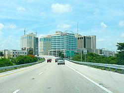
Dadeland forms the business area of Kendall.
|
|

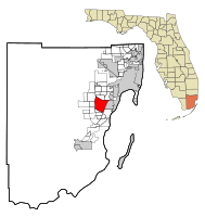
Location in Miami-Dade County and the state of Florida
|
|

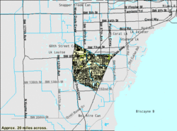
U.S. Census Bureau map of Kendall showing boundaries
|
|
| Country | |
| State | |
| County | |
| Area | |
| • Total | 16.60 sq mi (43.00 km2) |
| • Land | 16.10 sq mi (41.70 km2) |
| • Water | 0.50 sq mi (1.30 km2) |
| Elevation | 13 ft (4 m) |
| Population
(2020)
|
|
| • Total | 80,241 |
| • Density | 4,984.22/sq mi (1,924.42/km2) |
| Time zone | UTC−5 (Eastern (EST)) |
| • Summer (DST) | UTC−4 (EDT) |
| ZIP Codes |
33156, 33173, 33176, 33183, 33186 (Miami)
|
| Area code(s) | 305, 786, 645 |
| FIPS code | 12-36100 |
| GNIS feature ID | 0285050 |
Kendall is a community in Miami-Dade County, Florida, United States. It is not an official city but is a "census-designated place," meaning it's an area recognized by the U.S. Census Bureau. Kendall is part of the larger Miami metropolitan area. In 2020, about 80,241 people lived there.
Contents
- History of Kendall: How the Area Grew
- Geography: Where is Kendall Located?
- Climate: What's the Weather Like in Kendall?
- Demographics: Who Lives in Kendall?
- Transportation: Getting Around Kendall
- Economy: Businesses and Shopping in Kendall
- Notable People from Kendall
- Education: Schools and Colleges in Kendall
- Media: News and Entertainment in Kendall
- See also
History of Kendall: How the Area Grew
Much of the land that is now Kendall was bought in 1883 by a company called the Florida Land and Mortgage Company. The area was named after Henry John Broughton Kendall, a director of this company. He moved to the area in the early 1900s to manage the company's land.
Because the land was not available for "homesteading" (meaning people couldn't just claim and settle on it for free), the area grew slowly. A post office opened in 1914, and the first school started in 1929. After a period of fast growth in Florida ended around 1926, some people left the area. Native American Seminole camps were also in the Kendall area, and Seminoles lived there until the 1940s.
How the Name "Kendall" Changed Over Time
Before the 1950s, "Kendall" referred to a specific area around U.S. Route 1. This area was mostly empty, with pine forests and some farms. As the region developed quickly in the 1950s, the name "Kendall" began to include new communities built nearby.
Later, in the 1970s, 1980s, and 1990s, growth moved further west. Because of this, the name "Kendall" also started to refer more to the western parts of the area, now often called West Kendall.

In August 1992, a very strong storm called Hurricane Andrew caused a lot of damage to Kendall and the surrounding areas. Many homes and businesses were destroyed. Over the next few years, the community worked hard to rebuild.
Geography: Where is Kendall Located?
Kendall is located about 14 miles (23 km) southwest of downtown Miami. It is surrounded by several other communities. To the east is Pinecrest, and to the southeast is Palmetto Bay.
Important roads like U.S. Route 1 form Kendall's eastern border. This road goes northeast to Miami and southwest to Homestead. The Homestead Extension of Florida's Turnpike is on Kendall's western side. This highway goes north to Doral and south to Florida City. The Don Shula Expressway (Florida State Road 874) also crosses Kendall.
The Kendall area covers about 16.6 square miles (43.0 km2). Most of this area, about 16.1 square miles (41.7 km2), is land. The remaining 0.5 square miles (1.3 km2) is water.
Climate: What's the Weather Like in Kendall?
Kendall has a tropical monsoon climate. This means it has warm temperatures all year round and a wet season with lots of rain. It's similar to the rest of Miami-Dade County. However, because Kendall is inland and not right on the coast, it can be a bit cooler at night and warmer during the day compared to places like Miami Beach.
| Climate data for Kendall, Florida (Miami Executive Airport), 1991–2020 normals, extremes 1998–present | |||||||||||||
|---|---|---|---|---|---|---|---|---|---|---|---|---|---|
| Month | Jan | Feb | Mar | Apr | May | Jun | Jul | Aug | Sep | Oct | Nov | Dec | Year |
| Record high °F (°C) | 88 (31) |
91 (33) |
92 (33) |
97 (36) |
97 (36) |
98 (37) |
99 (37) |
99 (37) |
95 (35) |
96 (36) |
92 (33) |
89 (32) |
99 (37) |
| Mean maximum °F (°C) | 84.9 (29.4) |
87.3 (30.7) |
90.0 (32.2) |
92.2 (33.4) |
94.4 (34.7) |
95.2 (35.1) |
94.9 (34.9) |
95.7 (35.4) |
93.9 (34.4) |
92.1 (33.4) |
87.5 (30.8) |
85.2 (29.6) |
96.7 (35.9) |
| Mean daily maximum °F (°C) | 76.9 (24.9) |
79.6 (26.4) |
81.9 (27.7) |
85.1 (29.5) |
88.2 (31.2) |
90.3 (32.4) |
91.2 (32.9) |
91.7 (33.2) |
89.8 (32.1) |
87.0 (30.6) |
81.9 (27.7) |
78.8 (26.0) |
85.2 (29.6) |
| Daily mean °F (°C) | 66.9 (19.4) |
69.1 (20.6) |
71.5 (21.9) |
75.0 (23.9) |
78.9 (26.1) |
82.1 (27.8) |
83.1 (28.4) |
83.6 (28.7) |
82.3 (27.9) |
79.2 (26.2) |
73.1 (22.8) |
69.4 (20.8) |
76.2 (24.6) |
| Mean daily minimum °F (°C) | 56.8 (13.8) |
58.6 (14.8) |
61.1 (16.2) |
64.9 (18.3) |
69.5 (20.8) |
74.0 (23.3) |
74.9 (23.8) |
75.4 (24.1) |
74.7 (23.7) |
71.3 (21.8) |
64.3 (17.9) |
60.0 (15.6) |
67.1 (19.5) |
| Mean minimum °F (°C) | 40.0 (4.4) |
44.6 (7.0) |
47.1 (8.4) |
54.4 (12.4) |
61.7 (16.5) |
69.9 (21.1) |
71.5 (21.9) |
72.5 (22.5) |
70.6 (21.4) |
62.3 (16.8) |
51.4 (10.8) |
46.8 (8.2) |
37.4 (3.0) |
| Record low °F (°C) | 30 (−1) |
32 (0) |
35 (2) |
44 (7) |
53 (12) |
66 (19) |
68 (20) |
69 (21) |
67 (19) |
52 (11) |
38 (3) |
31 (−1) |
30 (−1) |
| Average precipitation inches (mm) | 1.74 (44) |
1.96 (50) |
2.03 (52) |
2.86 (73) |
5.16 (131) |
8.82 (224) |
7.19 (183) |
8.28 (210) |
8.42 (214) |
5.25 (133) |
2.09 (53) |
2.28 (58) |
56.08 (1,424) |
| Average precipitation days (≥ 0.01 in) | 9.4 | 8.0 | 7.3 | 7.4 | 11.2 | 18.7 | 18.9 | 18.1 | 18.0 | 12.6 | 8.9 | 10.1 | 148.6 |
| Source: NOAA (mean maxima/minima 2006–2020) | |||||||||||||
Demographics: Who Lives in Kendall?
| Historical population | |||
|---|---|---|---|
| Census | Pop. | %± | |
| 1970 | 35,497 | — | |
| 1980 | 73,758 | 107.8% | |
| 1990 | 87,271 | 18.3% | |
| 2000 | 75,226 | −13.8% | |
| 2010 | 75,371 | 0.2% | |
| 2020 | 80,241 | 6.5% | |
| source: | |||
Population Changes in Kendall
| Race / Ethnicity (NH = Non-Hispanic) | Pop 2010 | Pop 2020 | % 2010 | % 2020 |
|---|---|---|---|---|
| White (NH) | 21,432 | 16,781 | 28.44% | 20.91% |
| Black or African American (NH) | 2,680 | 2,339 | 3.56% | 2.91% |
| Native American or Alaska Native (NH) | 37 | 31 | 0.05% | 0.04% |
| Asian (NH) | 2,190 | 2,087 | 2.91% | 2.60% |
| Pacific Islander or Native Hawaiian (NH) | 24 | 13 | 0.03% | 0.02% |
| Some other race (NH) | 232 | 369 | 0.31% | 0.46% |
| Mixed race or Multiracial (NH) | 738 | 1,558 | 0.98% | 1.94% |
| Hispanic or Latino (any race) | 48,038 | 57,063 | 63.74% | 71.11% |
| Total | 75,371 | 80,241 | 100.00% | 100.00% |
In 2020, there were 80,241 people living in Kendall. These people made up 27,691 households, and 19,077 of those were families. In 2010, there were 75,371 people, 27,287 households, and 18,812 families.
Transportation: Getting Around Kendall
Kendall has public transportation options to help people get around. The Metrobus system serves the entire area. There are also two Metrorail stations:
- Dadeland North (located at SW 70th Avenue and U.S. 1)
- Dadeland South (located at Dadeland Boulevard and U.S. 1)
These Metrorail stations offer train service from Dadeland to important places like Coral Gables, Downtown Miami, and Miami International Airport. Dadeland South station is a big transportation hub. From there, you can connect to bus routes that go to the southernmost cities of Homestead and Florida City.
Economy: Businesses and Shopping in Kendall
Pollo Tropical, a popular restaurant chain, has its main office (headquarters) in Dadeland, which is part of Kendall. They moved their headquarters there in 1994.
Kendall is also home to two large shopping centers. Dadeland Mall is an indoor mall in East Kendall with major department stores like Macy's, Saks Fifth Avenue, and JCPenney. In South Kendall, you'll find The Falls (mall), which is an outdoor shopping mall. It also has a Macy's and a Regal Cinema.
Before it closed down, the airline Air Florida had its main office in the Dade Towers, which is now in the Kendall area.
Notable People from Kendall
- Hank Kaplan, a historian who studied boxing
- Janet Reno, who was the 78th U.S. Attorney General
- O. J. Simpson, a famous American football player
Education: Schools and Colleges in Kendall
Primary, Middle, and Secondary Schools
Public Schools
The first public school in Kendall was Kendall School, which is now called Kenwood K-8 Center. Kenwood is special because it has the Kenwoods Hammock, a natural forest area. This forest has become a famous spot for people who enjoy watching birds.
The public schools in Kendall are managed by Miami-Dade County Public Schools.
Schools for All Grades (K-12)
- Instructional Center System Wide
- Ruth Owen Kruse Education Center
High Schools
- Miami Killian High School
- Miami Palmetto High School (serves some parts of Kendall, located in Pinecrest)
- School for Advanced Studies (Kendall campus)
- Miami Sunset Senior High School
- Felix Varela Senior High School
Middle Schools
- Archimedean Middle Conservatory (a charter school)
- Miami MacArthur South
- Pinecrest Academy (North Campus) (a charter school)
- Hammocks Middle School
- Howard D. McMillan Middle School
- Arvida Middle School
- Miami Arts studio
Elementary Schools
- Academir Charter School West
- Archimedean Academy (a charter school)
- Bowman Foster Ashe Elementary School
- Calusa Elementary School
- Christina M. Eve Elementary School
- Claude Pepper Elementary School
- Dante B. Fascell Elementary School
- Devon Aire K–8 Center
- Dr. Manuel C. Barreiro Elementary School
- Gilbert Porter Elementary School
- Jane S. Roberts K–8 School
- Kendale Elementary
- Kendale Lakes Elementary
- Kenwood Elementary
- Leewood Elementary School
- Oliver Hoover Elementary School
- Santa Fe Advantage Academy (a charter school)
- Sunset Park Elementary School
- Vineland K–8 Center
- Winston Park K–8 Center
- William H. Lehman Elementary
Private Schools
- Atlantis Academy (K–12)
- Calusa Preparatory School
- Cattoira Montessori School (Pre-Kindergarten–5th grade)
- Children's Resources (Pre-Kindergarten–2nd grade)
- Florida Christian School
- Gateway Christian School
- Greenfield Day School (K–8)
- Islamic School of Miami
- Kendall Christian School (Pre-Kindergarten–5th grade)
- Killian Oaks Academy
- La Scuola (Pre-Kindergarten–3rd grade)
- Learning Links Schoolhouse (K–5)
- St. Catherine of Siena Catholic School
- St. John Neuman School (Pre-Kindergarten–8th grade) - Started in 1981.
- Westminster Christian School
- Westwood Christian School
Colleges and Universities
- College of Business and Technology (Kendall Campus)
- Kaplan University (Support Center)
- Keiser University (Kendall Campus)
- Miami-Dade College (Kendall Campus)
- Nova Southeastern University (Miami Student Educational Center)
- Polleo Institute (Higher education)
Supplementary Schools
Miami Hoshuko, which is a weekend school for Japanese citizens, used to hold classes at the Kendall United Methodist Church. This church is now in Pinecrest, but it was part of the Kendall area in 1990.
Media: News and Entertainment in Kendall
Kendall is part of the Miami area for local radio and television stations. Kendall also has its own newspaper called The Kendall Gazette. This newspaper is published twice a month and is part of Miami Community Newspapers.
See also
 In Spanish: Kendall (Florida) para niños

