
Kentish Knock (England) facts for kids
The Kentish Knock is a long, shallow area of sand and gravel in the North Sea. It's located east of Essex, England. This underwater bank is the furthest east of the many shallow areas found in the Thames Estuary. The main part of the Kentish Knock is less than 18 feet (5.5 m) deep and stretches for about 6 miles (9.7 km). Because it is so shallow, it can be dangerous for large ships. It is about 28 miles (45 km) east of Foulness Point in Essex and about 15 miles (24 km) north-northeast of North Foreland in Kent.
Contents
What is the Kentish Knock?
The Kentish Knock is located between two very different areas of the sea. On one side, there's a spot in the southwest North Sea where the tides are very small. On the other side, there's the narrowest part of the English Channel (the Strait of Dover) and the heart of the Tideway, which have very big tides.
The Kentish Knock is one of several sandbanks in this area. These banks usually line up from north-northeast to south-southwest. However, as they get closer to the Thames Estuary, they turn more towards the west. The tides constantly move sand and gravel. This causes the northern part of the Kentish Knock, which is the steepest and narrowest, to point a bit more north-south than its southern part.
Animals and Plants of the Kentish Knock
The Kentish Knock is made of sand and gravel. It is home to many interesting sea creatures. You can find hermit crabs, sand goby fish, rays, and catsharks living here. Sometimes, rare red-throated diver birds visit the area.
Scientists believe that the deep channels around the Kentish Knock were formed by huge floods from melting glaciers thousands of years ago. Since 2012, an organization called The Wildlife Trusts has been working to protect a 96 km2 part of the Knock, known as Kentish Knock East. They want it to become a Marine Conservation Zone. This would help keep its unique wildlife safe.
Mapping the Kentish Knock

Old sea charts used special numbers to show water depth. For example, a depth of 11 meant one fathom (which is six feet) and one extra foot. So, it was 7 feet deep. Some parts of the Kentish Knock used to be marked as "01" at low tide. This meant they were only one foot deep! At such a shallow depth, these areas would become visible above the water during the lowest tides, called spring tides.
History of the Kentish Knock
The Kentish Knock has been important for ships and navigation for hundreds of years. Many events have happened here:
- 1652: The Battle of the Kentish Knock took place here. It was a fight between the Dutch Republic and the Commonwealth of England.
- 1820: The Kentish Knock was accurately mapped for the first time. This was done using a method called triangulation from Essex.
- 1821: A British merchant ship, the East Indiaman Juliana, was wrecked here by accident.
- 1824: A buoy was placed on the east side of the Knock to help guide ships.
- 1836: The British ship Nancy ran aground, broke apart, and its pieces washed up at Margate.
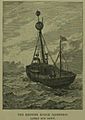
- 1840: The buoy was replaced by a lightship called LV Kentish Knock. Lightships are like floating lighthouses.
- 1860: The Dutch ship Hillechina was wrecked by accident.
- 1875: The German merchant ship SS Deutschland was wrecked here.
- 1885: The British ship Canoese from Liverpool was wrecked.
- 1892: The British merchant ship, SS Dilsberg, from Glasgow, was wrecked.
- 1894: A telephone cable was laid from the mainland to the lightship. This allowed people on the lightship to communicate.
- 1916: During World War I, the German Zeppelin L15 crashed here.
- 1917: The German U-boat SM UC-6 was likely sunk here by mine nets or a British seaplane.
- 1940: During World War II, the British G-class Destroyer HMS Grenville sank after hitting a mine.
- 1949 to 1991: Several different Trinity House lightships (№8, №14, №20, №23, №3) were stationed here over these years to guide ships.
- 2011: By this year, a lighted buoy was still in place to mark the area.
- 2014: Plans for the second phase of the London Array wind farm were cancelled to protect the rare red-throated divers that visit the Kentish Knock.
Images for kids
-
The lightvessel sunk in 1886

