Keokuk County, Iowa facts for kids
Quick facts for kids
Keokuk County
|
|
|---|---|
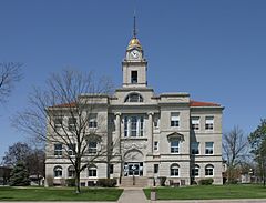
Courthouse in Sigourney is on the NRHP
|
|
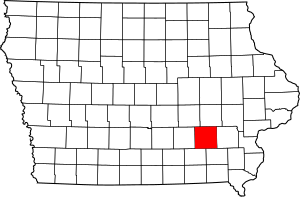
Location within the U.S. state of Iowa
|
|
 Iowa's location within the U.S. |
|
| Country | |
| State | |
| Founded | February 17, 1843 |
| Named for | Keokuk (Sauk leader) |
| Seat | Sigourney |
| Largest city | Sigourney |
| Area | |
| • Total | 580 sq mi (1,500 km2) |
| • Land | 579 sq mi (1,500 km2) |
| • Water | 0.7 sq mi (2 km2) 0.1% |
| Population
(2020)
|
|
| • Total | 10,033 |
| • Estimate
(2023)
|
9,914 |
| • Density | 17.30/sq mi (6.68/km2) |
| Time zone | UTC−6 (Central) |
| • Summer (DST) | UTC−5 (CDT) |
| Congressional district | 2nd |
Keokuk County is a county located in the state of Iowa, USA. In 2020, about 10,033 people lived here. The main town, or county seat, is Sigourney.
Contents
History of Keokuk County
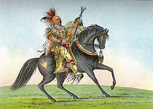
Keokuk County was officially started in 1837. It was named after Chief Keokuk. He was a respected leader of the Sauk tribe. Chief Keokuk believed in peace with the new settlers.
In May 1843, the county was opened for people to move in and settle. At first, another county, Washington County, helped manage its laws and rules. Keokuk County got its own government in 1844. But it took until 1856 to choose Sigourney as the county seat.
This county is special because it has two county fairs! The Keokuk County Fair is held in What Cheer. Right after that, the Keokuk County Expo happens in Sigourney.
The Keokuk County Courthouse was built in 1911. It is located in Sigourney's historic Public Square. This building has been on the National Register of Historic Places since 1981. This means it's an important historical site.
Geography and Nature
Keokuk County covers about 580 square miles. Most of this area, about 579 square miles, is land. Only a tiny part, 0.7 square miles, is water. The South Branch of the Skunk River flows through the lower part of the county. It helps drain the land.
Main Roads in Keokuk County
Neighboring Counties
- Poweshiek County − to the northwest
- Iowa County − to the north
- Washington County − to the east
- Jefferson County − to the southeast
- Wapello County − to the southwest
- Mahaska County − to the west
People of Keokuk County
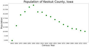
The population of Keokuk County has changed over time. In 1850, there were about 4,800 people. The population grew a lot by 1900, reaching almost 25,000. Since then, it has slowly decreased.
2020 Census Information
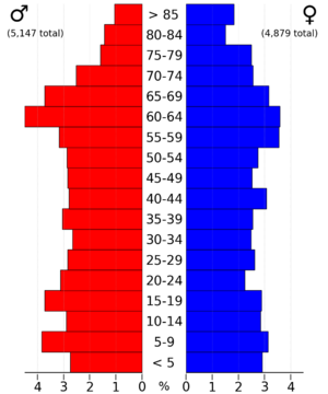
In 2020, the census counted 10,033 people living in Keokuk County. This means there were about 17 people per square mile. Most people (96.81%) said they belonged to one race. About 93% were non-Hispanic White. Other groups included Black, Hispanic, Native American, and Asian people.
There were 4,654 homes in the county. About 4,174 of these homes were lived in.
Cities and Towns
Keokuk County has several cities and smaller communities.
Cities in Keokuk County
- Delta
- Gibson
- Harper
- Hayesville
- Hedrick
- Keota
- Keswick
- Kinross
- Martinsburg
- North English (partly in another county)
- Ollie
- Richland
- Sigourney
- South English
- Thornburg
- Webster
- What Cheer
Smaller Communities (Unincorporated)
These are places that are not officially cities or towns.
Townships
Counties are often divided into smaller areas called townships. Here are the townships in Keokuk County:
- Adams
- Benton
- Clear Creek
- East Lancaster
- English River
- Jackson
- Lafayette
- Liberty
- Plank
- Prairie
- Richland
- Sigourney
- Steady Run
- Van Buren
- Warren
- Washington
- West Lancaster
Population of Cities and Towns (2020)
This table shows how many people lived in each city or town in Keokuk County in 2020. The county seat is marked with a dagger (†).
| Rank | City/Town | Type | Population (2020) |
|---|---|---|---|
| 1 | † Sigourney | City | 2,004 |
| 2 | North English | City | 1,065 |
| 3 | Keota | City | 897 |
| 4 | Hedrick | City | 728 |
| 5 | What Cheer | City | 607 |
| 6 | Richland | City | 542 |
| 7 | Keswick | City | 242 |
| 8 | South English | City | 202 |
| 9 | Ollie | City | 201 |
| 10 | Harper | City | 118 |
| 11 | Martinsburg | City | 110 |
| 12 | Webster | City | 94 |
| 13 | Kinross | City | 80 |
| 14 | Thornburg | City | 45 |
| 15 | Hayesville | City | 41 |
Education
Several school districts serve the students of Keokuk County:
- Eddyville-Blakesburg-Fremont Community School District
- English Valleys Community School District
- Keota Community School District
- Pekin Community School District
- Sigourney Community School District
- Tri-County Community School District
Some school districts that used to exist in the area include:
- Eddyville–Blakesburg Community School District
- Fremont Community School District
- Hedrick Community School District
See also
 In Spanish: Condado de Keokuk para niños
 | Selma Burke |
 | Pauline Powell Burns |
 | Frederick J. Brown |
 | Robert Blackburn |


