
Kittery Point, Maine facts for kids
Quick facts for kids
Kittery Point, Maine
|
|
|---|---|

|
|

Kittery Point, Maine
Location in Maine
|
|
| Country | United States |
| State | Maine |
| County | York |
| Area | |
| • Total | 2.57 sq mi (6.66 km2) |
| • Land | 1.91 sq mi (4.94 km2) |
| • Water | 0.66 sq mi (1.72 km2) |
| Elevation | 43 ft (13 m) |
| Population
(2020)
|
|
| • Total | 1,009 |
| • Density | 528.83/sq mi (204.18/km2) |
| Time zone | UTC-5 (Eastern (EST)) |
| • Summer (DST) | UTC-4 (EDT) |
| ZIP code |
03905
|
| Area code(s) | 207 |
| FIPS code | 23-37375 |
| GNIS feature ID | 0569232 |

Kittery Point is a small community in the town of Kittery, Maine, in the United States. It is located in York County. People first settled here in 1623. Kittery Point has a long history, starting with the first sailors who came to the coast. This area later became part of the Massachusetts Bay Colony and then the State of Maine.
Kittery Point is right next to the Atlantic Ocean. It is home to cool places like Fort McClary State Historic Site and Fort Foster Park. These parks are great for exploring history and nature. You can also find Seapoint Beach and part of the Rachel Carson National Wildlife Refuge here.
Kittery Point is part of a larger group of towns called the Portland-South Portland-Biddeford Metropolitan Statistical Area. In 2020, about 1,009 people lived in Kittery Point.
Contents
History of Kittery Point
People started living in Kittery Point as early as 1623. The southern part of Kittery was once called Champernowne's. This name came from Sir Francis Champernowne, who was an important merchant and explorer. He was also a cousin of Sir Ferdinando Gorges, who helped start settlements north of the Massachusetts Bay Colony.
Nicholas Shapleigh built the first house in the area. Edward Godfrey set up a trading post in 1632. Early jobs included fishermen, hunters, and trappers. Others cut down trees, which was called timber harvesting. This timber was sent to England or the West Indies. The town of Kittery officially became a town in 1652. This happened when Maine joined the Massachusetts Bay Colony.
The Pepperrell Family
The Pepperrells were a very important family in Kittery Point. They started fishing businesses to sell fish to London. William Pepperrell Sr. came from England as a fisherman's helper. He built a huge business empire. His son, Sir William Pepperrell, took over and made it even bigger.
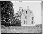
Sir William became the first "baronet" in New England. A baronet is a special title given by the king or queen. He earned this title for leading a militia (a group of citizen soldiers) that defeated the French in 1745. This victory happened at the Siege of Louisbourg. His large house, built in 1733, is still a landmark at Pepperrell Cove. In 1760, his wife built the Lady Pepperrell House. This beautiful Georgian style building is now a private home.
Sir William Pepperrell also built a fancy wooden house called the Sparhawk Mansion. He gave it to his daughter when she married Nathaniel Sparhawk in 1750. The house had 19 rooms with beautiful wood carvings. Sadly, this mansion was torn down in 1967.
Oldest House and Forts
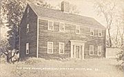
The John Bray House is more fortunate. It was built by a shipwright (someone who builds ships) in 1662. Many people believe it is the oldest house still standing in Maine. It was almost torn down for new buildings because of its great view. But instead, it has been restored.
Fort McClary is a historic defense fort built on land that once belonged to Sir William Pepperrell. It was built to protect Portsmouth Harbor. Today, it is Fort McClary State Historic Site. You can see a blockhouse there from 1844. It was added to the National Register of Historic Places in 1969.
Another fort, Fort Foster, was built later by the government on Gerrish Island. It covers about 92 acres. Now, the town of Kittery owns it. Fort Foster Park offers amazing views of Portsmouth Harbor, Whaleback Lighthouse, and the Isles of Shoals.
Geography
Kittery Point covers about 6.7 square kilometers (2.57 square miles). About 4.9 square kilometers (1.91 square miles) is land, and 1.7 square kilometers (0.66 square miles) is water. Kittery Point is surrounded by Spruce Creek, the Piscataqua River, the Atlantic Ocean, and Brave Boat Harbor.
Population Information
| Historical population | |||
|---|---|---|---|
| Census | Pop. | %± | |
| 2020 | 1,009 | — | |
| U.S. Decennial Census | |||
In 2020, the population of Kittery Point was 1,009 people.
Fun Things to See and Do
Here are some interesting places to visit in Kittery Point:
- Fort Foster Park
- Fort McClary State Historic Site
- Kittery Art Association
- Kittery Historical and Naval Museum
- Rachel Carson National Wildlife Refuge
- Spruce Creek
Famous People from Kittery Point
Some notable people who have lived in Kittery Point include:
- John Haley Bellamy, a woodcarver and folk artist
- Sir William Pepperrell, a famous merchant and soldier
- Celia Thaxter, a well-known poet and writer
- John Treworgie, a trading post agent and politician
- Helen Magill White, the first American woman to earn a Ph.D.
Pictures of Kittery Point
-
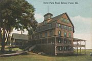
Hotel Parkfield around 1912
-
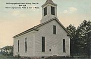
First Congregational Church, built in 1730, around 1912
-
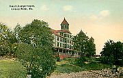
Hotel Champernowne in 1911
-
Sparhawk House, around 1900, which was later torn down
-
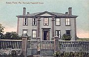
The Lady Pepperrell House around 1910, now a private home
-
John Bray House around 1920


Kittery Point in Pop Culture
DinoSquad is an American animated television show. It was produced by DIC Entertainment and aired from 2007 to 2009. The story of DinoSquad takes place in Kittery Point, Maine!
See also
 In Spanish: Kittery Point (Maine) para niños
