Kunturiri (Bolivia and Chile) facts for kids
Quick facts for kids Kunturiri |
|
|---|---|

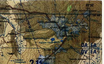
Map of the Kunturiri complex
|
|
| Highest point | |
| Elevation | 5,762 m (18,904 ft) |
| Geography | |
| Location | Bolivia / Chile |
| Parent range | Andes |
| Geology | |
| Age of rock | 650,000 ± 70,000 years |
Kunturiri is a large volcano located in the Andes mountains. It sits right on the border between Bolivia and Chile. The name Kunturiri comes from the Aymara language, where kunturi means "condor."
This impressive mountain reaches a height of about 5,762 meters (18,904 feet). On the Chilean side, you can find it in the Arica y Parinacota Region. In Bolivia, it's located in parts of the Oruro Department and the La Paz Department.
Contents
About Kunturiri Mountain
Kunturiri is surrounded by other mountains. To its northeast in Bolivia is Jach'a Kunturiri. To the east is Nevado Pumuta, and to the south is Patilla Pata. Northwest of Kunturiri lies Laram Q'awa.
Ice and Water on Kunturiri
Kunturiri, along with some nearby mountains, is covered in ice. This ice is important because it melts and forms many rivers that flow down the mountain's sides.
You can also find several lakes on Kunturiri. People often call them the Casiri Lakes. Some of these lakes include Sora Pata, Ch'iyar Quta, Casiri Macho, and Casiri Hembra.
How Kunturiri Was Formed
Kunturiri is actually part of a group of volcanoes along the border between Bolivia and Chile. These volcanoes grew on top of older layers of rock formed by ancient eruptions.
Volcanic Activity
The Kunturiri area is made up of three separate stratovolcanoes. These volcanoes were created by two types of eruptions:
- Effusive eruptions: Where lava flows out slowly.
- Explosive eruptions: Where ash, rocks, and gas are thrown out with great force.
The rocks that make up Kunturiri range from rhyodacite to rhyolite. These rocks contain small crystals of minerals like biotite, plagioclase, and pyroxene.
Past Eruptions and Age
About 3 to 2.2 million years ago, the Kunturiri volcanic area was the source of a huge eruption. This eruption created the Lauca-Perez Ignimbrite. An ignimbrite is a type of rock formed from hot ash and rock fragments. This massive eruption covered a huge area, about 15,000 to 20,000 square kilometers (5,800 to 7,700 square miles). It even reached as far as the Pacific Ocean! This event left a unique landscape on the Altiplano, a high plateau in the Andes.
The eruption likely left behind a large caldera, which is a basin-shaped depression formed when a volcano collapses. This caldera is probably now buried under the Kunturiri volcanic complex.
Scientists used to think the Kunturiri volcanoes were much older, about 7 to 9 million years old. However, newer studies using a method called argon-argon dating show that the rocks from Kunturiri are about 650,000 years old.
Nearby Volcanic Features
While Kunturiri itself does not have fumarolic activity (steam and gas vents), a nearby area called Kakepe does have hydrothermal activity. This means there are hot springs or vents where hot water flows.
Other important volcanoes in this region are Pomerape and Parinacota. These volcanoes, along with Kunturiri, are built along something called the Condoriri lineament. This lineament might be like a pathway for magma (molten rock) to reach these three volcanoes from deep inside the Earth.
See also
 In Spanish: Kunturiri para niños
 | Emma Amos |
 | Edward Mitchell Bannister |
 | Larry D. Alexander |
 | Ernie Barnes |


