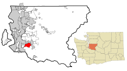
Lake Morton-Berrydale, Washington facts for kids
Quick facts for kids
Lake Morton-Berrydale, Washington
|
|
|---|---|

Location of Lake Morton-Berrydale, Washington
|
|
| Country | United States |
| State | Washington |
| County | King |
| Area | |
| • Total | 12.5 sq mi (32.3 km2) |
| • Land | 12.3 sq mi (31.8 km2) |
| • Water | 0.2 sq mi (0.5 km2) |
| Elevation | 470 ft (140 m) |
| Population
(2020)
|
|
| • Total | 10,474 |
| • Density | 828/sq mi (319.6/km2) |
| Time zone | UTC-8 (Pacific (PST)) |
| • Summer (DST) | UTC-7 (PDT) |
| FIPS code | 53-37567 |
| GNIS feature ID | 2408545 |
Lake Morton-Berrydale is a special kind of community in King County, Washington, United States. It's called a "census-designated place" (CDP). This means it's like a town or neighborhood that the government counts for population, but it doesn't have its own city government.
In 2020, about 10,474 people lived in Lake Morton-Berrydale. It is known as one of the wealthier areas in Washington state.
Where is Lake Morton-Berrydale?
Lake Morton-Berrydale is located in the southwestern part of King County. You can find it at these coordinates: 47°19′54″N 122°6′12″W / 47.33167°N 122.10333°W.
It shares borders with several other cities and communities:
- To the west: Auburn
- To the northwest: Kent
- To the north: Covington
- To the northeast: Maple Valley
- To the east: Black Diamond
- To the south: The Lake Holm community
The southern edge of Lake Morton-Berrydale follows Covington Creek and Big Soos Creek. These creeks flow west into the Green River. The community gets its name from Lake Morton, which is in the eastern part of the area. The neighborhood of Berrydale is in the northwest.
Travel and Size
Washington State Route 18 runs along the northwest border of Lake Morton-Berrydale. This highway can take you about 17 miles (27 km) northeast to Interstate 90 near Snoqualmie. It also goes about 6 miles (10 km) southwest to Auburn.
From Lake Morton-Berrydale, you can reach downtown Tacoma about 20 miles (32 km) to the southwest. Downtown Seattle is about 22 miles (35 km) to the northwest.
The total area of Lake Morton-Berrydale is about 32.3 square kilometers (12.5 square miles). Most of this area, about 31.8 square kilometers (12.3 square miles), is land. The rest, about 0.5 square kilometers (0.2 square miles), is water, making up about 1.6% of the total area.
Population and People
The number of people living in Lake Morton-Berrydale has grown over the years:
| Historical population | |||
|---|---|---|---|
| Census | Pop. | %± | |
| 2000 | 9,659 | — | |
| 2010 | 10,160 | 5.2% | |
| 2020 | 10,474 | 3.1% | |
| U.S. Decennial Census 2020 Census |
|||
According to the census from 2000, there were 9,659 people living here. There were 3,245 households, which are groups of people living together in one home. Most of these households (2,735) were families.
The population density was about 773.6 people per square mile (298.6 people per square kilometer). There were also 3,312 housing units, like houses or apartments.
Most people in Lake Morton-Berrydale in 2000 were White (92.50%). There were also smaller groups of African American, Native American, Asian, and Pacific Islander residents. About 2.31% of the population was Hispanic or Latino.
Many households (43.3%) had children under 18 living with them. Most households (74.5%) were married couples living together. The average household had about 2.98 people, and the average family had about 3.21 people.
The population was spread out by age:
- 29.1% were under 18 years old.
- 6.4% were between 18 and 24.
- 29.1% were between 25 and 44.
- 28.7% were between 45 and 64.
- 6.6% were 65 years old or older.
The average age of people in Lake Morton-Berrydale was 38 years. For every 100 females, there were about 105.5 males.
In 2000, the average income for a household was $75,337, and for a family, it was $80,516. Only a small number of families (0.5%) and people (1.7%) lived below the poverty line.
See also
 In Spanish: Lake Morton-Berrydale (Washington) para niños
 | Shirley Ann Jackson |
 | Garett Morgan |
 | J. Ernest Wilkins Jr. |
 | Elijah McCoy |

