
Lake Rotomā facts for kids
Quick facts for kids Lake Rotomā |
|
|---|---|
| Lake Rotoma | |

Lake Rotomā
|
|

Lake Rotomā
Location in North Island

Lake Rotomā
Location in New Zealand
|
|
| Location | Rotorua Lakes, Bay of Plenty Region, North Island |
| Coordinates | 38°02′51″S 176°35′16″E / 38.0476°S 176.5878°E |
| Lake type | Crater lake |
| Basin countries | New Zealand |
| Max. length | 5.2 km (3.2 mi) |
| Max. width | 4.7 km (2.9 mi) |
| Surface area | 11.2 km2 (4.3 sq mi) |
| Average depth | 38.6 m (127 ft) |
| Max. depth | 83 m (272 ft) |
| Surface elevation | 316 m (1,037 ft) |
| Islands | 1 sunken island |
Lake Rotomā (also called Rotoma) is a beautiful lake in New Zealand's North Island. It's part of the 11 lakes in the Rotorua Lakes area, which was once known as the Hot Lakes district. You can find Lake Rotomā in the Bay of Plenty Region.
This lake is the fourth largest in the Rotorua Lakes group. It sits to the east of Lake Rotorua, forming a chain with two other lakes: Lake Rotoiti and Lake Rotoehu. Lake Rotomā is located about halfway between the city of Rotorua and the town of Whakatāne.
The water in Lake Rotomā is very clean. You can often see clearly up to 13 metres deep! The lake is deepest in its northern part, reaching 83 metres, and 73.5 metres in the southern part.
Contents
How Lake Rotomā Was Formed
Lake Rotomā was created inside a large bowl-shaped area called the Rotomā Caldera. About 9,500 years ago, a huge volcanic explosion happened. Lava flows from this explosion blocked the lake's natural exit. This caused the water to collect and form the lake we see today.
The hills around the south and east sides of the lake are made of a type of rock called rhyolite. This rock came from eruptions in the same area, including the Haroharo Caldera and Mount Tarawera. Because of these rocks, Lake Rotomā doesn't have any rivers flowing out of it on the surface. However, there are springs, which suggest that some lake water flows out underground.
The water level of Lake Rotomā changes over time. It can get very high or very low every 10 to 15 years. When the water level is extremely low, a special "sunken island" in the lake, called Motutara, can sometimes be seen above the water.
History of the Area
Building the Road

Before a proper road was built around Lake Rotomā, Māori used trails to travel between Rotorua and the Eastern Bay of Plenty. These trails were only good for walking, not for horses. Travellers from Rotorua could only go as far as Tikitere on the rough path.
Work on the road from Tikitere to Rotomā started in May 1895. Road workers faced a tough challenge building the road over the Rotomā hill. A good road was also built from Te Ngae in Rotorua to Tikitere.
Once the road was finished, horse-drawn carriages began to use it. Public coach services started in 1907. The R.M. Company offered a service twice a week from Rotorua to Ōpōtiki, carrying mail and passengers. In 1910, they used a bigger coach pulled by five horses, which could carry 10 passengers.
In 1916, the first regular car service began. Cars like the Cadillac took about 5 hours to travel from Rotorua to Whakatāne. However, depending on the road conditions, it could take up to 9 hours, just like the horse coaches. By the late 1920s, the road improved, and the journey took only 3 hours. Today, this trip takes just one hour and 20 minutes!
In 1947, many workers were busy building the Rotorua to Whakatāne highway. The old road was only about 12 feet wide, which caused problems as more cars used it. In 1956, the lake level rose very high, forcing the road to be moved to higher ground. Even worse flooding happened in 1962. A famous landmark called the "cheese cutting," a large wedge-shaped rock, was destroyed and used to build up the road.
Businesses and Places

Over the years, many businesses have opened and closed at Rotomā. Most of these places were set up to offer travellers a place to rest, eat, and stay the night.
Some past businesses included:
- "Rotoma Tearooms and Post Office" (later called "The Kettle Store and Tearooms," then "The Kettle Store and Garage")
- "T & K Service Station"
- "Stillwater Lodge & Motel"
- "Rotoma Accommodation House"
- "El Toreador Dine and Dance"
- "Atkinson's Fishing Lodge" (later called "Merge Lodge")
- "Rotoma Traders"
In 1912, a trip between Rotorua and Whakatāne could take up to 9 hours. So, places where horses could be changed were set up every 14 miles from Rotorua. The changing station at the west end of Rotomā became a popular rest stop. John Baker ran a post office and tearooms there. He was famous for his corned beef meals, offering it with potatoes and cabbage or as sandwiches.
The Pilbrow family bought the Rotoma Tearooms and Post Office in 1948. They made the business bigger by adding a general store and renamed it The Kettle Store and Tearooms. Later, they built a garage for car repairs, and the business became The Kettle Store and Garage. They also added petrol pumps, creating the T & K Filling Station. In 1961, heavy rain caused serious flooding. The floodwaters lifted the petrol tanks out of the ground! The road had to be built up to stop the water. Pumps worked day and night for weeks to keep the business from flooding completely. The Pilbrow family also created Oxford Road.
Atkinson's Fishing Lodge was originally a home built in the early 1900s by Mr. and Mrs. C. Atkinson. They farmed near the lake and had an orchard. Their home was turned into a lodge that was very popular with fishermen. In 1960, Geoff and Roy Warwick took over the lodge and renamed it Merge Lodge. It had six bedrooms, a billiard room, two kitchens, and two lounges. Today, there is a caravan park where Merge Lodge used to be.
Learning at Lake Rotomā
The Sunken Island
In the southern part of Lake Rotomā, four buoys mark the spot of Motutara, a sunken island. This island sits just below the lake's surface. Sometimes, when the lake level drops very low, you can see the top of the island.
Long ago, there was a Māori village on this island. According to legend, a powerful and dangerous old Tohunga (a wise person or priest) named Te Rarau-mai-Waho lived there. One night, he returned from a visit and called out to the villagers from the lake's edge, asking for a canoe. No one answered him. In his anger, the Tohunga put a curse on the island and its people. The villagers heard his terrible screams but didn't realize what would happen. The curse caused the island to slowly sink. By morning, it was completely underwater. Only bodies and pieces of wreckage were floating on the lake. Some people escaped by swimming to the shore and later settled in the South Island.
The Waikato Underwater Club has explored Motutara. They found two flat areas, like platforms, and some hāngī (earth oven) stones at the highest point.
Who Lives Here?
Statistics New Zealand describes Rotomā as a rural settlement. It covers about 0.83 square kilometres. As of 2018, it had an estimated population of 255 people.
Before the 2023 census, the settlement was a bit smaller. In the 2018 New Zealand census, Rotomā had 255 people. This was a big increase from 2013 and 2006. There were 99 homes, with slightly more males than females. The average age was 50.2 years. About 15.3% of the people were under 15 years old.
Most people in Rotomā were European/Pākehā (80.0%), and 30.6% were Māori. Some people identified with more than one ethnic group.
When asked about religion, 57.6% said they had no religion. About 28.2% were Christian, and 3.5% had Māori religious beliefs.
Of those aged 15 or older, 12.5% had a university degree or higher. The average income was $23,400. About 37.5% of people aged 15 or older worked full-time.
Early Settlers
When the first roads were being built, people noticed there weren't many Māori settlements in Rotomā or nearby Lake Rotoehu. However, old fortified villages called pā sites, food storage pits, farming areas, and burial sites have been found around Lake Rotomā and its hills. The Ngāti Tūwharetoa tribe might not have lived there all the time. They probably camped there temporarily to hunt and fish. Later, Ngāti Tūāhuriri, a sub-tribe of Ngāti Pikiao, lived at Rotomā. Māori living at nearby Rotoiti said that frequent fighting between Māori and Pākehā (Europeans) caused this Māori population to leave. By the time road construction started in 1895, they had left Lake Rotomā.
A count of people from 1874 to 1891 showed no one living in Rotomā. In 1896, a count showed 33 people. These were likely the road workers and their families who had set up a camp at the east end of Oneroa beach.
Oxford Road
In 1948, Mr. and Mrs. T.H. Pilbrow and their children moved to Lake Rotomā from Oxford in Canterbury. They bought the Rotoma Tearooms and Post Office, which came with 25 acres of land.
Most land in the area was leased, meaning you paid to use it but didn't own it. The Pilbrows realized how valuable their 25 acres of owned land was. In 1950, they decided to divide it into smaller pieces. They surveyed 63 sections, most of them a quarter-acre in size. Four of these sections were set aside by the Rotorua County Council for a reserve. Seventeen sections were along the main road, but a new road was needed to reach the sections at the back. The Pilbrows named this new road "Oxford Road" to remember their hometown.
Education in Rotomā
Lake Rotomā School is a school for students from Year 1 to 8. It's a state school, meaning it's funded by the government. As of 2024, it has 28 students.
The first school opened on February 2, 1928, in an old tearooms building. Mr. E.G. Sutherland taught 8 students there. He once said it was "probably the worst building in New Zealand." He also mentioned that when the weather was too bad, they just had a holiday!
A new school was built and opened on May 25, 1936, at its current spot on Soda Springs Road. It had 29 students. The number of students changed often because many people lived in Rotomā only for a short time. Local timber mills, Tunnicliffe's Mill and Rendall's Mill, helped create a more stable population. This led to the school becoming very crowded. In 1973, the school had 55 students, and conditions for staff and children were difficult. On August 14, 1973, most parents kept their children home to protest the lack of improvements. This protest got a lot of media attention. In October, the Minister of Education ordered a new school to be built. It opened on November 16, 1974.
From 1948, Mr. Tam Pilbrow ran the first bus service to the school using a Hillman car. In 1952, George Graham and Mr. Pilbrow's son Ken took over the service, using a Bradford van from the Kettle Store. Mr. Gavin Wyllie bought the Kettle Store and Garage in 1958. He started taking children to school in his V.W. combi van. However, when Rendall's Mill closed at the end of that year, there weren't enough children for him to continue the service.
Protecting Lake Rotomā
Sadly, some non-native plants have been introduced to Lake Rotomā. These plants have grown very fast and have taken over, pushing out the native plants. Because of this, the number of crayfish in the lake has gone down a lot.
The local Te Arawa tribe is working to remove these unwanted plants and help the crayfish population grow again. They are using special woven flax mats called uwhi. These mats are placed on the bottom of the lake. They stop the invasive plants from growing, while allowing the thinner native plants to thrive. Other materials like burlap and rubber mats didn't work because gas from decaying plants would build up and lift them off the lake bottom.
Images for kids
-
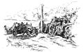
Tourists on the Rotomā hill. Drawn from a "Weekly News" photograph dated 9 May 1918
-
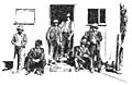
Drawing of travellers outside J.Baker's Tearooms and Post Office at Lake Rotomā, c1900
