
Lamb County, Texas facts for kids
Quick facts for kids
Lamb County
|
|
|---|---|

Lamb County Courthouse in Littlefield
|
|

Location within the U.S. state of Texas
|
|
 Texas's location within the U.S. |
|
| Country | |
| State | |
| Founded | 1908 |
| Named for | George A. Lamb |
| Seat | Littlefield |
| Largest city | Littlefield |
| Area | |
| • Total | 1,018 sq mi (2,640 km2) |
| • Land | 1,016 sq mi (2,630 km2) |
| • Water | 1.5 sq mi (4 km2) 0.2% |
| Population
(2020)
|
|
| • Total | 13,045 |
| • Density | 12.814/sq mi (4.9476/km2) |
| Time zone | UTC−6 (Central) |
| • Summer (DST) | UTC−5 (CDT) |
| Congressional district | 19th |
Lamb County is a county located in the U.S. state of Texas. In 2020, about 13,045 people lived there. The main town and county seat is Littlefield. The county was created in 1876 but officially started working in 1908. It is named after George A. Lamb, a soldier who died in the Battle of San Jacinto.
Lamb County was home to Bill W. Clayton, who was the Speaker of the Texas House from 1975 to 1983. It is also the birthplace of famous country music singer Waylon Jennings.
Contents
History of Lamb County
Lamb County was formed in 1876 from parts of Bexar County. It was named after George A. Lamb, a soldier who fought bravely in the Battle of San Jacinto.
In the 1960s, the amount of underground water, called the water table, started to decrease. From the 1980s until 2023, the number of people living in the county went down by about one-third. Between 2013 and 2023, the population dropped by about 8%.
During the COVID-19 pandemic, Lamb County faced serious challenges. Sadly, as of March 2023, about 1 in 100 residents had passed away from COVID-19. This made Lamb County one of the counties with the highest death rates from the virus in the United States.
By 2023, farms in the area were struggling with water scarcity, meaning there wasn't enough water. Because of this, many younger people moved to other counties to find jobs.
Geography of Lamb County
Lamb County covers a total area of about 1,018 square miles. Most of this area is land, with only about 1.5 square miles (0.2%) covered by water.
Counties Nearby
Lamb County shares its borders with several other counties:
- Castro County (to the north)
- Hale County (to the east)
- Hockley County (to the south)
- Bailey County (to the west)
- Parmer County (to the northwest)
- Lubbock County (to the southeast)
- Cochran County (to the southwest)
Population in Lamb County
The population of Lamb County has changed over the years. Here's how it has grown and shrunk:
| Historical population | |||
|---|---|---|---|
| Census | Pop. | %± | |
| 1890 | 4 | — | |
| 1900 | 31 | 675.0% | |
| 1910 | 540 | 1,641.9% | |
| 1920 | 1,175 | 117.6% | |
| 1930 | 17,452 | 1,385.3% | |
| 1940 | 17,606 | 0.9% | |
| 1950 | 20,015 | 13.7% | |
| 1960 | 21,896 | 9.4% | |
| 1970 | 17,770 | −18.8% | |
| 1980 | 18,669 | 5.1% | |
| 1990 | 15,072 | −19.3% | |
| 2000 | 14,709 | −2.4% | |
| 2010 | 13,977 | −5.0% | |
| 2020 | 13,045 | −6.7% | |
| U.S. Decennial Census 1850–2010 2010 2020 |
|||
In 2000, there were 14,709 people living in Lamb County. About 5,360 households and 3,991 families called the county home. The population density was about 14 people per square mile.
The people in Lamb County come from many different backgrounds. In 2000, about 76.1% of the population was White, 4.3% Black or African American, and 0.7% Native American. About 43.5% of the population was of Hispanic or Latino background.
In 2000, about 35.4% of households had children under 18 living with them. The average household had 2.69 people, and the average family had 3.19 people.
The median age in the county was 36 years old. This means half the people were younger than 36 and half were older. For every 100 females, there were about 94.2 males.
The median income for a household in the county was $36,898. This means half the households earned more than this amount and half earned less. About 18.0% of families and 10.9% of the total population lived below the poverty line.
Transportation in Lamb County
Main Highways
 U.S. Highway 70
 U.S. Highway 84
 U.S. Highway 385
Airports
The Littlefield Municipal Airport is located in Lamb County. It is about 3 miles (5 km) west of the center of Littlefield, Texas.
Communities in Lamb County
Cities
- Amherst
- Earth
- Littlefield (This is the county seat, the main town for county government)
- Olton
- Sudan
Town
Census-Designated Place
Unincorporated Community
Education in Lamb County
Several school districts serve the students in Lamb County:
- Amherst Independent School District
- Anton Independent School District
- Littlefield Independent School District
- Muleshoe Independent School District
- Olton Independent School District
- Springlake-Earth Independent School District
- Sudan Independent School District
- Whiteface Consolidated Independent School District
The county is also served by South Plains College, which offers higher education.
Media in Lamb County
As of 2023, Lamb County has one newspaper called Lamb County Leader-News. It has three employees. Sadly, one employee passed away from COVID-19 in 2022, and the newspaper did not hire another person.
Another newspaper, Olton Enterprise, stopped publishing in 2021.
In 2023, a writer named Alejandro de la Garza noted that during the COVID-19 pandemic, many local news sources were affected. He said that for many residents, their Facebook feeds started to take the place of local news.
Healthcare in Lamb County
In August 2022, about 43% of the county's residents had received at least one COVID-19 vaccination.
Images for kids
-
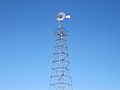
Littlefield claims the world's tallest windmill.
-
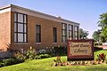
Lamb County Library in downtown Littlefield across from the First Baptist Church
-
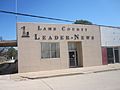
Lamb County Leader-News in Littlefield
-
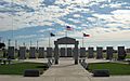
Lamb County Veterans Memorial
-
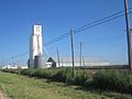
Littlefield Farmers Co-op grain elevator


See also
 In Spanish: Condado de Lamb para niños
