Hockley County, Texas facts for kids
Quick facts for kids
Hockley County
|
|
|---|---|

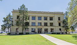
The Hockley County Courthouse in Levelland
|
|

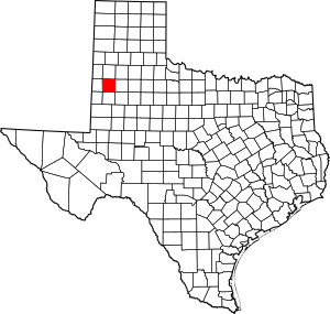
Location within the U.S. state of Texas
|
|
 Texas's location within the U.S. |
|
| Country | |
| State | |
| Founded | 1921 |
| Named for | George Washington Hockley |
| Seat | Levelland |
| Largest city | Levelland |
| Area | |
| • Total | 909 sq mi (2,350 km2) |
| • Land | 908 sq mi (2,350 km2) |
| • Water | 0.2 sq mi (0.5 km2) 0.02% |
| Population
(2020)
|
|
| • Total | 21,537 |
| • Density | 23.693/sq mi (9.148/km2) |
| Time zone | UTC−6 (Central) |
| • Summer (DST) | UTC−5 (CDT) |
| Congressional district | 19th |
Hockley County is a special area, like a district, located in the state of Texas, USA. It's where people live and work together, and it has its own local government. In 2020, about 21,537 people called Hockley County home. The main town and the center of the county's government is Levelland.
Hockley County was first marked out in 1876. However, it wasn't fully set up with its own government until 1921. The county is named after George Washington Hockley. He was an important person in the early history of Texas.
Contents
History of Hockley County
Hockley County was officially created in 1876. Its land was taken from parts of two older counties, Bexar and Young Counties.
Who Was George Washington Hockley?
The county is named after George Washington Hockley. He was a brave leader during the Texas Revolution. He commanded the artillery (big guns) in the important Battle of San Jacinto. Later, he became the Secretary of War for the Republic of Texas. This was before Texas joined the United States.
Geography of Hockley County
Hockley County is quite large! It covers a total area of about 909 square miles. Almost all of this area, about 908 square miles, is land. Only a tiny bit, about 0.2 square miles, is covered by water.
Main Roads in Hockley County
Several important highways run through Hockley County. These roads help people travel and transport goods across the county and to other parts of Texas.
Neighboring Counties
Hockley County shares its borders with several other counties.
- To the north: Lamb County
- To the east: Lubbock County
- To the south: Terry County
- To the west: Cochran County
- To the southwest: Yoakum County
- To the northwest: Bailey County
- To the northeast: Hale County
- To the southeast: Lynn County
Population of Hockley County
| Historical population | |||
|---|---|---|---|
| Census | Pop. | %± | |
| 1900 | 44 | — | |
| 1910 | 137 | 211.4% | |
| 1920 | 137 | 0.0% | |
| 1930 | 9,298 | 6,686.9% | |
| 1940 | 12,693 | 36.5% | |
| 1950 | 20,407 | 60.8% | |
| 1960 | 22,340 | 9.5% | |
| 1970 | 20,396 | −8.7% | |
| 1980 | 23,230 | 13.9% | |
| 1990 | 24,199 | 4.2% | |
| 2000 | 22,716 | −6.1% | |
| 2010 | 22,935 | 1.0% | |
| 2020 | 21,537 | −6.1% | |
| U.S. Decennial Census 1850–2010 2010 2020 |
|||
In 2020, the population of Hockley County was 21,537 people. The county is home to a diverse group of people from many different backgrounds.
Communities in Hockley County
Hockley County has several towns and cities where people live.
Cities
- Anton
- Levelland (This is the county seat, where the main government offices are.)
- Ropesville
Towns
Unincorporated Communities
These are smaller places that are not officially cities or towns.
Education in Hockley County
Students in Hockley County attend schools in various independent school districts.
- Anton Independent School District
- Frenship Independent School District
- Levelland Independent School District
- Ropes Independent School District
- Smyer Independent School District
- Sundown Independent School District
- Whiteface Consolidated Independent School District
- Whitharral Independent School District
For students who want to continue their education after high school, South Plains College serves the county.
See also
 In Spanish: Condado de Hockley para niños
 | Jewel Prestage |
 | Ella Baker |
 | Fannie Lou Hamer |

