
Las Llajas Canyon facts for kids
Quick facts for kids Las Llajas Canyon |
|
|---|---|

Sign at the main entrance.
|
|
| Type | Public open space, residential subdivision |
| Location | Simi Valley, CA |
| Area | 1,740 acres (700 ha) (i.e. open to public) |
| Operated by | Rancho Simi Recreation and Park District |
| Status | Open |
Las Llajas (pronounced YAH-hahs) Canyon is a beautiful natural area located in northeastern Simi Valley, California. It's part of the Marr Ranch Parkland and includes a residential area called Marrland. This open space is managed by the Rancho Simi Recreation and Park District (RSRPD).
Las Llajas Canyon, along with nearby Chivo Canyon, sits at the base of the Santa Susana Mountains. It offers amazing views of the mountains and the city. You can find large oak trees, streams, cool rock formations, and rolling hills here.
Many people visit the canyon for fun outdoor activities. You can go hiking, biking, horseback riding, or even rock climbing. It's also a great spot for watching wildlife, taking photos, running, or having a picnic. The trails are generally smooth, with many sandy parts and a green creek-bed. There's also a large basin, once planned to be a lake, now called the Las Llajas Canyon Debris Basin.
The name "Las Llajas" was first used in 1931. It's probably a mistake in spelling the Spanish words las llagas, which mean "the wounds." This name might have referred to the stigmata of a Roman Catholic saint.
In the past, a religious group called Pisgah Grande created a private community in the Llajas Canyon. At one time, this community had about thirty buildings and 150 people living there.
Contents
Wildlife in Las Llajas Canyon
Llajas Canyon is home to many different animals. You might spot a Mountain lion, California badger, Red-tailed hawk, Ring-tailed cat, Virginia opossum, Gray fox, Coyote, Bobcat, or Mule deer. Snakes like the Southern Pacific rattlesnake and birds like the Barn owl also live here. In the early 1900s, people even hunted mountain lions in this area.
The canyon is also rich in plants. You'll see native shrubs, grasses, and many oak trees. Other plants include California sycamore, brush, vines, and colorful wildflowers. You can also find wild celery, watercress, cactus, and palm trees.
Exploring Las Llajas Canyon
To reach the main entrance of Las Llajas Canyon, take the 118 highway to Simi Valley. Exit at Yosemite Avenue and head north. Turn right onto Evening Sky Drive. Continue on Evening Sky Drive for about a quarter mile until you reach the main entrance at 5715 Evening Sky Road.
There are also other ways to get into the canyon. For example, another entrance is about half a mile down the street at 3446 Yosemite Avenue. The trails in Las Llajas Canyon connect to other popular spots like Chumash Park, Rocky Peak, and Chivo Canyon. You can even reach it by hiking trails from Chatsworth, Los Angeles.
Geology of the Canyon
The rocks and land in Las Llajas Canyon date back to the Eocene Epoch, which was millions of years ago. Many fossils have been found in this area, giving us clues about ancient life.
Llajas Canyon is an arroyo, which is a dry creek bed that can fill with water during heavy rains. It's carved into silty and sandy marine sediment that is rich in salt. Because of its geology, the area can sometimes be prone to landslides and flooding.
The name "Llajas" was first used informally to describe layers of fine, conglomerate sand and sandy siltstone. These layers are found beneath the Sespe Formation and can be seen near the mouth of Las Llajas Canyon.
Images for kids
-
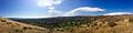
Panoramic view of Simi Valley from Las Llajas Canyon in the northeastern end of town.
